Login
Register


3CU
Cable Union Airport
Official FAA Data Effective 2026-02-19 0901Z
Chart Supplement

VFR Chart of 3CU
Sectional Charts at SkyVector.com
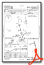
IFR Chart of 3CU
Enroute Charts at SkyVector.com
Location Information for 3CU
Coordinates: N46°11.70' / W91°14.91'Located 02 miles SE of Cable, Wisconsin on 218 acres of land. View all Airports in Wisconsin.
Surveyed Elevation is 1360 feet MSL.
Operations Data
|
|
Airport Communications
| CTAF: | 122.800 |
|---|---|
| UNICOM: | 122.800 |
| ASOS at HYR (12.8 SW): | 118.4 715-634-6138 |
| AWOS-3 at OLG (24.7 W): | 119.6 715-378-2031 |
| ASOS at ASX (25.2 NE): | 126.775 715-682-5541 |
- APCH/DEP SVC PRVDD BY MINNEAPOLIS ARTCC ON FREQS 126.45/276.4 (HAYWARD RCAG).
Nearby Navigation Aids
|
| ||||||||||||||||||||||||||||||||||||||||||||||||||||||||||||


Runway 17/35
| Dimensions: | 3709 x 75 feet / 1131 x 23 meters | |
|---|---|---|
| Surface: | Asphalt in Fair Condition | |
| Weight Limits: | S-28 | |
| Edge Lighting: | Medium Intensity | |
| Runway 17 | Runway 35 | |
| Coordinates: | N46°11.95' / W91°14.90' | N46°11.36' / W91°14.67' |
| Elevation: | 1347.1 | 1360.2 |
| Traffic Pattern: | Left | Left |
| Runway Heading: | 165° True | 345° True |
| Displaced Threshold: | 191 Feet | 563 Feet |
| Declared Distances: | TORA:3709 TODA:3709 ASDA:3709 LDA:3519 | TORA:3709 TODA:3709 ASDA:3709 LDA:3146 |
| Markings: | Non-Precision Instrument in good condition. | Non-Precision Instrument in good condition. |
| Obstacles: | 40 ft Trees 240 ft from runway, 220 ft right of center APCH RATIO 12:1 TO DSPLCD THR; 40 FT TREES 431 FT FM DSPCLD THR, 220 FT R. |
60 ft Trees 670 ft from runway, 270 ft left of center APCH RATIO 20:1 TO DSPLCD THR. |
Runway 08/26
| Dimensions: | 2194 x 150 feet / 669 x 46 meters | |
|---|---|---|
| Surface: | Turf in Good Condition | |
| Runway 08 | Runway 26 | |
| Coordinates: | N46°11.73' / W91°15.37' | N46°11.80' / W91°14.86' |
| Elevation: | 1344.0 | 1344.0 |
| Traffic Pattern: | Left | Left |
| Runway Heading: | 78° True | 258° True |
| Displaced Threshold: | 378 Feet | |
| Markings: | None in fair condition. | None in fair condition. |
| Obstacles: | 47 ft Trees 610 ft from runway, 50 ft right of center APCH RATIO 20:1 TO DSPLCD THR. |
|
Services Available
| Fuel: | 100LL (blue) |
|---|---|
| Transient Storage: | Tiedowns |
| Airframe Repair: | NONE |
| Engine Repair: | NONE |
| Bottled Oxygen: | NONE |
| Bulk Oxygen: | NONE |
Ownership Information
| Ownership: | Publicly owned | |
|---|---|---|
| Owner: | TOWN OF CABLE | AND TOWN OF DRUMMOND & NAMEGAGON. |
| PO BOX 476 | ||
| CABLE, WI 54821 | ||
| 715-798-4440 | ||
| Manager: | MIKE NICHOLS | |
| 42905 TELEMARK RD, PO BOX 248 | ||
| CABLE, WI 54821 | ||
| 715-798-3240 | ||
Other Remarks
- RY 08/26 CLSD NOV 21 - MAY 1.
- TWY LGTS AT ENTRANCE TO TWY ONLY.
- PLUG IN AVBL. NO HEATING UNITS AVBL TO START ACFT.
- RY CONDITIONS NOT REPORTED.
- FOR CD CTC MINNEAPOLIS ARTCC AT 651-463-5588.
- FQT WILDLIFE ON & INVOF ARPT.
- RWY 08/26 MKD WITH YELLOW CONES.
- 0LL 24 HR SELF SVC FUEL AVBL WITH CREDIT CARD.
- MIRL RWY 17/35 PRESET TO LOW SS-SR; TO INCR INTST AND ACTVT - CTAF.
Weather Minimums

Instrument Approach Procedure (IAP) Charts
Nearby Airports with Instrument Procedures
| ID | Name | Heading / Distance | ||
|---|---|---|---|---|
 |
KHYR | Sawyer County Airport | 218° | 13.1 |
|
KOLG | Solon Springs Municipal Airport | 287° | 24.7 |
|
KASX | John F Kennedy Memorial Airport | 032° | 25.3 |
|
KPKF | Park Falls Municipal Airport | 112° | 37.3 |
|
KSSQ | Shell Lake Municipal Airport | 225° | 39.6 |
|
4R5 | Major Gilbert Field Airport | 029° | 41.0 |
|
KRCX | Rusk County Airport | 165° | 43.2 |
|
KDYT | Sky Harbor Airport | 314° | 45.7 |
|
KPBH | Price County Airport | 129° | 45.9 |
|
KSUW | Richard I Bong Airport | 310° | 46.0 |
|
KIWD | Gogebic/Iron County Airport | 066° | 50.5 |
|
KRPD | Rice Lake Regional/Carl's Field Airport | 205° | 51.5 |
Airport Images
Do you have a recent image of this airport? Upload it here!


