Login
Register


PKF
Park Falls Municipal Airport
Official FAA Data Effective 2026-02-19 0901Z
Chart Supplement

VFR Chart of KPKF
Sectional Charts at SkyVector.com
IFR Chart of KPKF
Enroute Charts at SkyVector.com
Location Information for KPKF
Coordinates: N45°57.31' / W90°25.47'Located 02 miles NE of Park Falls, Wisconsin on 72 acres of land. View all Airports in Wisconsin.
Surveyed Elevation is 1500 feet MSL.
Operations Data
|
|
Airport Communications
| CTAF: | 122.900 |
|---|---|
| AWOS-3 at PBH (14.8 S): | 125.875 715-339-4520 |
| AWOS-3PT at D25 (24.7 NE): | 118.175 715-543-2004 |
| AWOS-3 at ARV (29.0 E): | 121.125 715-356-2417 |
- APCH/DEP SVC PRVDD BY MINNEAPOLIS ARTCC ON FREQS 133.65/281.5 (RHINELANDER RCAG).
Nearby Navigation Aids
|
| ||||||||||||||||||||||||||||||||||||||||||||||||||||||||||||


Runway 18/36
| Dimensions: | 3200 x 60 feet / 975 x 18 meters | |
|---|---|---|
| Surface: | Asphalt in Good Condition | |
| Weight Limits: | S-20 | |
| Edge Lighting: | Medium Intensity | |
| Runway 18 | Runway 36 | |
| Coordinates: | N45°57.57' / W90°25.44' | N45°57.04' / W90°25.49' |
| Elevation: | 1494.0 | 1500.7 |
| Traffic Pattern: | Left | Left |
| Runway Heading: | 183° True | 3° True |
| Markings: | Non-Precision Instrument in fair condition. | Non-Precision Instrument in fair condition. |
| Glide Slope Indicator | P2L (3.75° Glide Path Angle) | P2L (3.00° Glide Path Angle) |
| Obstacles: | 30 ft Trees 475 ft from runway, 285 ft left of center | |
Services Available
| Fuel: | 100LL (blue) |
|---|---|
| Transient Storage: | Tiedowns |
| Airframe Repair: | NONE |
| Engine Repair: | NONE |
| Bottled Oxygen: | NONE |
| Bulk Oxygen: | NONE |
Ownership Information
| Ownership: | Publicly owned | |
|---|---|---|
| Owner: | CITY OF PARK FALLS | |
| CITY HALL 400 4TH AVE SOUTH | ||
| PARK FALLS, WI 54552 | ||
| 715-762-2436 | ||
| Manager: | MICHAEL DURMEYER | EMAIL ADDRESS: AIRPORT@CITYOFPARKFALLS.COM |
| 400 FOURTH AVENUE SOUTH | ||
| PARK FALLS, WI 54552 | ||
| 715-661-3217 | ||
Other Remarks
- ARPT SFC COND NOT REPORTED.
- DEER & MIGRATORY WATERFOWL ON & INVOF ARPT.
- FOR CD CTC MINNEAPOLIS ARTCC AT 651-463-5588.
- 0LL 24 HR SELF SERVICE FUEL WITH CREDIT CARD.
- MIRL RWY 18/36 PRESET TO LOW SS-SR; TO INCR INTST & ACTVT PAPI RWYS 18 & 36 - CTAF.
Weather Minimums

Instrument Approach Procedure (IAP) Charts
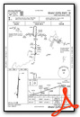
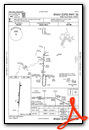
Nearby Airports with Instrument Procedures
| ID | Name | Heading / Distance | ||
|---|---|---|---|---|
 |
KPBH | Price County Airport | 176° | 14.8 |
|
D25 | Manitowish Waters Airport | 066° | 24.7 |
|
KARV | Lakeland/Noble F Lee Memorial Field Airport | 092° | 29.1 |
|
KIWD | Gogebic/Iron County Airport | 019° | 36.5 |
|
KRCX | Rusk County Airport | 221° | 36.6 |
|
3CU | Cable Union Airport | 292° | 37.3 |
|
KTKV | Tomahawk Regional Airport | 137° | 39.1 |
|
KASX | John F Kennedy Memorial Airport | 330° | 41.1 |
|
KHYR | Sawyer County Airport | 276° | 42.9 |
|
KRHI | Rhinelander/Oneida County Airport | 115° | 44.7 |
|
KEGV | Eagle River Union Airport | 091° | 48.4 |
|
KMDZ | Taylor County Airport | 174° | 51.5 |
Airport Images
Do you have a recent image of this airport? Upload it here!


