Login
Register


D95
Dupont/Lapeer Airport
Official FAA Data Effective 2026-01-22 0901Z
Chart Supplement

VFR Chart of D95
Sectional Charts at SkyVector.com
IFR Chart of D95
Enroute Charts at SkyVector.com
Location Information for D95
Coordinates: N43°3.99' / W83°16.29'Located 02 miles NE of Lapeer, Michigan on 255 acres of land. View all Airports in Michigan.
Surveyed Elevation is 834 feet MSL.
Operations Data
|
|
Airport Communications
| AWOS-3P: | 134.050 Tel. 810-664-5038 |
|---|---|
| GREAT LAKES APPROACH: | 118.8 257.9 |
| GREAT LAKES DEPARTURE: | 118.8 257.9 |
| UNICOM: | 123.000 |
| CTAF: | 123.000 |
| ATIS at FNT (21.6 W): | 133.15 |
| ASOS at FNT (22.0 W): | 810-202-2914 |
| AWOS-3 at CFS (24.8 N): | 119.275 989-672-4182 |
- APCH/DEP SVC PRVDD BY CLEVELAND ARTCC (ZOB) ON FREQS 126.75/348.75 (FLINT RCAG) WHEN GREAT LAKES APCH CTL CLSD.
- APCH/DEP & CLEARANCE DELIVERY NOT AVBL ON THE GROUND.
Nearby Navigation Aids
|
| ||||||||||||||||||||||||||||||||||||||||||||||||


Runway 18/36
| Dimensions: | 3800 x 75 feet / 1158 x 23 meters | |
|---|---|---|
| Surface: | Asphalt in Fair Condition | |
| Edge Lighting: | Medium Intensity | |
| Runway 18 | Runway 36 | |
| Coordinates: | N43°4.34' / W83°16.35' | N43°3.71' / W83°16.31' |
| Elevation: | 834.5 | 829.3 |
| Traffic Pattern: | Left | Left |
| Runway Heading: | 177° True | 357° True |
| Markings: | Non-Precision Instrument in good condition. | Non-Precision Instrument in good condition. |
| Glide Slope Indicator | P4L (4.00° Glide Path Angle) | P2L (4.00° Glide Path Angle) |
| REIL: | Yes | Yes |
Runway 09/27
CLSD NOV-APR & WHEN SNOW COVD. | ||
| Dimensions: | 1879 x 150 feet / 573 x 46 meters | |
|---|---|---|
| Surface: | Turf in Fair Condition | |
| Runway 09 | Runway 27 | |
| Coordinates: | N43°3.91' / W83°16.42' | N43°3.93' / W83°16.00' |
| Elevation: | 829.6 | 828.0 |
| Traffic Pattern: | Left | Left |
| Runway Heading: | 88° True | 268° True |
| Displaced Threshold: | 488 Feet | |
| Obstacles: | 14 ft Road 0 ft from runway, 125 ft right of center CTLNG OBSTN EXCEEDS A 45 DEG SLP. RWY 09 APCH RATIO 20:1 TO DTHR. |
13 ft Trees 0 ft from runway, 125 ft right of center CTLNG OBSTN EXCEEDS A 45 DEG SLP. |
Services Available
| Fuel: | 100LL (blue), Jet A+ |
|---|---|
| Transient Storage: | Hangars,Tiedowns CTC AMGR FOR HGR AVBLTY. |
| Airframe Repair: | NONE |
| Engine Repair: | NONE |
| Bottled Oxygen: | NONE |
| Bulk Oxygen: | NONE |
Ownership Information
| Ownership: | Publicly owned | |
|---|---|---|
| Owner: | MAYFIELD TWP | |
| 1900 N SAGINAW RD | ||
| LAPEER, MI 48446-7785 | ||
| 810-664-0821 | ||
| Manager: | JOHN M LEWIS | |
| 1232 ROODS LAKE RD | ||
| LAPEER, MI 48446-7785 | ||
| 810-441-4396 | ||
Other Remarks
- FOR CD CTC GREAT LAKES APCH AT 269-459-3345, WHEN APCH CLSD CTC CLEVELAND ARTCC AT 440-774-0224/0490.
- DEER & LRG BIRDS ON & INVOF ARPT.
- 26 FT MKD PLINE, 750 FT FM RWY END 36, 180 FT LEFT & RIGHT OF EXTDD CNTRLN.
- RWY 09/27 RWY & DTHR MKD WITH 3 FT YELLOW CONES.
- 3 FT YELLOW CONES.
- ACTVT REIL RWY 18 & 36; PAPI RWY 18 & 36; MIRL RWY 18/36 - CTAF.
Weather Minimums

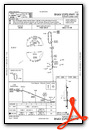
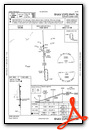
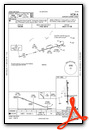
Instrument Approach Procedure (IAP) Charts
Nearby Airports with Instrument Procedures
| ID | Name | Heading / Distance | ||
|---|---|---|---|---|
 |
77G | Marlette Township Airport | 028° | 16.7 |
|
D98 | Romeo State Airport | 140° | 20.8 |
|
KFNT | Bishop International Airport | 253° | 21.7 |
|
KCFS | Tuscola Area Airport | 342° | 24.7 |
|
KPTK | Oakland County International Airport | 195° | 24.9 |
|
57D | Ray Community Airport | 139° | 26.0 |
|
9G2 | Prices Airport | 234° | 26.9 |
|
Y83 | Sandusky City Airport | 038° | 30.0 |
|
KVLL | Oakland/Troy Airport | 172° | 31.7 |
|
KMTC | Selfridge Angb Airport | 144° | 33.2 |
|
KPHN | St Clair County International Airport | 105° | 34.0 |
|
KHYX | Saginaw County/H W Browne Airport | 310° | 34.0 |
Airport Images

By: Volumex

By: sunmanav8


