Login
Register


CFS
Tuscola Area Airport
Official FAA Data Effective 2026-01-22 0901Z
Chart Supplement

VFR Chart of KCFS
Sectional Charts at SkyVector.com
IFR Chart of KCFS
Enroute Charts at SkyVector.com
Location Information for KCFS
Coordinates: N43°27.53' / W83°26.73'Located 03 miles SW of Caro, Michigan on 260 acres of land. View all Airports in Michigan.
Surveyed Elevation is 704 feet MSL.
Operations Data
|
|
Airport Communications
| AWOS-3: | 119.275 Tel. 989-672-4182 |
|---|---|
| GREAT LAKES APPROACH: | 120.95 235.625 |
| GREAT LAKES DEPARTURE: | 120.95 235.625 |
| CTAF: | 123.000 |
| UNICOM: | 123.000 |
| AWOS-3PT at HYX (18.4 W): | 118.325 989-752-3408 |
| AWOS-3P at D95 (24.8 S): | 134.050 810-664-5038 |
| AWOS-3 at BAX (27.8 NE): | 118.6 989-269-4137 |
- APCH/DEP SVC PRVDD BY CLEVELAND ARTCC (ZOB) ON FREQS 127.7/290.425 (FREELAND RCAG) WHEN GREAT LAKES APCH CTL CLSD.
Nearby Navigation Aids
|
| ||||||||||||||||||||||||||||||||||||||||||||||||


Runway 06/24
| Dimensions: | 4302 x 75 feet / 1311 x 23 meters | |
|---|---|---|
| Surface: | Asphalt in Excellent Condition | |
| Edge Lighting: | Medium Intensity | |
| Runway 06 | Runway 24 | |
| Coordinates: | N43°27.24' / W83°27.22' | N43°27.69' / W83°26.47' |
| Elevation: | 684.8 | 700.5 |
| Traffic Pattern: | Left | Left |
| Runway Heading: | 50° True | 230° True |
| Markings: | Non-Precision Instrument in good condition. | Non-Precision Instrument in good condition. |
| Glide Slope Indicator | P4L (3.00° Glide Path Angle) PAPI UNUSBL BYD 9 DEGS LEFT OF CNTRLN. | P4L (3.50° Glide Path Angle) |
| Obstacles: | 60 ft Tree 1215 ft from runway, 265 ft right of center | 48 ft Tree 793 ft from runway, 300 ft right of center |
Runway 13/31
| Dimensions: | 2277 x 110 feet / 694 x 34 meters | |
|---|---|---|
| Surface: | Turf in Fair Condition | |
| Runway 13 | Runway 31 | |
| Coordinates: | N43°27.74' / W83°26.72' | N43°27.56' / W83°26.28' |
| Elevation: | 704.3 | 689.0 |
| Traffic Pattern: | Left | Left |
| Runway Heading: | 120° True | 300° True |
| Displaced Threshold: | 564 Feet | |
| Obstacles: | 1 ft Brush 0 ft from runway, 125 ft right of center CTLNG OBSTN EXCEEDS A 45 DEG SLP. |
78 ft Tree 1054 ft from runway, 40 ft right of center APCH RATIO 20:1 TO DTHR. |
Services Available
| Fuel: | 100LL (blue), Jet A+ |
|---|---|
| Transient Storage: | Hangars,Tiedowns |
| Airframe Repair: | MAJOR |
| Engine Repair: | MAJOR |
| Bottled Oxygen: | NONE |
| Bulk Oxygen: | NONE |
Ownership Information
| Ownership: | Publicly owned | |
|---|---|---|
| Owner: | TUSCOLA AREA AIRPORT AUTHORITY | |
| 1750 SPEIRS RD | ||
| CARO, MI 48723-8211 | ||
| 989-673-4301 | ||
| Manager: | JOE GREENE | |
| 1750 SPEIRS RD | ||
| CARO, MI 48723-8211 | ||
| 989-670-2441 | ||
Other Remarks
- DEER & LRG BIRDS ON & INVOF ARPT.
- RC ACFT OPS S OF RWY INT.
- FOR CD CTC GREAT LAKES APCH AT 269-459-3345, WHEN APCH CLSD CTC CLEVELAND ARTCC AT 440-774-0224/0490.
- 3 FT YELLOW CONES.
- ACTVT PAPI RWY 06 & 24; MIRL RWY 06/24 - CTAF. PAPI RWY 06 & 24 OPR CONSLY DAWN-DUSK.
Weather Minimums

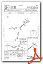
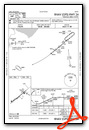
Instrument Approach Procedure (IAP) Charts

Nearby Airports with Instrument Procedures
| ID | Name | Heading / Distance | ||
|---|---|---|---|---|
 |
77G | Marlette Township Airport | 119° | 17.8 |
|
KHYX | Saginaw County/H W Browne Airport | 265° | 18.3 |
|
3CM | James Clements Municipal Airport | 285° | 20.3 |
|
D95 | Dupont/Lapeer Airport | 161° | 24.7 |
|
Y83 | Sandusky City Airport | 090° | 26.4 |
|
KBAX | Huron County Memorial Airport | 045° | 27.8 |
|
KMBS | Mbs International Airport | 279° | 28.1 |
|
KFNT | Bishop International Airport | 204° | 32.4 |
|
KIKW | Jack Barstow Airport | 289° | 37.6 |
|
KRNP | Owosso Community Airport | 227° | 41.3 |
|
9G2 | Prices Airport | 200° | 41.6 |
|
D98 | Romeo State Airport | 152° | 44.8 |
Airport Images

By: sunmanav8


