Login
Register


I69
Clermont County Airport
Official FAA Data Effective 2026-02-19 0901Z
Chart Supplement

VFR Chart of I69
Sectional Charts at SkyVector.com
IFR Chart of I69
Enroute Charts at SkyVector.com
Location Information for I69
Coordinates: N39°4.70' / W84°12.61'Located 02 miles W of Batavia, Ohio on 60 acres of land. View all Airports in Ohio.
Surveyed Elevation is 843 feet MSL.
Operations Data
|
|
Airport Communications
| AWOS-3: | 127.275 Tel. 513-732-6978 |
|---|---|
| CINCINNATI APPROACH: | 121.0 254.25 |
| CINCINNATI DEPARTURE: | 121.0 254.25 |
| CLEARANCE DELIVERY: | 124.9 |
| UNICOM: | 122.975 |
| CTAF: | 122.975 |
| CINCE STAR: | 254.25 |
| ASOS at LUK (9.7 W): | 513-321-6291 |
| ATIS at LUK (9.8 W): | 123.6 |
| D-ATIS at CVG (21.4 W): | 135.3 ;DEP |
Nearby Navigation Aids
|
| ||||||||||||||||||||||||||||||||||||||||||||||||||||||||||||


Runway 04/22
| Dimensions: | 3567 x 75 feet / 1087 x 23 meters | |
|---|---|---|
| Surface: | Asphalt in Fair Condition | |
| Edge Lighting: | Medium Intensity | |
| Runway 04 | Runway 22 | |
| Coordinates: | N39°4.47' / W84°12.84' | N39°4.94' / W84°12.39' |
| Elevation: | 843.5 | 812.9 |
| Traffic Pattern: | Left | Left |
| Runway Heading: | 36° True | 216° True |
| Displaced Threshold: | 395 Feet | |
| Markings: | Non-Precision Instrument in fair condition. | Non-Precision Instrument in fair condition. |
| Glide Slope Indicator | P2L (4.00° Glide Path Angle) | P2L (3.00° Glide Path Angle) |
| REIL: | Yes | Yes |
| Obstacles: | 12 ft Road 201 ft from runway, 225 ft right of center 0:1 APCH SLP TO DTHR OVR 12 FT ROAD, 225 FT R. CLOSE-IN OBSTNS INCL FENCES & ROADS. |
75 ft Trees 1350 ft from runway, 410 ft right of center CLOSE-IN OBSTNS INCL CONC PIPE & FENCE. |
Services Available
| Fuel: | 100LL (blue), Jet-A |
|---|---|
| Transient Storage: | Hangars,Tiedowns PRIOR CDN RQRD FOR TSNT HNGR. |
| Airframe Repair: | MAJOR |
| Engine Repair: | MAJOR |
| Bottled Oxygen: | NONE |
| Bulk Oxygen: | NONE |
| Other Services: | AVIONICS,PILOT INSTRUCTION,AIRCRAFT RENTAL,AIRCRAFT SALES |
Ownership Information
| Ownership: | Publicly owned | |
|---|---|---|
| Owner: | CLERMONT CO COMSNRS | |
| 101 E MAIN ST | ||
| BATAVIA, OH 45103-2957 | ||
| 513-735-9500 | ||
| Manager: | CHUCK GALLAGHER | |
| 2001 SPORTYS DR | ||
| BATAVIA, OH 45103-9719 | ||
| 513-735-9100 | EXTN 227. | |
Other Remarks
- TAXI ON HARD SFC ONLY.
- DEER, BIRDS, & OTR WILDLIFE ON & INVOF ARPT.
- FOR CD CTC CINCINNATI APCH AT 859-372-6440.
- ICING INHIBITOR AVBL BY INJECTION.
- PRIOR CDN RQRD FOR TSNT TIEDOWN.
- ACTVT REIL RWY 04 & 22; PAPI RWY 04 & 22; MIRL RWY 04/22 - CTAF.
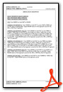
Weather Minimums

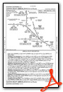
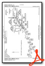
Standard Terminal Arrival (STAR) Charts


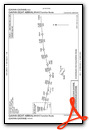

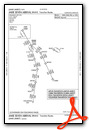


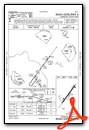
Instrument Approach Procedure (IAP) Charts

Nearby Airports with Instrument Procedures
| ID | Name | Heading / Distance | ||
|---|---|---|---|---|
 |
KLUK | Cincinnati Municipal/Lunken Field Airport | 278° | 9.8 |
|
KGEO | Brown County Airport | 127° | 19.3 |
|
KCVG | Cincinnati/Northern Kentucky International Airport | 265° | 21.5 |
|
KHAO | Butler County Regional/Hogan Field Airport | 319° | 22.4 |
|
I68 | Warren County/John Lane Field Airport | 355° | 23.1 |
|
K62 | Gene Snyder Airport | 200° | 24.0 |
|
I67 | Cincinnati West Airport | 292° | 28.5 |
|
KMWO | Middletown Regional/Hook Field Airport | 342° | 28.5 |
|
KILN | Wilmington Air Park Airport | 042° | 28.6 |
|
I66 | Clinton Field Airport | 032° | 30.1 |
|
KMGY | Dayton/Wright Brothers Airport | 358° | 30.6 |
|
KHOC | Highland County Airport | 077° | 32.0 |
Airport Images
Do you have a recent image of this airport? Upload it here!


