Login
Register


LUK
Cincinnati Municipal/Lunken Field Airport
Official FAA Data Effective 2026-01-22 0901Z
Chart Supplement

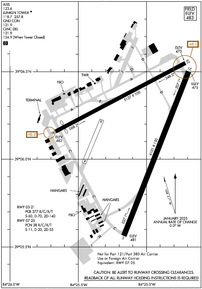
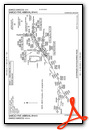
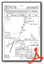
KLUK Airport Diagram
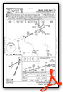
VFR Chart of KLUK
Sectional Charts at SkyVector.com
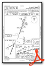
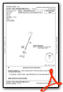
IFR Chart of KLUK
Enroute Charts at SkyVector.com
Location Information for KLUK
Coordinates: N39°6.18' / W84°25.06'Located 03 miles SE of Cincinnati, Ohio on 1140 acres of land. View all Airports in Ohio.
Surveyed Elevation is 481 feet MSL.
Operations Data
|
|
Airport Communications
| ATIS: | 123.6 |
|---|---|
| ASOS: | Tel. 513-321-6291 |
| LUNKEN TOWER: | 118.7 257.8 |
| LUNKEN GROUND: | 121.9 |
| CINCINNATI APPROACH: | 121.0 254.25 |
| CINCINNATI DEPARTURE: | 121.0 254.25 |
| CLEARANCE DELIVERY: | 121.9 124.9 ;WHEN LUK TWR CLSD |
| CTAF: | 118.700 |
| UNICOM: | 122.950 |
| CINCE STAR: | 254.25 |
| AWOS-3 at I69 (9.9 E): | 127.275 513-732-6978 |
| D-ATIS at CVG (12.1 W): | 135.3 ;DEP |
| ASOS at CVG (12.4 W): | 134.375 859-414-0353 |
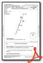
Nearby Navigation Aids
|
| ||||||||||||||||||||||||||||||||||||||||||||||||||||||||||||


Runway 03/21
| Dimensions: | 6101 x 150 feet / 1860 x 46 meters | |
|---|---|---|
| Surface: | Asphalt / Grooved in Excellent Condition | |
| Weight Limits: | S-60, D-70, ST-140
PCR VALUE: 377/R/C/X/T
| |
| Edge Lighting: | High Intensity | |
| Runway 03 | Runway 21 | |
| Coordinates: | N39°5.56' / W84°25.17' | N39°6.50' / W84°24.71' |
| Elevation: | 481.1 | 475.1 |
| Traffic Pattern: | Left | Left |
| Runway Heading: | 21° True | 201° True |
| Declared Distances: | TORA:6101 TODA:6101 ASDA:6101 LDA:6101 | TORA:6101 TODA:6101 ASDA:6101 LDA:6101 |
| Markings: | Non-Precision Instrument in good condition. | Precision Instrument in good condition. |
| Glide Slope Indicator | P4R (3.00° Glide Path Angle) PAPI UNUSBL BYD 7 DEGS LEFT OF CNTRLN. | P4L (3.00° Glide Path Angle) |
| RVR Equipment | Rollout | Touchdown |
| Approach Lights: | MALSR 1,400 Foot Medium-intensity Approach Lighting System with runway alignment indicator lights. | |
| REIL: | Yes | |
| Obstacles: | 106 ft Tree 2094 ft from runway, 734 ft right of center | 47 ft Tree 962 ft from runway, 605 ft right of center |
Runway 07/25
RWY 07/25 NOT AVBL FOR PART 121/PART 380 OPS WITH SKED PAX CARRYING OPS MORE THAN 9 PAX SEATS AND NON-SKED PAX CARRYING OPS MORE THAN 30 PAX SEATS. | ||
| Dimensions: | 5127 x 100 feet / 1563 x 30 meters | |
|---|---|---|
| Surface: | Asphalt / Grooved in Fair Condition | |
| Weight Limits: | 38 /R/C/X/T, S-11, D-20, ST-55 | |
| Edge Lighting: | Medium Intensity | |
| Runway 07 | Runway 25 | |
| Coordinates: | N39°6.16' / W84°25.68' | N39°6.55' / W84°24.72' |
| Elevation: | 481.5 | 474.9 |
| Traffic Pattern: | Left | Left |
| Runway Heading: | 62° True | 242° True |
| Displaced Threshold: | 439 Feet | |
| Markings: | Non-Precision Instrument in fair condition. | Non-Precision Instrument in fair condition. |
| Glide Slope Indicator | V4L (3.00° Glide Path Angle) | |
| Obstacles: | 30 ft Building 210 ft from runway, 167 ft right of center CTLG OBSTN EXCEEDS A 45 DEG SLP. +35 FT HNGR, 615 FT DIST, 157 FT R, APCH RATIO 19:1 TO DTHR. |
57 ft Tree 1261 ft from runway, 254 ft right of center |
Services Available
| Fuel: | 100LL (blue), Jet A+ |
|---|---|
| Transient Storage: | Tiedowns |
| Airframe Repair: | MAJOR |
| Engine Repair: | MAJOR |
| Bottled Oxygen: | NOT AVAILABLE |
| Bulk Oxygen: | HIGH |
| Other Services: | AIR AMBULANCE SERVICES,AVIONICS,CHARTER SERVICE,PILOT INSTRUCTION,AIRCRAFT SALES |
Ownership Information
| Ownership: | Publicly owned | |
|---|---|---|
| Owner: | CITY OF CINCINNATI | |
| 465 WILMER AVE | ||
| CINCINNATI, OH 45226-1833 | ||
| 513-321-4132 | ||
| Manager: | JAIME EDROSA | |
| 465 WILMER AVE | ||
| CINCINNATI, OH 45226-1833 | ||
| 513-352-6340 | ||
Other Remarks
- DEER & BIRDS ON & INVOF ARPT.
- CUST IN TEMPO FAC; CUST FAC REQS MUST BE SMTD TO ARPT FIRST BY CALLING 513-709-2761 OR EMAIL #DOTE-AVIATION@CINCINNATI-OH.GOV.
- CLSD TO SKEDD ACR OPS GTR THAN 9 PAX SEATS. 48 HR PPR FOR UNSKED ACR OPS WITH GTR THAN 30 PAX SEATS CALL AMGR.
- NOISE ABATEMENT PROCS IN EFCT CALL AMGR. ACFT MAINT RUNUPS RSTRD BTN 2100-0700.
- AER 25 & 21 ARE CLOSELY LCTD; VFY COR RWY WITH COMPASS HDG BFR DEP.
- TWY D, E, G, & H CLSD TO UNSKED ACR OPS GTR THAN 30 PAX SEATS.
- ARPT SFC COND UNMON DLY 2300-0700.
- TWY H NOT VSB FM ATCT, CTC GC. WHEN ATCT CLSD, USE CTAF.
- A+ C513-871-2020.
- WHEN ATCT CLSD ACTVT OR INCR INTST MALSR RWY 21; HIRL RWY 03/21 - CTAF. HIRL RWY 03/21 PRESET MED INTST. RWY 07/25 PCL UNAVBL.
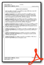
Weather Minimums


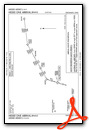
Standard Terminal Arrival (STAR) Charts


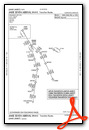
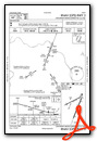
Instrument Approach Procedure (IAP) Charts
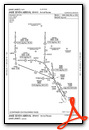
Departure Procedure (DP) Charts
Nearby Airports with Instrument Procedures
| ID | Name | Heading / Distance | ||
|---|---|---|---|---|
 |
I69 | Clermont County Airport | 098° | 9.8 |
|
KCVG | Cincinnati/Northern Kentucky International Airport | 254° | 12.1 |
|
KHAO | Butler County Regional/Hogan Field Airport | 342° | 16.4 |
|
I67 | Cincinnati West Airport | 299° | 19.1 |
|
I68 | Warren County/John Lane Field Airport | 019° | 22.9 |
|
K62 | Gene Snyder Airport | 177° | 23.9 |
|
KMWO | Middletown Regional/Hook Field Airport | 002° | 25.7 |
|
KGEO | Brown County Airport | 117° | 28.3 |
|
KOXD | Miami University Airport | 324° | 29.4 |
|
KMGY | Dayton/Wright Brothers Airport | 017° | 30.5 |
|
KILN | Wilmington Air Park Airport | 056° | 35.1 |
|
I66 | Clinton Field Airport | 046° | 35.2 |
Fuel Providers

Airport Images
Do you have a recent image of this airport? Upload it here!


