Login
Register
IL45
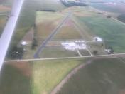
Palmer Flying Service Inc Airport
Official FAA Data Effective 2025-11-27 0901Z
VFR Chart of IL45
Sectional Charts at SkyVector.com
IFR Chart of IL45
Enroute Charts at SkyVector.com
Location Information for IL45
Coordinates: N40°29.36' / W89°46.68'Located 03 miles N of Manito, Illinois on 80 acres of land. View all Airports in Illinois.
Surveyed Elevation is 501 feet MSL.
Operations Data
|
|
Airport Communications
| ATIS at PIA (11.2 N): | 126.1 |
|---|---|
| ASOS at PIA (11.2 N): | 309-322-3740 |
| AWOS-3 at AAA (28.4 SE): | 118.775 217-732-9605 |
Nearby Navigation Aids
|
| ||||||||||||||||||||||||||||||||||||||||||||||||||||||||||||
Runway 04/22
| Dimensions: | 2784 x 40 feet / 849 x 12 meters | |
|---|---|---|
| Surface: | Asphalt in Fair Condition | |
| Edge Lighting: | Non-Standard NSTD LIRL BTN DSPLCD THLDS; FIXTURE SPACING & LGT INTST VARIES. | |
| Runway 04 | Runway 22 | |
| Coordinates: | N40°29.17' / W89°46.77' | N40°29.58' / W89°46.51' |
| Elevation: | 495.0 | 501.0 |
| Traffic Pattern: | Left | Left |
| Runway Heading: | 25° True | 205° True |
| Displaced Threshold: | 175 Feet | 448 Feet |
| Markings: | None | None |
| Obstacles: | 58 ft Tree 1134 ft from runway, 250 ft right of center APCH RATIO TO DSPLCD THR IS 22:1. |
31 ft Pole 213 ft from runway, 150 ft left of center APCH RATIO TO DSPLCD THR IS 21:1; APCH RATIO TO DSPLCD THR OVER 47' TREE 30' FM RY END IS 2:1. NUMEROUS TREES; POLES & BLDG WITH MAX TOPS 75' 182' L OF CNTRLN 466' FM DSPLCD THR. |
Runway 18/36
| Dimensions: | 2188 x 40 feet / 667 x 12 meters RWY 18/36 895 FT BY 40 FT ASPH STRIP SUPERIMPOSED ON N END OF RWY. | |
|---|---|---|
| Surface: | Asphalt-Turf in Poor Condition GRASS GROWING THRU CRACKS IN BLACKTOP. | |
| Runway 18 | Runway 36 | |
| Coordinates: | N40°29.52' / W89°46.74' | N40°29.16' / W89°46.74' |
| Elevation: | 496.0 | 495.0 |
| Traffic Pattern: | Left | Left |
| Runway Heading: | 180° True | 360° True |
| Displaced Threshold: | 700 Feet | 80 Feet |
| Markings: | None | None |
| Obstacles: | 57 ft Tree 631 ft from runway, 149 ft right of center RY 18 APCH RATIO IS CALCULATED TO THE DSPLCD THLD NOT THE RY END AS PER PHOTO SLOPE DATED 10/23/97. |
82 ft Tree 1335 ft from runway, 258 ft left of center RY 36 APCH RATIO TO DSPLCD THR IS 17:1. |
Services Available
| Fuel: | NONE |
|---|---|
| Transient Storage: | Tiedowns |
| Airframe Repair: | NOT AVAILABLE |
| Engine Repair: | NOT AVAILABLE |
| Bottled Oxygen: | NONE |
| Bulk Oxygen: | NONE |
| Other Services: | CROP DUSTING SERVICES |
Ownership Information
| Ownership: | Privately Owned | |
|---|---|---|
| Owner: | PALMER FLYING SERVICE | |
| 7757 AIRPORT RD | ||
| MANITO, IL 61546 | ||
| 309-545-2281 | ||
| Manager: | KEVIN PALMER | |
| 7757 AIRPORT RD | ||
| MANITO, IL 61546 | ||
| 309-253-2128 | ||
Other Remarks
- THIS AIRPORT HAS BEEN SURVEYED BY THE NATIONAL GEODETIC SURVEY.
- ACFT TAKING OFF ON RY 36 CANNOT SEE AER 22 WHEN CROPS GROW HIGH.
- (A42) ALL DSPLCD THRS MKD WITH WHITE TIRES.
- FOR CD CTC ST LOUIS APCH AT 314-890-1017.
- FOR NSTD LIRL RY 04/22 CALL 309-545-2281 - AFTER DARK OR EMERGENCY.
Nearby Airports with Instrument Procedures
| ID | Name | Heading / Distance | ||
|---|---|---|---|---|
 |
C15 | Pekin Municipal Airport | 090° | 4.7 |
 |
KPIA | General Downing - Peoria International Airport | 020° | 11.2 |
 |
KCTK | Ingersoll Airport | 289° | 14.4 |
 |
3MY | Mount Hawley Auxiliary Airport | 022° | 19.9 |
 |
KAAA | Logan County Airport | 134° | 28.4 |
 |
C75 | Marshall County Airport | 029° | 36.4 |
 |
KSPI | Abraham Lincoln Capital Airport | 173° | 38.9 |
 |
KBMI | Central Il Regional/Bloomington-Normal Airport | 090° | 39.5 |
 |
KMQB | Macomb Municipal Airport | 272° | 40.1 |
 |
KGBG | Harrel W Timmons Galesburg Regional Airport | 312° | 40.1 |
 |
KEZI | Kewanee Municipal Airport | 348° | 43.7 |
 |
C66 | Monmouth Municipal Airport | 304° | 47.0 |


