Login
Register


JPX
East Hampton Town Airport
Official FAA Data Effective 2026-01-22 0901Z
Chart Supplement

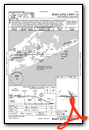
VFR Chart of KJPX
Sectional Charts at SkyVector.com
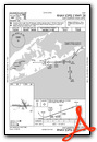
IFR Chart of KJPX
Enroute Charts at SkyVector.com
Location Information for KJPX
Coordinates: N40°57.57' / W72°15.10'Located 03 miles W of East Hampton, New York on 570 acres of land. View all Airports in New York.
Surveyed Elevation is 54 feet MSL.
Operations Data
|
|
Airport Communications
| AWOS-3PT: | 118.075 Tel. 631-537-2527 |
|---|---|
| EAST HAMPTON TOWER: | 125.225 |
| EAST HAMPTON GROUND: | 121.9 |
| NEW YORK APPROACH: | 125.975 343.65 |
| NEW YORK DEPARTURE: | 125.975 343.65 |
| CLEARANCE DELIVERY: | 118.95 |
| CTAF: | 125.225 |
| ASOS at FOK (17.9 W): | 119.925 631-288-0588 |
| ASOS at GON (24.1 NE): | 127.0 860-449-8921 |
| ATIS at GON (24.1 NE): | 127.0 |
Nearby Navigation Aids
|
| ||||||||||||||||||||||||||||||||||||||||||||||||||||||||||||


Runway 10/28
| Dimensions: | 4255 x 100 feet / 1297 x 30 meters | |
|---|---|---|
| Surface: | Asphalt / Grooved in Good Condition | |
| Weight Limits: | S-78 | |
| Edge Lighting: | Medium Intensity | |
| Runway 10 | Runway 28 | |
| Coordinates: | N40°57.53' / W72°15.62' | N40°57.55' / W72°14.69' |
| Elevation: | 54.9 | 30.2 |
| Runway Heading: | 89° True | 269° True |
| Markings: | Non-Precision Instrument in good condition. | Non-Precision Instrument in good condition. |
| Glide Slope Indicator | P2L (3.30° Glide Path Angle) | P2R (3.80° Glide Path Angle) |
| REIL: | Yes | Yes |
| Obstacles: | 75 ft Trees 1359 ft from runway, 20 ft right of center | 48 ft Pole 282 ft from runway, 254 ft right of center +78 FT TREES, 850 FT FM THR BOTH SIDES CNTRLN; +15 FT ROAD, 491 FT FM THR BOTH SIDES CNTRLN. |
Runway 16/34
| Dimensions: | 2060 x 75 feet / 628 x 23 meters | |
|---|---|---|
| Surface: | Asphalt in Fair Condition | |
| Weight Limits: | S-8 | |
| Runway 16 | Runway 34 | |
| Coordinates: | N40°57.76' / W72°15.10' | N40°57.47' / W72°14.87' |
| Elevation: | 40.7 | 29.8 |
| Runway Heading: | 149° True | 329° True |
| Markings: | Basic in fair condition. | Basic in fair condition. |
| Obstacles: | 15 ft Road 245 ft from runway | 45 ft Trees 699 ft from runway |
Services Available
| Fuel: | 100LL (blue), Jet-A |
|---|---|
| Transient Storage: | Hangars,Tiedowns |
| Airframe Repair: | MAJOR |
| Engine Repair: | MAJOR |
| Bottled Oxygen: | NONE |
| Bulk Oxygen: | NONE |
| Other Services: | CHARTER SERVICE,PILOT INSTRUCTION |
Ownership Information
| Ownership: | Publicly owned | |
|---|---|---|
| Owner: | TOWN OF EAST HAMPTON | |
| 159 PANTIGO RD | ||
| EAST HAMPTON, NY 11937 | ||
| 631-324-4140 | ||
| Manager: | JAMES BRUNDIGE | |
| 173 DANIELS HOLD RD | ||
| WAINSCOTT, NY 11975 | ||
| 631-537-1130 | EXT 5. | |
Other Remarks
- DEER ON & INVOF ARPT.
- REFER TO ARPT WEBSITE FOR DTLS ON CURRENT ARPT USAGE, RULES, NOISE ABMNT PCDRS AND REGS PRIOR TO ARR.
- FOR CD WHEN ATCT CLSD CTC NEW YORK APCH AT 516-683-2449.
- CTC FBO ON 122.85 FOR RAMP SVCS & PRKG.
- ACTVT REIL RWY 28, MIRL RWY 10/28, TWY LGTS - CTAF. REIL RWY 10; PAPI RWY 10 & 28 OPR CONSLY.
Weather Minimums
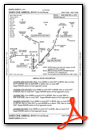
Standard Terminal Arrival (STAR) Charts
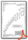
Instrument Approach Procedure (IAP) Charts
Nearby Airports with Instrument Procedures
| ID | Name | Heading / Distance | ||
|---|---|---|---|---|
 |
87N | Southampton Heliport | 235° | 11.9 |
 |
KMTP | Montauk Airport | 064° | 16.6 |
|
KFOK | Francis S Gabreski Airport | 248° | 18.6 |
|
0B8 | Elizabeth Field Airport | 029° | 20.2 |
|
KGON | Groton-New London Airport | 022° | 24.1 |
|
KSNC | Chester Airport | 335° | 27.9 |
|
KHWV | Brookhaven Airport | 253° | 29.2 |
|
KWST | Westerly State Airport | 040° | 31.0 |
|
KBID | Block Island State Airport | 067° | 33.0 |
|
KHVN | Tweed/New Haven Airport | 302° | 34.1 |
|
KISP | Long Island Mac Arthur Airport | 256° | 39.9 |
|
KBDR | Bridgeport/Sikorsky Airport | 287° | 41.5 |
Airport Images

By: N1888E-young


