Login
Register


K64
Vinland Valley Aerodrome Airport
Official FAA Data Effective 2025-12-25 0901Z
Chart Supplement

VFR Chart of K64
Sectional Charts at SkyVector.com
IFR Chart of K64
Enroute Charts at SkyVector.com
Location Information for K64
Coordinates: N38°50.17' / W95°10.92'Located 03 miles N of Baldwin City, Kansas on 23 acres of land. View all Airports in Kansas.
Estimated Elevation is 890 feet MSL.
Operations Data
|
|
Airport Communications
| CTAF: | 122.900 |
|---|---|
| ASOS at LWC (10.6 N): | 121.225 785-749-1309 |
| ASOS at IXD (13.6 E): | 135.325 913-780-6987 |
| AWOS-3PT at OWI (18.0 S): | 118.25 785-242-2185 |
Nearby Navigation Aids
|
| ||||||||||||||||||||||||||||||||||||||||||||||||||||||||||||


Runway 16/34
| Dimensions: | 3030 x 80 feet / 924 x 24 meters | |
|---|---|---|
| Surface: | Turf in Good Condition | |
| Edge Lighting: | Non-Standard NSTD LIRL. | |
| Runway 16 | Runway 34 | |
| Traffic Pattern: | Left | Left |
| Obstacles: | 35 ft Trees 368 ft from runway, 125 ft right of center | 40 ft Tree 612 ft from runway, 164 ft left of center |
Services Available
| Fuel: | 100LL (blue) |
|---|---|
| Transient Storage: | Tiedowns |
| Airframe Repair: | NOT AVAILABLE |
| Engine Repair: | NOT AVAILABLE |
| Bottled Oxygen: | NOT AVAILABLE |
| Bulk Oxygen: | NOT AVAILABLE |
| Other Services: | PILOT INSTRUCTION,AIRCRAFT RENTAL |
Ownership Information
| Ownership: | Privately Owned | |
|---|---|---|
| Owner: | K64 LLC | |
| 696 E. 1700 RD. | ||
| BALDWIN CITY, KS 66006 | ||
| 785-594-2741 | ||
| Manager: | DAVID MCFARLANE | |
| 696 E. 1700 RD | ||
| BALDWIN CITY, KS 66006 | ||
| 785-594-2741 | EXT 222. ALT NR: 785-248-3833. | |
Other Remarks
- TALL TREES L SIDE AER 16.
- PATTERN ALTITUDE: FIXED WING AIRCRAFT: 1690 MSL.
- FOR CD CTC KANSAS CITY ARTCC AT 913-254-8508.
- RWY 35 SEASONAL CROPS AER.
- 0LL FUEL ONLY AVBL ATND HRS OR BY PRIOR ARRANGEMENT.
- DUSK-DAWN. ACTVT LIRL RY 16/34 - CTAF 3 CLICKS
Nearby Airports with Instrument Procedures
| ID | Name | Heading / Distance | ||
|---|---|---|---|---|
 |
KLWC | Lawrence Regional Airport | 351° | 10.6 |
|
KIXD | New Century Aircenter Airport | 091° | 13.7 |
|
KOWI | Ottawa Municipal Airport | 190° | 18.1 |
|
KOJC | Johnson County Exec Airport | 087° | 20.8 |
|
K81 | Miami County Airport | 145° | 21.6 |
|
KFOE | Topeka Regional Airport | 287° | 23.6 |
|
KTOP | Philip Billard Municipal Airport | 304° | 24.9 |
|
KMKC | Kansas City Downtown/Wheeler Field Airport | 057° | 32.5 |
|
KFLV | Sherman AAF Airport | 021° | 34.2 |
|
KMCI | Kansas City International Airport | 038° | 35.3 |
|
KLXT | Kansas City/Lee's Summit Regional Airport | 078° | 38.7 |
|
KUKL | Coffey County Airport | 218° | 40.9 |
Airport Images
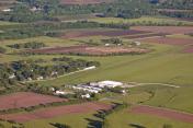
By: RedHarrell


