Login
Register


AGS
Augusta Regional At Bush Field Airport
Official FAA Data Effective 2026-01-22 0901Z
Chart Supplement

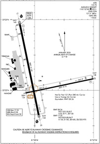
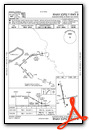
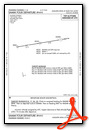
KAGS Airport Diagram
VFR Chart of KAGS
Sectional Charts at SkyVector.com
IFR Chart of KAGS
Enroute Charts at SkyVector.com
Location Information for KAGS
Coordinates: N33°22.20' / W81°57.87'Located 06 miles S of Augusta, Georgia on 1411 acres of land. View all Airports in Georgia.
Surveyed Elevation is 145 feet MSL.
Operations Data
|
|
Airport Communications
| ATIS: | 132.75 |
|---|---|
| ASOS: | Tel. 706-250-6089 |
| AUGUSTA TOWER: | 118.7 239.3 |
| AUGUSTA GROUND: | 121.9 348.6 |
| AUGUSTA APPROACH: | 119.15 ;350-169 126.8 ;170-349 270.3 ;170-349 284.625 ;350-169 |
| AUGUSTA DEPARTURE: | 119.15 ;350-169 126.8 ;170-349 270.3 ;170-349 284.625 ;350-169 |
| IC: | 126.8 ;170-349 270.3 ;170-349 |
| CLEARANCE DELIVERY: | 118.65 |
| CTAF: | 118.700 |
| STWRT STAR: | 119.15 284.625 |
| UNICOM: | 122.950 |
| STUGE STAR: | 119.15 284.625 |
| TRSA: | 119.15 ;350-169 126.8 ;170-349 270.3 ;170-349 284.625 ;350-169 |
| ARMY OPS: | 149.7 49.9FM |
| MEDEVAC: | 32.5FM |
| EMERG: | 121.5 243.0 |
| ASOS at DNL (6.9 NW): | 135.275 706-481-8629 |
| AWOS-3PT at AIK (22.0 NE): | 118.025 803-643-8664 |
| AWOS-3PT at 2J5 (28.7 S): | 120.2 478-982-4562 |
- APCH/DEP SVC PRVDD BY ATLANTA ARTCC ON FREQS 128.1/322.325 (AUGUSTA RCAG) WHEN APCH CTL CLSD.
Nearby Navigation Aids
|
| ||||||||||||||||||||||||||||||||||||||||||||||||||||||||||||


Runway 17/35
| Dimensions: | 8001 x 150 feet / 2439 x 46 meters | |
|---|---|---|
| Surface: | Concrete / Grooved in Good Condition | |
| Weight Limits: | S-155, D-160, ST-450, DT-975
2S-175.
2T-585K (B-C-17), 2D/2D2-975K (747), 840K (C-5) 2D/2D2-975K (747).
PCR VALUE: 930/R/B/W/T
| |
| Edge Lighting: | High Intensity | |
| Runway 17 | Runway 35 | |
| Coordinates: | N33°22.94' / W81°58.25' | N33°21.65' / W81°57.93' |
| Elevation: | 144.8 | 133.7 |
| Traffic Pattern: | Left | Left |
| Runway Heading: | 168° True | 348° True |
| Markings: | Precision Instrument in good condition. | Precision Instrument in good condition. |
| Glide Slope Indicator | P4L (3.00° Glide Path Angle) | P4L (3.00° Glide Path Angle) |
| RVR Equipment | Touchdown Rollout | Touchdown Rollout |
| Approach Lights: | MALSR 1,400 Foot Medium-intensity Approach Lighting System with runway alignment indicator lights. | MALSR 1,400 Foot Medium-intensity Approach Lighting System with runway alignment indicator lights. |
| Obstacles: | 90 ft Tree 2450 ft from runway, 800 ft left of center | 42 ft Trees 1500 ft from runway, 600 ft left of center PER SURVEY DEC 2004 RWY 17-35. |
Runway 08/26
RWY 08/26 NOT AVBL FOR PART 121/PART 380 OPS WITH SKED PAX CARRYING OPS MORE THAN 9 PAX SEATS AND NON-SKED PAX CARRYING OPS MORE THAN 30 PAX SEATS. | ||
| Dimensions: | 6001 x 75 feet / 1829 x 23 meters | |
|---|---|---|
| Surface: | Asphalt / Grooved in Good Condition | |
| Weight Limits: | S-52, D-71, ST-126
PCR VALUE: 120/F/B/X/T
| |
| Edge Lighting: | Medium Intensity | |
| Runway 08 | Runway 26 | |
| Coordinates: | N33°21.96' / W81°58.15' | N33°22.16' / W81°57.00' |
| Elevation: | 134.2 | 137.7 |
| Traffic Pattern: | Left | Left |
| Runway Heading: | 78° True | 258° True |
| Markings: | Non-Precision Instrument in good condition. | Non-Precision Instrument in good condition. |
| Glide Slope Indicator | P4L (3.00° Glide Path Angle) | P4L (3.00° Glide Path Angle) |
| REIL: | Yes | Yes |
| Obstacles: | 52 ft Trees 1250 ft from runway, 125 ft right of center | 65 ft Trees 1250 ft from runway, 200 ft left of center |
Services Available
| Fuel: | 100LL (blue), Jet-A |
|---|---|
| Transient Storage: | Hangars,Tiedowns |
| Airframe Repair: | MAJOR |
| Engine Repair: | MAJOR |
| Bottled Oxygen: | HIGH/LOW |
| Bulk Oxygen: | HIGH/LOW |
| Other Services: | AIR AMBULANCE SERVICES,AVIONICS,CARGO HANDLING SERVICES,CHARTER SERVICE,AIRCRAFT RENTAL,AIRCRAFT SALES |
Ownership Information
| Ownership: | Publicly owned | |
|---|---|---|
| Owner: | CITY OF AUGUSTA | |
| AVIATION DEPARTMENT, 1501 AVIATION WAY | ||
| AUGUSTA, GA 30906 | ||
| 706-798-2656 | ||
| Manager: | HERBERT JUDON | |
| 1501 AVIATION WAY | ||
| AUGUSTA, GA 30906 | ||
| 706-798-3236 | ||
Other Remarks
- BIRDS ON & INVOF ARPT. HVY BIRD ACT INVOF ARPT NOV-MAR.
- CAUTION: TAXI-LANE RAMP ENTRANCE/EXIT POINT INTO STANDARD AERO STORM WATER DITCH ON NORTH SIDE.
- CAUTION: WILDLIFE HAZARD COYOTE.
- FOR CD IF UNA TO CTC ON FSS FREQ, CTC AUGUSTA APCH AT 706-771-1777, WHEN APCH CLSD CTC ATLANTA ARTCC AT 770-210-7692.
- TWY ALL EAST OF RWY 17/35 CLSD TO AIR CARRIER ACFT.
- PAPI RWYS 08, 17, 26 & 35, OPER CONSLY. REIL RWY 08 & 26; MIRL RWY 08/26; HIRL RWY 17/35 OPER CONSLY WHEN ATCT CLSD. ACTVT MALSR RWY 17 & 35 - CTAF.
Weather Minimums

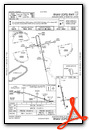
Standard Terminal Arrival (STAR) Charts

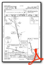
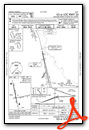
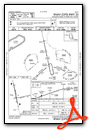
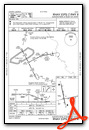
Instrument Approach Procedure (IAP) Charts
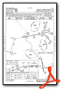
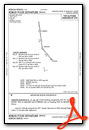
Departure Procedure (DP) Charts


Nearby Airports with Instrument Procedures
| ID | Name | Heading / Distance | ||
|---|---|---|---|---|
 |
KDNL | Daniel Field Airport | 326° | 6.9 |
|
KBXG | Burke County Airport | 185° | 19.8 |
|
KAIK | Aiken Regional Airport | 039° | 21.8 |
|
2J5 | Millen Airport | 180° | 28.6 |
|
KHQU | Thomson/Mcduffie County Airport | 289° | 29.3 |
|
KBNL | Barnwell Regional Airport | 102° | 29.7 |
|
2J3 | Louisville Municipal Airport | 222° | 31.3 |
|
6J4 | Saluda County Airport | 014° | 34.4 |
|
KAQX | Allendale County Airport | 122° | 41.5 |
|
99N | Bamberg County Airport | 094° | 43.2 |
|
6J0 | Lexington County Airport | 054° | 44.1 |
|
KJYL | Plantation Airpark Airport | 156° | 47.2 |
Airport Images

By: KH15640

By: KH15640


