Login
Register


AWG
Washington Municipal Airport
Official FAA Data Effective 2026-02-19 0901Z
Chart Supplement

VFR Chart of KAWG
Sectional Charts at SkyVector.com
IFR Chart of KAWG
Enroute Charts at SkyVector.com
Location Information for KAWG
Coordinates: N41°16.54' / W91°40.56'Located 02 miles SE of Washington, Iowa on 160 acres of land. View all Airports in Iowa.
Surveyed Elevation is 754 feet MSL.
Operations Data
|
|
Airport Communications
| AWOS-3: | 127.825 Tel. 319-653-4149 |
|---|---|
| UNICOM: | 122.700 |
| CTAF: | 122.700 |
| AWOS-3 at FFL (19.1 SW): | 132.025 641-472-4548 |
| AWOS-3 at MPZ (21.2 S): | 119.325 319-385-4926 |
| ASOS at IOW (22.6 N): | 128.075 319-339-9491 |
- APCH/DEP SVC PRVDD BY CHICAGO ARTCC ON FREQS 135.6/370.95 (BURLINGTON RCAG).
Nearby Navigation Aids
|
| ||||||||||||||||||||||||||||||||||||||||||||||||


Runway 18/36
| Dimensions: | 4000 x 75 feet / 1219 x 23 meters | |
|---|---|---|
| Surface: | Concrete / Wire Combed in Good Condition | |
| Weight Limits: | 5 /R/C/W/U | |
| Edge Lighting: | Medium Intensity | |
| Runway 18 | Runway 36 | |
| Coordinates: | N41°16.77' / W91°40.58' | N41°16.12' / W91°40.62' |
| Elevation: | 751.0 | 751.0 |
| Runway Heading: | 183° True | 3° True |
| Markings: | Non-Precision Instrument in good condition. | Non-Precision Instrument in good condition. |
| Glide Slope Indicator | P2R (4.00° Glide Path Angle) | P2L (3.00° Glide Path Angle) |
| REIL: | Yes | Yes |
Runway 13/31
| Dimensions: | 3401 x 60 feet / 1037 x 18 meters | |
|---|---|---|
| Surface: | Concrete in Excellent Condition | |
| Weight Limits: | 5 /R/C/W/U, S-28 | |
| Edge Lighting: | Medium Intensity | |
| Runway 13 | Runway 31 | |
| Coordinates: | N41°16.85' / W91°40.79' | N41°16.46' / W91°40.26' |
| Elevation: | 752.7 | 754.4 |
| Traffic Pattern: | Left | Left |
| Runway Heading: | 135° True | 315° True |
| Markings: | Non-Precision Instrument in good condition. | Non-Precision Instrument in good condition. |
| Glide Slope Indicator | P2L (3.00° Glide Path Angle) | P2L (3.00° Glide Path Angle) |
| REIL: | Yes | Yes |
| Obstacles: | 15 ft Road 700 ft from runway, 250 ft right of center | |
Services Available
| Fuel: | 100LL (blue), Jet-A |
|---|---|
| Transient Storage: | Hangars,Tiedowns |
| Airframe Repair: | MAJOR |
| Engine Repair: | MAJOR |
| Bottled Oxygen: | NONE |
| Bulk Oxygen: | HIGH |
| Other Services: | AIRCRAFT SALES |
Ownership Information
| Ownership: | Publicly owned | |
|---|---|---|
| Owner: | CITY OF WASHINGTON | |
| 215 E WASHINGTON | ||
| WASHINGTON, IA 52353 | ||
| 319-461-0359 | ||
| Manager: | KURT KUCERA | |
| 1625 SOUTH AIRPORT RD | ||
| WASHINGTON, IA 52353 | ||
| 319-461-0359 | ||
Other Remarks
- RY 36 IS CALM WIND RY.
- FOR CD CTC CHICAGO ARTCC AT 630-906-8921.
- 0LL FUEL AVBL 24 HRS BY CREDIT CARD
- ACTVT MIRL RY 13/31, MIRL RY 18/36; PAPI RYS 18/36 AND 13/31 AND REIL RYS 18/36 AND 13/31- CTAF.
Weather Minimums


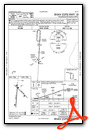
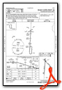
Instrument Approach Procedure (IAP) Charts


Nearby Airports with Instrument Procedures
| ID | Name | Heading / Distance | ||
|---|---|---|---|---|
 |
KFFL | Fairfield Municipal Airport | 226° | 19.1 |
|
KMPZ | Mount Pleasant Municipal Airport | 159° | 21.1 |
|
KIOW | Iowa City Municipal Airport | 014° | 22.6 |
|
KMUT | Muscatine Municipal Airport | 076° | 24.5 |
|
KOTM | Ottumwa Regional Airport | 254° | 36.4 |
|
KCID | The Eastern Iowa Airport | 357° | 36.6 |
|
KOOA | Oskaloosa Municipal Airport | 265° | 37.1 |
|
8C4 | Mathews Memorial Airport | 038° | 37.6 |
|
KBRL | Southeast Iowa Regional Airport | 139° | 38.7 |
|
KFSW | Fort Madison Municipal Airport | 156° | 40.2 |
|
KTZT | Belle Plaine Municipal Airport | 323° | 45.4 |
|
C17 | Marion Airport | 008° | 45.7 |
Airport Images
Do you have a recent image of this airport? Upload it here!


