Login
Register


BQP
Morehouse Memorial Airport
Official FAA Data Effective 2026-01-22 0901Z
Chart Supplement

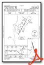
VFR Chart of KBQP
Sectional Charts at SkyVector.com
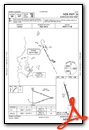
IFR Chart of KBQP
Enroute Charts at SkyVector.com
Location Information for KBQP
Coordinates: N32°45.36' / W91°52.83'Located 02 miles SE of Bastrop, Louisiana on 440 acres of land. View all Airports in Louisiana.
Surveyed Elevation is 167 feet MSL.
Operations Data
|
|
Airport Communications
| AWOS-3PT: | 118.375 Tel. 318-281-1443 |
|---|---|
| MONROE APPROACH: | 126.9 307.9 |
| MONROE DEPARTURE: | 126.9 307.9 |
| UNICOM: | 122.800 |
| CTAF: | 122.800 |
| ATIS at MLU (16.7 SW): | 125.05 |
| ASOS at MLU (16.7 SW): | 318-327-5675 |
| AWOS-3PT at RSN (38.6 W): | 119.525 318-242-0062 |
- APCH/DEP CTL SVC PRVDD BY FORT WORTH ARTCC (ZFW) ON FREQS 126.325/346.25 (MONROE RCAG) WHEN MONROE APCH CTL (MLU) CLSD.
Nearby Navigation Aids
|
| ||||||||||||||||||||||||||||||||||||||||||||||||||||||||||||


Runway 16/34
| Dimensions: | 4002 x 100 feet / 1220 x 30 meters | |
|---|---|---|
| Surface: | Asphalt in Fair Condition | |
| Weight Limits: | S-15 | |
| Edge Lighting: | Medium Intensity | |
| Runway 16 | Runway 34 | |
| Coordinates: | N32°45.68' / W91°52.94' | N32°45.05' / W91°52.72' |
| Elevation: | 158.8 | 162.3 |
| Traffic Pattern: | Left | Left |
| Runway Heading: | 164° True | 344° True |
| Markings: | Non-Precision Instrument in poor condition. | Non-Precision Instrument in poor condition. |
| Glide Slope Indicator | P2L (3.00° Glide Path Angle) PAPI OTS INDEFLY. | P2L (3.00° Glide Path Angle) |
| REIL: | Yes | Yes |
Services Available
| Fuel: | 100LL (blue) |
|---|---|
| Transient Storage: | Tiedowns |
| Airframe Repair: | MINOR |
| Engine Repair: | MINOR |
| Bottled Oxygen: | NONE |
| Bulk Oxygen: | NONE |
Ownership Information
| Ownership: | Publicly owned | |
|---|---|---|
| Owner: | CITY OF BASTROP | |
| PO BOX 431 | ||
| BASTROP, LA 71221 | ||
| 318-283-0250 | ||
| Manager: | BRENT ELTON | |
| 6336 HOLLAND DRIVE | ||
| BASTROP, LA 71220 | ||
| 318-281-2018 | ||
Other Remarks
- DEER ON & INVOF RY.
- FOR CD CTC MONROE APCH AT 318-327-5641, IF UNAVBL, CTC FORT WORTH ARTCC AT 817-858-7584.
- RWY MKGS IN POOR COND DUE TO FADING AND MOLD GROWTH.
- CRACKING, FADING, & MOLD GROWTH ON RWY MKGS.
- 0LL SELF SERVE FUEL AVBL 24 HRS WITH CREDIT CARD.
- DUSK-DAWN. REIL RWYS 16 & 34; MIRL RWY 16/34 PRESET LOW INTST DUSK-DAWN; TO INCR INTST ACTVT - CTAF.
Weather Minimums
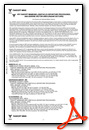
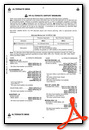
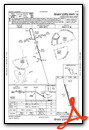
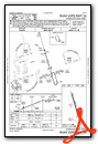
Instrument Approach Procedure (IAP) Charts
Nearby Airports with Instrument Procedures
| ID | Name | Heading / Distance | ||
|---|---|---|---|---|
 |
KMLU | Monroe Regional Airport | 208° | 16.7 |
|
M79 | John H Hooks Jr Memorial Airport | 161° | 17.1 |
|
KCRT | Z M Jack Stell Field Airport | 000° | 25.3 |
|
KRSN | Ruston Regional Airport | 248° | 38.7 |
|
M32 | Lake Village Municipal Airport | 038° | 45.4 |
|
3M9 | Warren Municipal/John B Frazer Jr Field Airport | 347° | 49.3 |
|
KTVR | Vicksburg Tallulah Regional Airport | 119° | 49.6 |
|
KLLQ | Monticello Municipal/Ellis Field Airport | 007° | 53.2 |
|
F88 | Jonesboro Airport | 232° | 54.5 |
|
KELD | South Arkansas Regional At Goodwin Field Airport | 300° | 54.6 |
|
KVKS | Vicksburg Municipal Airport | 122° | 57.4 |
|
7M1 | Mc Gehee Municipal Airport | 026° | 57.9 |
Airport Images
Do you have a recent image of this airport? Upload it here!


