Login
Register


CZD
Cozad Municipal Airport
Official FAA Data Effective 2026-02-19 0901Z
Chart Supplement

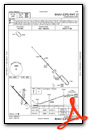
VFR Chart of KCZD
Sectional Charts at SkyVector.com
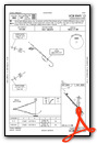
IFR Chart of KCZD
Enroute Charts at SkyVector.com
Location Information for KCZD
Coordinates: N40°52.18' / W100°0.26'Located 01 miles NW of Cozad, Nebraska on 299 acres of land. View all Airports in Nebraska.
Surveyed Elevation is 2503 feet MSL.
Operations Data
|
|
Airport Communications
| UNICOM: | 122.800 |
|---|---|
| CTAF: | 122.800 |
| AWOS-3 at LXN (11.4 SE): | 121.025 308-324-5975 |
| ASOS at LBF (33.7 NW): | 118.425 308-220-0580 |
| AWOS-3PT at CSB (34.5 S): | 118.375 308-697-4279 |
- APCH/DEP CTL SVC PRVDD BY DENVER ARTCC (ZDV) ON FREQS 132.7/226.675 (NORTH PLATTE RCAG).
Nearby Navigation Aids
|
| ||||||||||||||||||||||||||||||||||||||||||||||||


Runway 13/31
| Dimensions: | 5000 x 75 feet / 1524 x 23 meters | |
|---|---|---|
| Surface: | Concrete in Good Condition | |
| Weight Limits: | S-30 | |
| Edge Lighting: | Medium Intensity | |
| Runway 13 | Runway 31 | |
| Coordinates: | N40°52.50' / W100°0.68' | N40°51.89' / W99°59.95' |
| Elevation: | 2503.2 | 2497.3 |
| Traffic Pattern: | Left | Left |
| Runway Heading: | 137° True | 317° True |
| Markings: | Non-Precision Instrument in good condition. | Non-Precision Instrument in good condition. |
| Glide Slope Indicator | P2L (3.00° Glide Path Angle) | P2L (3.75° Glide Path Angle) |
| Obstacles: | GRAIN ELEVATOR. |
167 ft Other 3560 ft from runway, 330 ft right of center CLNC SLP 26:1 ALSO DUE TO ROAD 631 FT OUT 16 FT ABV 0B. |
Runway 18/36
| Dimensions: | 3000 x 300 feet / 914 x 91 meters | |
|---|---|---|
| Surface: | Turf in Good Condition | |
| Runway 18 | Runway 36 | |
| Coordinates: | N40°52.39' / W100°0.10' | N40°51.90' / W100°0.22' |
| Elevation: | 2499.5 | 2497.2 |
| Traffic Pattern: | Left | Left |
| Runway Heading: | 191° True | 11° True |
| Displaced Threshold: | 20 Feet | |
| Obstacles: | 15 ft Road 309 ft from runway, 156 ft right of center | 25 ft Railroad 515 ft from runway, 176 ft left of center |
Services Available
| Fuel: | 100LL (blue), Jet-A |
|---|---|
| Transient Storage: | Hangars,Tiedowns CALL AHD FOR HNGR AVBL 308-784-3868. |
| Airframe Repair: | NONE |
| Engine Repair: | NONE |
| Bottled Oxygen: | NONE |
| Bulk Oxygen: | NONE |
| Other Services: | CROP DUSTING SERVICES,PILOT INSTRUCTION,AIRCRAFT RENTAL,AIRCRAFT SALES |
Ownership Information
| Ownership: | Publicly owned | |
|---|---|---|
| Owner: | COZAD AIRPORT AUTHORITY | |
| PO BOX 2000 | ||
| COZAD, NE 69130-2000 | ||
| 308-784-3868 | ||
| Manager: | ALLISON DONNER | |
| P.O. BOX 458 | ||
| COZAD, NE 69130-0458 | ||
| 308-784-3868 | ||
Other Remarks
- RWY 18/36 NOT PLOWED WINTER MONTHS.
- FOR CD CTC DENVER ARTCC AT 303-651-4257.
- MKD WITH YELLOW CONES.
- MKD WITH YELLOW CONES.
- 0LL AVBL H24 VIA CREDIT CARD.
- AVBL H24 VIA CREDIT CARD.
- ACTVT PAPI RWY 13 & 31; MIRL RWY 13/31 - CTAF.
Weather Minimums

Instrument Approach Procedure (IAP) Charts

Nearby Airports with Instrument Procedures
| ID | Name | Heading / Distance | ||
|---|---|---|---|---|
 |
KGTE | Gothenburg Municipal Airport | 297° | 7.3 |
|
KLXN | Jim Kelly Field Airport | 114° | 11.4 |
|
47V | Curtis Municipal Airport | 237° | 25.5 |
|
KLBF | North Platte Regional/Lee Bird Field Airport | 296° | 34.5 |
|
KCSB | Cambridge Municipal Airport | 192° | 34.5 |
|
KBBW | Broken Bow Municipal/Keith Glaze Field Airport | 025° | 37.7 |
|
KHDE | Brewster Field Airport | 129° | 39.5 |
|
KEAR | Kearney Regional Airport | 100° | 46.2 |
|
KMCK | Mc Cook Ben Nelson Regional Airport | 214° | 48.0 |
|
0F4 | Loup City Municipal Airport | 061° | 52.4 |
|
0V3 | Pioneer Village Field Airport | 113° | 52.8 |
|
4D9 | Alma Municipal Airport | 146° | 54.5 |
Airport Images
 from S")
By: 2flaps


Comments
mid-runway turnaround
Note that this airfield now appears to have a distinctive turnaround south of the runway at about midfield, which does not show on the chart supp diagram.