Login
Register


DTO
Denton Enterprise Airport
Official FAA Data Effective 2026-01-22 0901Z
From the Flight Deck
Chart Supplement

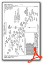
KDTO Airport Diagram

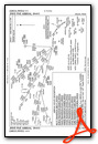
VFR Chart of KDTO
Sectional Charts at SkyVector.com
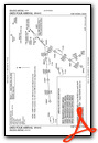
IFR Chart of KDTO
Enroute Charts at SkyVector.com
Location Information for KDTO
Coordinates: N33°12.12' / W97°11.95'Located 03 miles W of Denton, Texas on 929 acres of land. View all Airports in Texas.
Surveyed Elevation is 642 feet MSL.
Operations Data
|
|
Airport Communications
| ATIS: | 119.325 |
|---|---|
| ASOS: | 119.325 Tel. 940-383-8457 |
| DENTON TOWER: | 119.95 |
| DENTON GROUND: | 123.95 |
| LONE STAR APPROACH: | 118.1 306.95 306.95 ;NORTH |
| LONE STAR DEPARTURE: | 118.1 306.95 306.95 ;NORTH |
| CLEARANCE DELIVERY: | 123.95 123.95 |
| TRUUK RNAV STAR: | 124.3 282.275 |
| SASIE STAR: | 124.3 282.275 |
| JFRYE STAR: | 306.95 |
| GARLAND DP: | 118.1 306.95 |
| NANDR RNAV DP: | 118.1 306.95 |
| HERBZ STAR: | 118.1 306.95 |
| DODJE STAR: | 125.2 125.9 343.65 |
| CTAF: | 119.950 |
| JOE POOL DP: | 118.1 306.95 |
| LIKES STAR: | 125.8 ;SOUTH 135.975 ;NORTH 257.95 |
| DALLAS AREA DP: | 118.1 306.95 |
| REEKO STAR: | 125.2 343.65 |
| GREGS STAR: | 118.1 306.95 |
| BOTCH DP: | 118.1 306.95 |
| ASOS at AFW (13.9 SW): | 817-491-6188 |
| ATIS at AFW (14.1 SW): | 126.925 |
| AWOS-3 at LUD (19.4 W): | 118.225 940-627-2365 |
Nearby Navigation Aids
|
| ||||||||||||||||||||||||||||||||||||||||||||||||||||||


Runway 18L/36R
| Dimensions: | 7002 x 150 feet / 2134 x 46 meters | |
|---|---|---|
| Surface: | Asphalt in Fair Condition | |
| Weight Limits: | S-70, D-100 | |
| Edge Lighting: | Medium Intensity | |
| Runway 18L | Runway 36R | |
| Coordinates: | N33°12.70' / W97°11.86' | N33°11.55' / W97°11.89' |
| Elevation: | 639.2 | 626.9 |
| Traffic Pattern: | Left | Left |
| Runway Heading: | 181° True | 1° True |
| Displaced Threshold: | 100 Feet | |
| Declared Distances: | TORA:7002 TODA:7002 ASDA:6502 LDA:6502 | TORA:7002 TODA:7002 ASDA:6602 LDA:6502 |
| Markings: | Precision Instrument in good condition. | Precision Instrument in good condition. |
| Glide Slope Indicator | P4L (3.00° Glide Path Angle) | P4L (3.00° Glide Path Angle) |
| Approach Lights: | MALSR 1,400 Foot Medium-intensity Approach Lighting System with runway alignment indicator lights. | |
| Obstacles: | 20 ft Trees 720 ft from runway, 185 ft right of center 15 FT LOCALIZER ANT, 500 FT DSTC, OBSTN CLNC 20:1, 40:1 TO DTHR. |
20 ft Trees 890 ft from runway, 250 ft left of center OBSTN CLNC 49:1 TO DTHR OVR 20 FT TREES, 980 DSTC, 40:1 OVR LOC ANT, 600 FT DSTC. |
Runway 18R/36L
| Dimensions: | 5003 x 75 feet / 1525 x 23 meters | |
|---|---|---|
| Surface: | Asphalt in Excellent Condition | |
| Weight Limits: | S-30 | |
| Edge Lighting: | Medium Intensity | |
| Runway 18R | Runway 36L | |
| Coordinates: | N33°12.52' / W97°12.03' | N33°11.69' / W97°12.05' |
| Elevation: | 642.6 | 627.2 |
| Runway Heading: | 181° True | 1° True |
| Markings: | Non-Precision Instrument in good condition. | Non-Precision Instrument in good condition. |
| Glide Slope Indicator | P4L (3.00° Glide Path Angle) | P4L (3.00° Glide Path Angle) |
Services Available
| Fuel: | 100LL (blue), Jet-A |
|---|---|
| Transient Storage: | Hangars,Tiedowns |
| Airframe Repair: | MAJOR |
| Engine Repair: | MAJOR |
| Bottled Oxygen: | NONE |
| Bulk Oxygen: | NONE |
| Other Services: | AIR FREIGHT SERVICES,AVIONICS,CHARTER SERVICE,PILOT INSTRUCTION,AIRCRAFT RENTAL,AIRCRAFT SALES |
Ownership Information
| Ownership: | Publicly owned | |
|---|---|---|
| Owner: | CITY OF DENTON | |
| 601 EAST HICKORY STREET | ||
| DENTON, TX 76201 | ||
| 940-349-7736 | ||
| Manager: | RYAN ADAMS | |
| 5000 AIRPORT RD | ||
| DENTON, TX 76207-0207 | ||
| 940-349-7744 | RYAN.ADAMS@CITYOFDENTON.COM | |
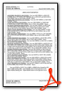
Other Remarks
- RWY 18L DESIGNATED AS A CALM WIND RWY.
- ARPT CLSD TO ULTRALIGHTS AND GLIDERS.
- MOWING OPNS ON ARPT MAY-SEP.
- FOR CD WHEN ATCT IS CLSD CTC REGIONAL APCH AT 972-615-2799.
- DUSK-DAWN WHEN ATCT CLSD, MIRL RWY 18L/36R & 18R/36L PRESET TO LOW INTST; TO INCR INTST & ACTVT MALSR RWY 18L - CTAF.
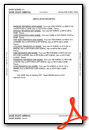
Weather Minimums

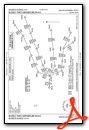
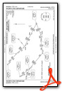
Standard Terminal Arrival (STAR) Charts
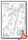
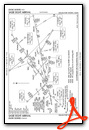
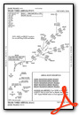
Instrument Approach Procedure (IAP) Charts
Departure Procedure (DP) Charts
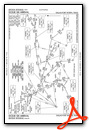
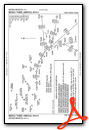
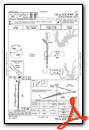
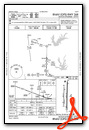
- BOTCH ONE (RNAV)

- BOTCH ONE (RNAV), CONT.1
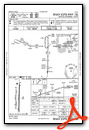
- DALLAS FOUR
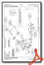
- DALLAS FOUR, CONT.1
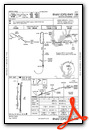
- GARLAND SIX
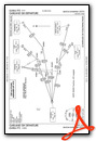
- GARLAND SIX, CONT.1
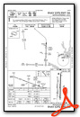
- JOE POOL EIGHT
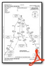
- JOE POOL EIGHT, CONT.1
- KINGDOM FIVE
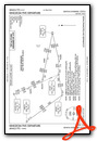
- KINGDOM FIVE, CONT.1
- KUSSO TWO (RNAV)
- KUSSO TWO (RNAV), CONT.1
- NANDR THREE (RNAV)
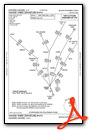
- NANDR THREE (RNAV), CONT.1
- TEXOMA FIVE

- TEXOMA FIVE, CONT.1
- WORTH ONE
- WORTH ONE, CONT.1

Nearby Airports with Instrument Procedures
| ID | Name | Heading / Distance | ||
|---|---|---|---|---|
 |
KAFW | Perot Field/Fort Worth Alliance Airport | 205° | 14.1 |
|
KLUD | Decatur Municipal Airport | 279° | 19.4 |
|
4T2 | Kenneth Copeland Airport | 227° | 20.0 |
|
KDFW | Dallas-Fort Worth International Airport | 155° | 20.0 |
|
KADS | Addison Airport | 127° | 23.0 |
|
KFTW | Fort Worth Meacham International Airport | 199° | 24.3 |
|
KGLE | Gainesville Municipal Airport | 000° | 27.0 |
|
KDAL | Dallas Love Field Airport | 140° | 27.6 |
|
KNFW | Fort Worth NAS Jrb (Carswell Field) Airport | 205° | 28.7 |
|
KTKI | Mckinney Ntl Airport | 092° | 30.8 |
|
KGPM | Grand Prairie Municipal Airport | 165° | 31.1 |
|
KXBP | Bridgeport Municipal Airport | 267° | 31.7 |
Fuel Providers


We proudly offer fuel from:

US Dollar per US Gallon
Price Provided by FBO


