Login
Register


FPK
Fitch H Beach Airport
Official FAA Data Effective 2026-01-22 0901Z
Chart Supplement

VFR Chart of KFPK
Sectional Charts at SkyVector.com
IFR Chart of KFPK
Enroute Charts at SkyVector.com
Location Information for KFPK
Coordinates: N42°34.45' / W84°48.73'Located 01 miles NE of Charlotte, Michigan on 190 acres of land. View all Airports in Michigan.
Surveyed Elevation is 891 feet MSL.
Operations Data
|
|
Airport Communications
| AWOS-3P: | 118.075 Tel. 517-543-2288 |
|---|---|
| GREAT LAKES APPROACH: | 118.65 226.4 |
| GREAT LAKES DEPARTURE: | 118.65 226.4 |
| CTAF: | 123.000 |
| UNICOM: | 123.000 |
| ASOS at LAN (15.3 NE): | 517-908-8494 |
| ATIS at LAN (15.8 NE): | 119.75 |
| AWOS-3P at TEW (17.2 E): | 119.425 517-676-5607 |
- APCH/DEP SVC PRVDD BY CLEVELAND ARTCC (ZOB) ON FREQS 120.45/360.7 (LITCHFIELD RCAG) WHEN GREAT LAKES APCH CTL CLSD.
Nearby Navigation Aids
|
| ||||||||||||||||||||||||||||||||||||||||||||||||||||||||||||


Runway 03/21
| Dimensions: | 3510 x 75 feet / 1070 x 23 meters | |
|---|---|---|
| Surface: | Concrete in Good Condition | |
| Weight Limits: | S-26 | |
| Edge Lighting: | Medium Intensity | |
| Runway 03 | Runway 21 | |
| Coordinates: | N42°34.20' / W84°48.82' | N42°34.74' / W84°48.55' |
| Elevation: | 879.7 | 891.0 |
| Traffic Pattern: | Left | Left |
| Runway Heading: | 21° True | 201° True |
| Markings: | Non-Precision Instrument in good condition. | Non-Precision Instrument in good condition. |
| Glide Slope Indicator | P4L (4.00° Glide Path Angle) | P4L (4.00° Glide Path Angle) |
| REIL: | Yes | Yes |
| Obstacles: | 8 ft Brush 345 ft from runway, 259 ft left of center | 41 ft Tree 827 ft from runway, 300 ft left of center |
Runway 15/33
CLSD DEC-MAR & WHEN SNOW COVD. | ||
| Dimensions: | 2298 x 95 feet / 700 x 29 meters | |
|---|---|---|
| Surface: | Turf in Good Condition | |
| Runway 15 | Runway 33 | |
| Coordinates: | N42°34.56' / W84°48.93' | N42°34.25' / W84°48.64' |
| Elevation: | 879.5 | 880.3 |
| Traffic Pattern: | Left | Left |
| Runway Heading: | 145° True | 325° True |
| Displaced Threshold: | 760 Feet | 193 Feet |
| Obstacles: | 18 ft Tree 145 ft from runway, 78 ft left of center APCH RATIO 19:1 TO DTHR OVR +94 FT TREE, 1785 FT DIST, 50 FT L. |
3 ft Ground 0 ft from runway, 70 ft right of center CTLG OBSTN EXCEEDS A 45 DEG SLP. APCH RATIO 20:1 TO DTHR. |
Services Available
| Fuel: | 100LL (blue) |
|---|---|
| Transient Storage: | Hangars,Tiedowns |
| Airframe Repair: | MAJOR |
| Engine Repair: | MAJOR |
| Bottled Oxygen: | NONE |
| Bulk Oxygen: | NONE |
Ownership Information
| Ownership: | Publicly owned | |
|---|---|---|
| Owner: | CITY OF CHARLOTTE/CITY MANAGER | |
| 111 E LAWRENCE AVE | ||
| CHARLOTTE, MI 48813-1573 | ||
| 517-543-2750 | ||
| Manager: | TODD COTTER | |
| 1325 ISLAND HWY | ||
| CHARLOTTE, MI 48813-9358 | ||
| 517-712-8177 | ||
Other Remarks
- MIL HOP ON & INVOF ARPT SPCLY AT NGT.
- DEER & LRG BIRDS ON & INVOF ARPT.
- GND MOLES & WATERFOWL ON RWY 15/33.
- FOR CD CTC GREAT LAKES APCH AT 269-459-3345, WHEN APCH CLSD CTC CLEVELAND ARTCC AT 440-774-0224/0490.
- ACFT WO RADIO OPRG INVOF ARPT.
- RWY & DTHR MKD WITH 3 FT YELLOW CONES.
- RWY & DTHR MKD WITH 3 FT YELLOW CONES.
- ACTVT REIL RWY 03/21; PAPI RWY 03 & 21; MIRL RWY 03/21 - CTAF.
Weather Minimums

Instrument Approach Procedure (IAP) Charts
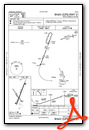
Nearby Airports with Instrument Procedures
| ID | Name | Heading / Distance | ||
|---|---|---|---|---|
 |
4D0 | Abrams Municipal Airport | 016° | 12.5 |
|
KLAN | Capital Region International Airport | 039° | 15.8 |
|
KTEW | Mason Jewett Field Airport | 091° | 17.2 |
|
KRMY | Brooks Field Airport | 198° | 20.4 |
|
9D9 | Hastings Airport | 282° | 24.2 |
|
KJXN | Jackson County/Reynolds Field Airport | 140° | 24.4 |
|
Y70 | Ionia County Airport | 333° | 24.4 |
|
KBTL | Battle Creek Exec At Kellogg Field Airport | 230° | 25.2 |
|
KGRR | Gerald R Ford International Airport | 300° | 36.4 |
|
KOZW | Livingston County/Spencer J Hardy Airport | 084° | 36.9 |
|
KAZO | Kalamazoo/Battle Creek International Airport | 238° | 38.7 |
|
KRNP | Owosso Community Airport | 049° | 38.9 |
Airport Images
Do you have a recent image of this airport? Upload it here!


