Login
Register


GLY
Clinton Regional Airport
Official FAA Data Effective 2026-02-19 0901Z
Chart Supplement

VFR Chart of KGLY
Sectional Charts at SkyVector.com
IFR Chart of KGLY
Enroute Charts at SkyVector.com
Location Information for KGLY
Coordinates: N38°21.28' / W93°40.75'Located 04 miles E of Clinton, Missouri on 378 acres of land. View all Airports in Missouri.
Surveyed Elevation is 822 feet MSL.
Operations Data
|
|
Airport Communications
| AWOS-3PT: | 120.475 Tel. 660-885-3851 |
|---|---|
| WHITEMAN APPROACH: | 127.45 |
| WHITEMAN DEPARTURE: | 125.925 |
| CTAF: | 122.800 |
| UNICOM: | 122.800 |
| AWOS-3PT at RAW (15.7 E): | 118.325 660-547-3761 |
| ATIS at SZL (23.4 N): | 239.025 |
| AWOS-3PT at RCM (26.5 N): | 119.575 660-422-7010 |
- APCH/DEP SVC PRVDD BY KANSAS CITY ARTCC ON FREQS 135.575/323.15 (KNOB NOSTER RCAG) WHEN WHITEMAN APCH CTL CLSD.
Nearby Navigation Aids
|
| ||||||||||||||||||||||||||||||||||||||||||||||||||||||


Runway 18/36
| Dimensions: | 5000 x 75 feet / 1524 x 23 meters | |
|---|---|---|
| Surface: | Concrete in Excellent Condition | |
| Weight Limits: | S-60, ST-72 | |
| Edge Lighting: | Medium Intensity | |
| Runway 18 | Runway 36 | |
| Coordinates: | N38°21.60' / W93°40.50' | N38°20.78' / W93°40.53' |
| Elevation: | 810.1 | 803.5 |
| Runway Heading: | 182° True | 2° True |
| Markings: | Non-Precision Instrument | Non-Precision Instrument |
| Glide Slope Indicator | P4L (3.00° Glide Path Angle) | P4L (3.00° Glide Path Angle) |
| REIL: | Yes | Yes |
Runway 04/22
| Dimensions: | 4001 x 60 feet / 1220 x 18 meters | |
|---|---|---|
| Surface: | Asphalt in Fair Condition | |
| Weight Limits: | S-12, D-16 | |
| Edge Lighting: | Medium Intensity | |
| Runway 04 | Runway 22 | |
| Coordinates: | N38°21.16' / W93°41.35' | N38°21.63' / W93°40.75' |
| Elevation: | 819.2 | 822.4 |
| Traffic Pattern: | Left | Left |
| Runway Heading: | 45° True | 225° True |
| Markings: | Non-Precision Instrument in good condition. | Non-Precision Instrument in good condition. |
| Glide Slope Indicator | P4L (3.50° Glide Path Angle) | P4L (3.50° Glide Path Angle) |
| REIL: | Yes | Yes |
| Obstacles: | 67 ft Trees 1298 ft from runway, 350 ft right of center | |
Services Available
| Fuel: | 100LL (blue), Jet-A |
|---|---|
| Transient Storage: | Tiedowns |
| Airframe Repair: | MAJOR |
| Engine Repair: | MAJOR |
| Bottled Oxygen: | NOT AVAILABLE |
| Bulk Oxygen: | NONE |
| Other Services: | PILOT INSTRUCTION,AIRCRAFT RENTAL |
Ownership Information
| Ownership: | Publicly owned | |
|---|---|---|
| Owner: | CITY OF CLINTON | |
| 105 E. OHIO | ||
| CLINTON, MO 64735 | ||
| 660-885-6121 | ||
| Manager: | CLINTON AIRPORT ASSOCIATION, INC. | |
| 20 SE AIRPORT ROAD | ||
| CLINTON, MO 64735 | ||
| (660) 885-8889 | ||
Other Remarks
- FOR CD IF UNA TO CTC ON FSS FREQ, CTC WHITEMAN APCH AT 660-687-3132. WHEN WHITEMAN APCH IS CLSD, CTC KANSAS CITY ARTCC AT 913-254-8508.
- 0LL FUEL AVBL 24 HRS. SINGLE POINT JET A AVBL. AFTER HRS CALL ARPT MANAGER, 660-885-8889
- MIRL RWY 04/22 AND RWY 18/36 OPER DUSK-2200. AFTER 2200 ACTVT MIRL RWY 04/22 AND RWY 18/36 - CTAF. ACTVT REIL RWYS 04, 18, 22 & 36; PAPI RWYS 04, 18, 22 & 36 - CTAF.
Weather Minimums


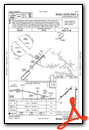
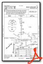
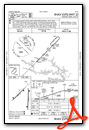
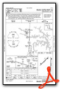
Instrument Approach Procedure (IAP) Charts
Nearby Airports with Instrument Procedures
| ID | Name | Heading / Distance | ||
|---|---|---|---|---|
 |
KRAW | Warsaw Municipal Airport | 091° | 15.8 |
|
KSZL | Whiteman AFB Airport | 015° | 23.3 |
|
KRCM | Skyhaven Airport | 347° | 26.4 |
|
KBUM | Butler Memorial Airport | 263° | 31.4 |
|
KDMO | Sedalia Regional Airport | 048° | 31.8 |
|
KLRY | Lawrence Smith Memorial Airport | 296° | 34.8 |
|
MO3 | Stockton Lake Airport | 188° | 42.1 |
|
KNVD | Nevada Municipal Airport | 224° | 42.2 |
|
KHIG | Higginsville Industrial Municipal Airport | 000° | 43.0 |
|
3GV | East Kansas City Airport | 327° | 46.9 |
|
M17 | Bolivar Municipal Airport | 160° | 48.1 |
|
KLXT | Kansas City/Lee's Summit Regional Airport | 318° | 48.7 |
Airport Images
Do you have a recent image of this airport? Upload it here!


