Login
Register


JDD
Wood County/Collins Field Airport
Official FAA Data Effective 2025-11-27 0901Z
Chart Supplement

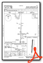
VFR Chart of KJDD
Sectional Charts at SkyVector.com
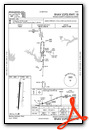
IFR Chart of KJDD
Enroute Charts at SkyVector.com
Location Information for KJDD
Coordinates: N32°44.53' / W95°29.79'Located 05 miles N of Mineola/Quitman, Texas on 106 acres of land. View all Airports in Texas.
Surveyed Elevation is 432 feet MSL.
Operations Data
|
|
Airport Communications
| AWOS-3: | 118.9 Tel. 903-768-3065 |
|---|---|
| LONGVIEW APPROACH: | 128.75 379.15 |
| LONGVIEW DEPARTURE: | 128.75 379.15 |
| CTAF: | 122.800 |
| UNICOM: | 122.800 |
| ASOS at TYR (23.5 S): | 903-535-9105 |
| ATIS at TYR (23.8 S): | 126.25 |
| AWOS-3 at SLR (25.8 N): | 118.35 903-885-9605 |
- APCH/DEP SVC PRVDD BY FORT WORTH ARTCC (ZFW) ON FREQS 132.025/317.75 (CUMBY RCAG) WHEN LONGVIEW APCH CTL CLSD.
Nearby Navigation Aids
|
| ||||||||||||||||||||||||||||||||||||||||||||||||||||||||||||


Runway 18/36
| Dimensions: | 4002 x 60 feet / 1220 x 18 meters | |
|---|---|---|
| Surface: | Asphalt in Fair Condition | |
| Weight Limits: | S-12 | |
| Edge Lighting: | Medium Intensity | |
| Runway 18 | Runway 36 | |
| Coordinates: | N32°44.86' / W95°29.77' | N32°44.20' / W95°29.80' |
| Elevation: | 402.5 | 432.6 |
| Runway Heading: | 182° True | 2° True |
| Markings: | Non-Precision Instrument in fair condition. | Non-Precision Instrument in fair condition. |
| Glide Slope Indicator | P2L (3.00° Glide Path Angle) | P2L (3.00° Glide Path Angle) PAPI UNUSBL 6 DEGS LEFT OF CNTRLN. |
| Obstacles: | 90 ft Trees 2000 ft from runway | 70 ft Trees 201 ft from runway, 234 ft right of center 70 FT TREES 45-200 FT DSTC, 234 FT R. |
Services Available
| Fuel: | 100LL (blue), Jet-A |
|---|---|
| Transient Storage: | Hangars,Tiedowns |
| Airframe Repair: | MAJOR |
| Engine Repair: | MAJOR |
| Bottled Oxygen: | NOT AVAILABLE |
| Bulk Oxygen: | NOT AVAILABLE |
| Other Services: | PILOT INSTRUCTION |
Ownership Information
| Ownership: | Publicly owned | |
|---|---|---|
| Owner: | WOOD COUNTY | |
| WOOD COUNTY COURTHOUSE, 100 S. MAIN STREET | ||
| QUITMAN, TX 75783 | ||
| 903-768-2100 | ||
| Manager: | JOHN WISDOM | |
| 317 COUNTY RD 2355 | ||
| MINEOLA, TX 75773-3715 | ||
| 903-768-2100 | ||
Other Remarks
- BLUE TWY CNTRLN REFLECTORS.
- WILDLIFE INVOF ARPT.
- FOR CD CTC FORT WORTH ARTCC AT 817-858-7584.
- (CONTACT PHONE NR) ERIN@WOODCOUNTYAIRPORT.NET
- 04 NM SW OF QUITMAN.
- 0LL SELF SERVE FUEL.
- MIRL RWY 18/36 PRESET LOW INTST DUSK-DAWN; TO INCR INTST ACTVT - CTAF. PAPI RWYS 18 & 36 OPR CONSLY.
Weather Minimums

Instrument Approach Procedure (IAP) Charts
Nearby Airports with Instrument Procedures
| ID | Name | Heading / Distance | ||
|---|---|---|---|---|
 |
F51 | Winnsboro Municipal Airport | 042° | 16.1 |
|
KTYR | Tyler Pounds Regional Airport | 168° | 23.8 |
|
KSLR | Sulphur Springs Municipal Airport | 345° | 25.8 |
|
KJXI | Fox Stephens Field/Gilmer Municipal Airport | 095° | 27.8 |
|
07F | Gladewater Municipal Airport | 115° | 29.5 |
|
F53 | Franklin County Airport | 024° | 31.2 |
|
KOSA | Mount Pleasant Regional Airport | 051° | 34.4 |
|
KGVT | Majors Airport | 304° | 34.7 |
|
F44 | Athens Municipal Airport | 206° | 38.5 |
|
2F7 | Commerce Municipal Airport | 328° | 38.7 |
|
KTRL | Terrell Municipal Airport | 267° | 39.1 |
|
7F3 | Caddo Mills Municipal Airport | 295° | 41.6 |
Airport Images
Do you have a recent image of this airport? Upload it here!


