Login
Register


LYO
Lyons-Rice County Municipal Airport
Official FAA Data Effective 2026-01-22 0901Z
Chart Supplement

VFR Chart of KLYO
Sectional Charts at SkyVector.com
IFR Chart of KLYO
Enroute Charts at SkyVector.com
Location Information for KLYO
Coordinates: N38°20.41' / W98°13.71'Located 01 miles W of Lyons, Kansas on 110 acres of land. View all Airports in Kansas.
Surveyed Elevation is 1691 feet MSL.
Operations Data
|
|
Airport Communications
| AWOS-3P: | 119.925 Tel. 620-509-2357 |
|---|---|
| UNICOM: | 122.800 |
| CTAF: | 122.800 |
| ATIS at HUT (23.9 SE): | 124.25 |
| ASOS at HUT (23.9 SE): | 620-662-1071 |
| AWOS-3PT at 9K7 (24.6 N): | 119.675 785-472-9746 |
- APCH/DEP CTL SVC PRVDD BY KANSAS CITY ARTCC (ZKC) ON FREQS 118.8/322.425 (HUTCHINSON RCAG).
Nearby Navigation Aids
|
| ||||||||||||||||||||||||||||||||||||||||||||||||||||||||||||


Runway 17/35
| Dimensions: | 4400 x 75 feet / 1341 x 23 meters | |
|---|---|---|
| Surface: | Concrete in Excellent Condition | |
| Weight Limits: | 12 /R/C/W/T, S-30 | |
| Edge Lighting: | Medium Intensity | |
| Runway 17 | Runway 35 | |
| Coordinates: | N38°20.78' / W98°13.72' | N38°20.05' / W98°13.71' |
| Elevation: | 1691.6 | 1676.0 |
| Traffic Pattern: | Right | Left |
| Runway Heading: | 180° True | 360° True |
| Markings: | Non-Precision Instrument in good condition. | Non-Precision Instrument in good condition. |
| Glide Slope Indicator | P2L (3.00° Glide Path Angle) | P2L (3.00° Glide Path Angle) |
| REIL: | Yes | Yes |
| Obstacles: | 15 ft Road 520 ft from runway | 15 ft Road 335 ft from runway |
Services Available
| Fuel: | 100LL (blue), Jet-A |
|---|---|
| Transient Storage: | Hangars,Tiedowns |
| Airframe Repair: | MAJOR |
| Engine Repair: | MAJOR |
| Bottled Oxygen: | NONE |
| Bulk Oxygen: | NONE |
| Other Services: | CROP DUSTING SERVICES |
Ownership Information
| Ownership: | Publicly owned | |
|---|---|---|
| Owner: | CITY OF LYONS AND RICE CO | |
| 1558 WEST MAIN | ||
| LYONS, KS 67554 | ||
| 620-257-5002 | ||
| Manager: | THOMAS ROBL | |
| 718 WEST 5TH | ||
| LYONS, KS 67554 | ||
| 620-257-2231 | MANAGERS CELL PHONE 785-577-1918 | |
Other Remarks
- FOR CD CTC KANSAS CITY ARTCC AT 913-254-8508.
- COURTESY CAR AVBL.
- 0LL FUEL AVAILABLE DURING NORMAL ATTENDANCE SCHEDULE AFTER HOURS NUMBER 785-577-1918
- JET A ON REQUEST
- ACTVT REIL RWY 17 & 35; PAPI RWY 17 & 35; MIRL RWY 17/35 - CTAF.
Weather Minimums

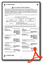
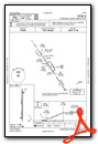
Instrument Approach Procedure (IAP) Charts
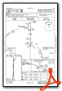
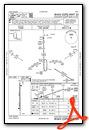
Nearby Airports with Instrument Procedures
| ID | Name | Heading / Distance | ||
|---|---|---|---|---|
 |
KHUT | Hutchinson Regional Airport | 133° | 23.9 |
|
9K7 | Ellsworth Municipal Airport | 359° | 24.6 |
|
KMPR | Mc Pherson Airport | 088° | 25.4 |
|
KGBD | Great Bend Municipal Airport | 270° | 29.8 |
|
47K | Moundridge Municipal Airport | 102° | 35.2 |
|
KSLN | Salina Regional Airport | 044° | 38.3 |
|
9K8 | Kingman/Clyde Cessna Field Airport | 172° | 40.5 |
|
KLQR | Larned-Pawnee County Airport | 259° | 41.3 |
|
KRSL | Russell Municipal Airport | 319° | 42.0 |
|
KPTT | Pratt Regional Airport | 212° | 45.4 |
|
KEWK | Newton-City-County Airport | 110° | 48.2 |
|
KICT | Wichita Dwight D Eisenhower Ntl Airport | 137° | 56.0 |
Airport Images
Do you have a recent image of this airport? Upload it here!


