Login
Register


NRN
Norton Municipal Airport
Official FAA Data Effective 2025-12-25 0901Z
Chart Supplement

VFR Chart of KNRN
Sectional Charts at SkyVector.com
IFR Chart of KNRN
Enroute Charts at SkyVector.com
Location Information for KNRN
Coordinates: N39°51.03' / W99°53.68'Located 01 miles N of Norton, Kansas on 184 acres of land. View all Airports in Kansas.
Surveyed Elevation is 2384 feet MSL.
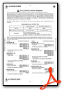
Operations Data
|
|
Airport Communications
| AWOS-3PT: | 118.275 Tel. 785-871-4009 |
|---|---|
| CTAF: | 122.900 |
| AWOS-3PT at PHG (27.5 E): | 119.125 785-543-8960 |
| ASOS at HLC (28.8 S): | 118.425 785-421-3471 |
| AWOS-3PT at OIN (29.9 W): | 119.225 785-470-4236 |
- APCH/DEP CTL SVC PRVDD BY DENVER ARTCC (ZDV) ON FREQS 132.7/226.675 (HILL CITY RCAG).
Nearby Navigation Aids
|
| ||||||||||||||||||||||||||||||||||||||||||


Runway 16/34
| Dimensions: | 4701 x 60 feet / 1433 x 18 meters | |
|---|---|---|
| Surface: | Concrete in Poor Condition RWY SFC ROUGH DUE TO UNEVEN PAVING JOINTS EVERY 10 FT. | |
| Edge Lighting: | High Intensity | |
| Runway 16 | Runway 34 | |
| Coordinates: | N39°51.53' / W99°53.83' | N39°50.78' / W99°53.56' |
| Elevation: | 2384.0 | 2361.9 |
| Runway Heading: | 165° True | 345° True |
| Markings: | Non-Precision Instrument in good condition. | Non-Precision Instrument in good condition. |
| Glide Slope Indicator | P2L (3.00° Glide Path Angle) | P2L (3.00° Glide Path Angle) |
| REIL: | Yes | Yes |
Runway 08/26
| Dimensions: | 2117 x 125 feet / 645 x 38 meters | |
|---|---|---|
| Surface: | Turf in Fair Condition SURFACE ROUGH. | |
| Runway 08 | Runway 26 | |
| Coordinates: | N39°50.75' / W99°53.87' | N39°50.74' / W99°53.42' |
| Elevation: | 2348.6 | 2352.0 |
| Traffic Pattern: | Left | Left |
| Runway Heading: | 92° True | 272° True |
| Obstacles: | 24 ft Trees 510 ft from runway, 85 ft right of center | |
Services Available
| Fuel: | 100LL (blue), Jet-A, Jet A-1+ |
|---|---|
| Transient Storage: | Tiedowns |
| Airframe Repair: | NONE |
| Engine Repair: | NONE |
| Bottled Oxygen: | NOT AVAILABLE |
| Bulk Oxygen: | NOT AVAILABLE |
| Other Services: | CROP DUSTING SERVICES |
Ownership Information
| Ownership: | Publicly owned | |
|---|---|---|
| Owner: | CITY & COUNTY OF NORTON | |
| 301 EAST WASHINGTON, P O BOX 272 | ||
| NORTON, KS 67654 | ||
| 785-877-5000 | ||
| Manager: | BRICE RILEY | |
| 1226 N STATE ST, PO BOX 272 | ||
| NORTON, KS 67654 | ||
| 785-877-2201 | ||
Other Remarks
- FOR CD CTC DENVER ARTCC AT 303-651-4257.
- NO LINE OF SIGHT BETWEEN RWY ENDS.
- FUEL 24 HR SELF-SERVE.
Weather Minimums
Instrument Approach Procedure (IAP) Charts
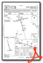
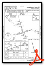
Nearby Airports with Instrument Procedures
| ID | Name | Heading / Distance | ||
|---|---|---|---|---|
 |
KPHG | Phillipsburg Municipal Airport | 104° | 27.6 |
|
KHLC | Hill City Municipal Airport | 174° | 28.3 |
|
4D9 | Alma Municipal Airport | 057° | 29.8 |
|
KOIN | Oberlin Municipal Airport | 268° | 29.8 |
|
KCSB | Cambridge Municipal Airport | 335° | 30.0 |
|
KMCK | Mc Cook Ben Nelson Regional Airport | 303° | 38.6 |
|
KRCP | Rooks County Regional Airport | 137° | 40.8 |
|
KHDE | Brewster Field Airport | 035° | 44.3 |
|
0H1 | Trego Wakeeney Airport | 179° | 50.6 |
|
K82 | Smith Center Municipal Airport | 095° | 51.1 |
|
1QK | Gove County Airport | 198° | 51.2 |
|
KADT | Atwood-Rawlins County City-County Airport | 269° | 53.0 |
Airport Images
Do you have a recent image of this airport? Upload it here!


