Login
Register


OLS
Nogales International Airport
Official FAA Data Effective 2026-01-22 0901Z
Chart Supplement

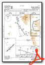
VFR Chart of KOLS
Sectional Charts at SkyVector.com
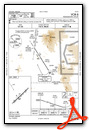
IFR Chart of KOLS
Enroute Charts at SkyVector.com
Location Information for KOLS
Coordinates: N31°25.06' / W110°50.87'Located 07 miles NE of Nogales, Arizona on 340 acres of land. View all Airports in Arizona.
Surveyed Elevation is 3955 feet MSL.
Operations Data
|
|
Airport Communications
| ASOS: | 121.125 Tel. 520-287-9332 |
|---|---|
| TUCSON APPROACH: | 118.75 269.55 |
| TUCSON DEPARTURE: | 118.75 269.55 |
| UNICOM: | 122.800 |
| CTAF: | 122.800 |
| ATIS at FHU (27.7 E): | 134.75 |
| ASOS at FHU (27.7 E): | |
| ATIS at TUS (42.3 N): | 123.8 |
Nearby Navigation Aids
|
| ||||||||||||||||||||||||||||||||||||||||||||||||


Runway 04/22
RWY 22 CALM WIND RWY. SI NOT RCMDD. | ||
| Dimensions: | 7200 x 100 feet / 2195 x 30 meters | |
|---|---|---|
| Surface: | Asphalt in Good Condition | |
| Weight Limits: | S-21
CNTR 90 FT S-21; RMNG WIDTH S-7.
| |
| Edge Lighting: | Medium Intensity | |
| Runway 04 | Runway 22 | |
| Coordinates: | N31°24.65' / W110°51.37' | N31°25.47' / W110°50.37' |
| Elevation: | 3838.9 | 3955.1 |
| Traffic Pattern: | Left | Left |
| Runway Heading: | 46° True | 226° True |
| Displaced Threshold: | 899 Feet | |
| Markings: | Non-Precision Instrument in good condition. | Non-Precision Instrument in good condition. |
| Glide Slope Indicator | P4L (3.00° Glide Path Angle) | P4L (4.00° Glide Path Angle) PAPI UNUSBL BYD 5 DEGS LEFT OF CNTRLN. PAPI DOES NOT PRVD OBSTN CLNC BYD 5.0 NM FM THR. |
| REIL: | Yes | Yes |
Helipad H1
| Dimensions: | 97 x 97 feet / 30 x 30 meters | |
|---|---|---|
| Surface: | Concrete in Good Condition | |
| Weight Limits: | S-22 | |
| Coordinates: | N31°25.18' / W110°50.93' | N0°0.00' / E0°0.00' |
| Elevation: | 3905.0 | |
Services Available
| Fuel: | 100LL (blue), Jet-A |
|---|---|
| Transient Storage: | Hangars,Tiedowns |
| Airframe Repair: | MAJOR |
| Engine Repair: | MAJOR |
| Bottled Oxygen: | NOT AVAILABLE |
| Bulk Oxygen: | NOT AVAILABLE |
| Other Services: | CHARTER SERVICE,PILOT INSTRUCTION,AIRCRAFT RENTAL,AIRCRAFT SALES |
Ownership Information
| Ownership: | Publicly owned | |
|---|---|---|
| Owner: | SANTA CRUZ COUNTY | |
| COUNTY COURTHOUSE | ||
| NOGALES, AZ 85621 | ||
| 520-375-7930 | ||
| Manager: | SETH MILLER | |
| COPPER MOUNTAIN AIR LLC, NOGALES INTERNATIONAL AIRPORT | ||
| NOGALES, AZ 25621 | ||
| 520-287-9120 | ||
Other Remarks
- CLOSE FP - PRESCOTT RADIO 122.4.
- WILDLIFE ON OR INVOF ARPT.
- FOR CD CTC TUCSON APCH AT 520-829-6121.
- TGL NA.
- ACTVT MIRL RWY 04/22 - CTAF.
Weather Minimums

Instrument Approach Procedure (IAP) Charts
Departure Procedure Obstacles (DPO) Charts

Nearby Airports with Instrument Procedures
| ID | Name | Heading / Distance | ||
|---|---|---|---|---|
 |
KFHU | Sierra Vista Municipal-Libby AAF Airport | 068° | 27.8 |
|
KTUS | Tucson International Airport | 353° | 42.1 |
|
KDMA | Davis Monthan AFB Airport | 357° | 44.9 |
|
KRYN | Ryan Field Airport | 339° | 46.5 |
|
KAVQ | Marana Regional Airport | 342° | 62.3 |
|
KDUG | Bisbee Douglas International Airport | 086° | 63.9 |
|
P33 | Cochise County Airport | 044° | 69.5 |
|
P08 | Coolidge Municipal Airport | 342° | 95.6 |
|
KCGZ | Casa Grande Municipal Airport | 333° | 103.2 |
|
KSAD | Safford Regional/1lt Duane Spalsbury Field Airport | 035° | 105.9 |
|
P13 | San Carlos Apache Airport | 004° | 116.3 |
|
KIWA | Mesa Gateway Airport | 340° | 120.4 |
Airport Images
Do you have a recent image of this airport? Upload it here!


