Login
Register


PIB
Hattiesburg/Laurel Regional Airport
Official FAA Data Effective 2026-01-22 0901Z
Chart Supplement

VFR Chart of KPIB
Sectional Charts at SkyVector.com
IFR Chart of KPIB
Enroute Charts at SkyVector.com
Location Information for KPIB
Coordinates: N31°28.03' / W89°20.22'Located 09 miles N of Hattiesburg-Laurel, Mississippi on 1170 acres of land. View all Airports in Mississippi.
Surveyed Elevation is 297 feet MSL.
Operations Data
|
|
Airport Communications
| AWOS-3PT: | 128.325 Tel. 601-584-6701 |
|---|---|
| CTAF: | 123.000 |
| UNICOM: | 123.000 |
| ASOS at HBG (12.9 S): | 135.425 601-544-2185 |
| AWOS-3PT at LUL (14.9 NE): | 119.275 601-425-9792 |
| AWOS-3PT at 0R0 (26.6 W): | 120.675 601-736-4983 |
- APCH/DEP SVC PRVDD BY HOUSTON ARTCC (ZHU) ON FREQS 126.8/327.8 (HATTIESBURG RCAG).
Nearby Navigation Aids
|
| ||||||||||||||||||||||||||||||||||||||||||||||||||||||||||||


Runway 18/36
| Dimensions: | 6503 x 150 feet / 1982 x 46 meters | |
|---|---|---|
| Surface: | Asphalt / Grooved in Good Condition | |
| Weight Limits: | S-125, D-225, ST-275
PCR VALUE: 860/F/C/X/T
| |
| Edge Lighting: | High Intensity | |
| Runway 18 | Runway 36 | |
| Coordinates: | N31°28.57' / W89°20.22' | N31°27.49' / W89°20.22' |
| Elevation: | 297.4 | 293.6 |
| Traffic Pattern: | Left | Left |
| Runway Heading: | 180° True | 360° True |
| Declared Distances: | TORA:6503 TODA:6503 ASDA:6503 LDA:6503 | TORA:6503 TODA:6503 ASDA:6503 LDA:6503 |
| Markings: | Precision Instrument in good condition. | Precision Instrument in good condition. |
| Glide Slope Indicator | P4L (3.00° Glide Path Angle) | P4L (3.00° Glide Path Angle) |
| Approach Lights: | MALSR 1,400 Foot Medium-intensity Approach Lighting System with runway alignment indicator lights. | |
| REIL: | Yes | Yes |
Services Available
| Fuel: | 100 (green), Jet-A |
|---|---|
| Transient Storage: | Hangars,Tiedowns |
| Airframe Repair: | MINOR |
| Engine Repair: | MINOR |
| Bottled Oxygen: | NONE |
| Bulk Oxygen: | NONE |
| Other Services: | PILOT INSTRUCTION,AIRCRAFT RENTAL |
Ownership Information
| Ownership: | Publicly owned | |
|---|---|---|
| Owner: | REGIONAL AIRPORT AUTH | HATTIESBURG-LAUREL REGIONAL AIRPORT AUTHORITY. |
| 1002 TERMINAL DR | ||
| MOSELLE, MS 39459 | ||
| 601-545-3111 | ||
| Manager: | THOMAS HEANUE | |
| 1002 TERMINAL DR | ||
| MOSELLE, MS 39459 | ||
| 601-545-3111 | ||
Other Remarks
- FOR CD CTC HOUSTON ARTCC AT 281-230-5622.
- ACTVT MALSR RWY 18; REILS RWY 18 & 36; HIRL RWY 18/36 - CTAF. HIRL RWY 18/36 PRESET TO MED INTST, TO INCRS INTST - CTAF. PAPIS RWY 18 & 36 OPR CONSLY.
Weather Minimums
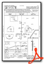
Instrument Approach Procedure (IAP) Charts
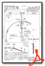
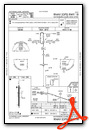
Nearby Airports with Instrument Procedures
| ID | Name | Heading / Distance | ||
|---|---|---|---|---|
 |
KHBG | Hattiesburg Bobby L Chain Municipal Airport | 160° | 12.9 |
|
KLUL | Hesler/Noble Field Airport | 034° | 14.9 |
|
0R0 | Columbia/Marion County Airport | 247° | 26.4 |
|
M43 | Prentiss-Jefferson Davis County Airport | 284° | 30.2 |
|
17M | Magee Municipal Airport | 315° | 33.5 |
|
M24 | Dean Griffin Memorial Airport | 166° | 38.4 |
|
M13 | Poplarville/Pearl River County Airport | 191° | 41.6 |
|
KBXA | George R Carr Memorial Air Field Airport | 214° | 47.6 |
|
1R7 | Brookhaven-Lincoln County Airport | 278° | 55.6 |
|
5R1 | Roy Wilcox Airport | 090° | 58.6 |
|
M11 | Copiah County Airport | 296° | 58.8 |
|
KMEI | Key Field Airport | 029° | 59.8 |
Airport Images
Do you have a recent image of this airport? Upload it here!


Comments
Fuel available.