Login
Register
L61
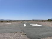
Shoshone Airport
Official FAA Data Effective 2026-01-22 0901Z
VFR Chart of L61
Sectional Charts at SkyVector.com
IFR Chart of L61
Enroute Charts at SkyVector.com
Location Information for L61
Coordinates: N35°58.12' / W116°16.16'Located 01 miles S of Shoshone, California on 20 acres of land. View all Airports in California.
Surveyed Elevation is 1568 feet MSL.
Operations Data
|
|
Airport Communications
| CTAF: | 122.900 |
|---|---|
| ATIS at INS (46.9 NE): | 290.45 |
| ASOS at 1AF (47.8 SW): | |
| ASOS at LAS (54.1 E): | 702-582-5334 |
Nearby Navigation Aids
|
| ||||||||||||||||||||||||||||||||||||
Runway 15/33
| Dimensions: | 2380 x 30 feet / 725 x 9 meters | |
|---|---|---|
| Surface: | Asphalt in Good Condition | |
| Edge Lighting: | Low Intensity RWY EDGE LGTS ARE MOUNTED ON SHORT 3-4 INCH STOUT NON-FRANGIBLE POSTS. | |
| Runway 15 | Runway 33 | |
| Coordinates: | N35°58.31' / W116°16.20' | N35°57.92' / W116°16.11' |
| Traffic Pattern: | Left | Right |
| Markings: | Basic in good condition. | Basic in good condition. |
| Obstacles: | 30 ft Trees 600 ft from runway, 100 ft left of center +15 FT ROAD 0 FT FM THLD 110 FT R TO 200 FT FM THLD 60 FT R. |
7 ft Berm 200 ft from runway, 115 ft right of center +7 FT BERM 0 FT FM THLD 125 FT R TO 200 FT FM THLD 115 FT R. |
Services Available
| Fuel: | NONE |
|---|---|
| Transient Storage: | Tiedowns |
| Airframe Repair: | NONE |
| Engine Repair: | NONE |
| Bottled Oxygen: | NONE |
| Bulk Oxygen: | NONE |
Ownership Information
| Ownership: | Publicly owned | |
|---|---|---|
| Owner: | COUNTY OF INYO | |
| 168 N EDWARDS | ||
| INDEPENDENCE, CA 93526 | ||
| 760-872-2971 | ||
| Manager: | ASHLEY HELMS | |
| 703 AIRPORT ROAD | ||
| BISHOP, CA 93514 | ||
| 760-872-2971 | AFTER HRS EMERG NO. 760-937-4017 | |
Other Remarks
- OBSTNS PART 77 MTNS N OF ARPT, P-LINE E OF RWY & HILL SE EOR.
- RY 15/33 CLSD TO HELICOPTERS.
- FOR CD CTC LOS ANGELES ARTCC AT 661-575-2079.
- PCL IS OUT OF SVC. CTC STEVE LOVEN AT BISHOP ARPT 760-872-2971 DRG 0800-1600 M-F TO SKED AN EVENING LGTG TURN ON AT SHOSHONE PRIOR TO NGT USE.
- PCL IS OUT OF SVC. CONTACT STEVE LOVEN AT BISHOP ARPT 760-872-2971 DRG 0800-1600 M-F TO SKED AN EVENING LGTG TURN ON AT SHOSHONE PRIOR TO NGT USE.
Nearby Airports with Instrument Procedures
| ID | Name | Heading / Distance | ||
|---|---|---|---|---|
 |
KVGT | North Las Vegas Airport | 074° | 54.2 |
 |
KLAS | Harry Reid International Airport | 082° | 54.8 |
 |
KHND | Henderson Exec Airport | 089° | 55.3 |
 |
KLSV | Nellis AFB Airport | 074° | 62.2 |
 |
KBVU | Boulder City Municipal Airport | 090° | 68.6 |
 |
KDAG | Barstow-Daggett Airport | 200° | 71.4 |
 |
KIYK | Inyokern Airport | 256° | 78.4 |
 |
KAPV | Apple Valley Airport | 208° | 94.8 |
 |
KIFP | Laughlin/Bullhead International Airport | 119° | 96.9 |
 |
L71 | California City Municipal Airport | 240° | 98.6 |
 |
KVCV | Southern California Logistics Airport | 213° | 98.8 |
 |
KEDW | Edwards AFB Airport | 231° | 101.6 |


