Login
Register


LA89
Pierce Field Airport
Official FAA Data Effective 2025-12-25 0901Z
VFR Chart of LA89
Sectional Charts at SkyVector.com
IFR Chart of LA89
Enroute Charts at SkyVector.com
Location Information for LA89
Coordinates: N29°43.46' / W90°38.20'Located 02 miles W of Raceland, Louisiana. View all Airports in Louisiana.
Estimated Elevation is 9 feet MSL.
Operations Data
|
|
Airport Communications
| ATIS at HUM (9.6 S): | 120.25 |
|---|---|
| AWOS-3PT at HUM (9.6 S): | 120.25 985-876-4055 |
| AWOS-3PT at APS (21.9 N): | 125.45 985-536-1009 |
Nearby Navigation Aids
|
| ||||||||||||||||||||||||||||||||||||||||||||||||||||||||||||


Runway 01/19
| Dimensions: | 4400 x 60 feet / 1341 x 18 meters | |
|---|---|---|
| Surface: | Turf in Fair Condition | |
| Runway 01 | Runway 19 | |
| Coordinates: | N29°43.10' / W90°38.30' | N29°43.81' / W90°38.10' |
| Elevation: | 4.0 | 9.0 |
| Runway Heading: | 14° True | 194° True |
Ownership Information
| Ownership: | Privately Owned | |
|---|---|---|
| Owner: | RAY J. PIERCE | |
| 3408 HWY 1 | ||
| RACELAND, LA 70394 | ||
| 985-537-6100 | ||
| Manager: | RAY J. PIERCE | |
| 3408 HWY 1 | ||
| RACELAND, LA 70394 | ||
| 985-537-6100 | ||
Other Remarks
- OWNER REQS ARPT BE CHARTED
- FOR CD CTC HOUSTON ARTCC AT 281-230-5622.
Nearby Airports with Instrument Procedures
| ID | Name | Heading / Distance | ||
|---|---|---|---|---|
 |
KHUM | Houma-Terrebonne Airport | 187° | 9.5 |
|
L83 | Thibodaux Municipal Airport | 277° | 10.4 |
|
KAPS | Port of South Louisiana Exec Regional Airport | 007° | 21.9 |
|
KMSY | Louis Armstrong New Orleans International Airport | 050° | 25.4 |
|
KGAO | South Lafourche Leonard Miller Jr Airport | 130° | 25.9 |
|
KREG | Louisiana Regional Airport | 329° | 31.1 |
|
KNBG | New Orleans NAS Jrb (Alvin Callender Field) Airport | 078° | 32.4 |
|
KPTN | Harry P Williams Memorial Airport | 268° | 36.7 |
|
KNEW | Lakefront Airport | 058° | 37.0 |
|
KHDC | Hammond Northshore Regional Airport | 013° | 49.1 |
|
KBTR | Baton Rouge Metro, Ryan Field Airport | 331° | 55.3 |
|
KASD | Slidell Airport | 048° | 56.5 |
Airport Images
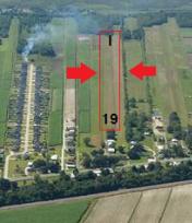
By: Ray Pierce


