Login
Register
MD80
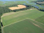
Barren Creek Field Airport
Official FAA Data Effective 2026-02-19 0901Z
VFR Chart of MD80
Sectional Charts at SkyVector.com
IFR Chart of MD80
Enroute Charts at SkyVector.com
Location Information for MD80
Coordinates: N38°27.32' / W75°47.83'View all Airports in Maryland, United States.
Estimated Elevation is 21 feet MSL.
Operations Data
|
|
Airport Communications
| AWOS-3 at CGE (12.0 NW): | 120.675 410-228-7559 |
|---|---|
| ASOS at SBY (15.0 SE): | 118.325 410-341-0868 |
| ATIS at ESN (24.5 NW): | 124.475 |
Nearby Navigation Aids
|
| ||||||||||||||||||||||||||||||||||||||||||||||||||||||||||||
Runway 02/20
| Dimensions: | 2550 x 75 feet / 777 x 23 meters | |
|---|---|---|
| Surface: | Turf | |
| Runway 02 | Runway 20 | |
Ownership Information
| Ownership: | Privately Owned | |
|---|---|---|
| Owner: | BARREN CREEK HOLDINGS, LLC | |
| 23550 TAYLORS TRAIL | ||
| MARDELA SPRINGS, MD 21837 | ||
| 410-845-0794 | ||
| Manager: | JOE COLLINS | |
| 23550 TAYLORS TRAIL | ||
| MARDELA SPRINGS, MD 21837 | ||
| 410-845-0794 | ||
Other Remarks
- FOR CD CTC PATUXENT APCH AT 301-342-3740, WHEN PATUXENT APCH IS CLSD CTC POTOMAC APCH AT 866-640-4124.
Nearby Airports with Instrument Procedures
| ID | Name | Heading / Distance | ||
|---|---|---|---|---|
 |
N06 | Laurel Airport | 061° | 10.9 |
 |
KCGE | Cambridge-Dorchester Regional Airport | 294° | 12.1 |
 |
KSBY | Salisbury-Ocean City Wicomico Regional Airport | 116° | 15.2 |
 |
KESN | Easton/Newnam Field Airport | 328° | 24.5 |
 |
KGED | Delaware Coastal Airport | 055° | 24.9 |
 |
W41 | Crisfield-Somerset County Airport | 183° | 26.2 |
 |
KNHK | Patuxent River NAS (Trapnell Field) Airport | 250° | 30.6 |
 |
KRJD | Gooden Airpark Airport | 354° | 31.0 |
 |
KOXB | Ocean City Municipal Airport | 105° | 32.9 |
 |
KWAL | Wallops Flight Facility Airport | 153° | 34.6 |
 |
2W6 | St Mary's County Regional Airport | 257° | 36.6 |
 |
KTGI | Tangier Island Airport | 194° | 38.9 |


