Login
Register


MDH
Southern Illinois Airport
Official FAA Data Effective 2026-02-19 0901Z
From the Flight Deck
Chart Supplement

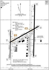
KMDH Airport Diagram
VFR Chart of KMDH
Sectional Charts at SkyVector.com
IFR Chart of KMDH
Enroute Charts at SkyVector.com
Location Information for KMDH
Coordinates: N37°46.68' / W89°15.12'Located 03 miles NW of Carbondale/Murphysboro, Illinois on 1200 acres of land. View all Airports in Illinois.
Surveyed Elevation is 411 feet MSL.
Operations Data
|
|
Airport Communications
| ATIS: | 119.725 |
|---|---|
| ASOS: | Tel. 618-529-1821 |
| SOUTHERN TOWER: | 125.35 126.25 322.4 |
| SOUTHERN GROUND: | 121.8 |
| CTAF: | 125.350 |
| UNICOM: | 122.950 |
| AWOS-3P at MWA (11.5 E): | 119.675 618-942-8877 |
| AWOS-3PT at PCD (29.4 W): | 118.95 573-543-5390 |
| AWOS-3PT at SAR (30.7 NW): | 118.375 618-443-3296 |
- APCH/DEP SVC PRVDD BY KANSAS CITY ARTCC ON FREQS 127.475/346.275 (MARION RCAG).
Nearby Navigation Aids
|
| ||||||||||||||||||||||||||||||||||||||||||||||||||||||||||||


Runway 18L/36R
| Dimensions: | 6506 x 100 feet / 1983 x 30 meters | |
|---|---|---|
| Surface: | Asphalt / Grooved in Excellent Condition | |
| Edge Lighting: | High Intensity | |
| Runway 18L | Runway 36R | |
| Coordinates: | N37°47.31' / W89°14.88' | N37°46.24' / W89°14.90' |
| Elevation: | 404.1 | 397.2 |
| Traffic Pattern: | Left | Left |
| Runway Heading: | 181° True | 1° True |
| Declared Distances: | TORA:6506 TODA:6506 ASDA:6506 LDA:6506 | TORA:6506 TODA:6506 ASDA:6506 LDA:6506 |
| Markings: | Precision Instrument in good condition. | Non-Precision Instrument in good condition. |
| Glide Slope Indicator | P4L (3.00° Glide Path Angle) | |
| Approach Lights: | MALSR 1,400 Foot Medium-intensity Approach Lighting System with runway alignment indicator lights. | |
| REIL: | Yes | |
Runway 06/24
RWY 06/24 NOT AVBL FOR PART 121/PART 380 OPS WITH SKED PAX CARRYING OPS MORE THAN 9 PAX SEATS AND NON-SKED PAX CARRYING OPS MORE THAN 30 PAX SEATS. | ||
| Dimensions: | 4163 x 100 feet / 1269 x 30 meters | |
|---|---|---|
| Surface: | Asphalt / Porous Friction Course in Fair Condition | |
| Weight Limits: | S-86, D-110, ST-167
RSTRD TO ACFT 12500 LBS OR LESS UNLESS PPR WITH ATCT.
PCR VALUE: 350/F/D/X/T
| |
| Edge Lighting: | Medium Intensity | |
| Runway 06 | Runway 24 | |
| Coordinates: | N37°46.53' / W89°15.53' | N37°46.87' / W89°14.77' |
| Elevation: | 410.9 | 405.0 |
| Traffic Pattern: | Left | Left |
| Runway Heading: | 61° True | 241° True |
| Declared Distances: | TORA:4163 TODA:4163 ASDA:4163 LDA:4163 | TORA:4163 TODA:4163 ASDA:4163 LDA:4163 |
| Markings: | Basic in good condition. | Basic in good condition. |
| Glide Slope Indicator | V4L (3.50° Glide Path Angle) | P4R (3.50° Glide Path Angle) |
| REIL: | Yes | Yes |
Runway 18R/36L
RWY 18R/36L NOT AVBL FOR PART 121/PART 380 OPS WITH SKED PAX CARRYING OPS MORE THAN 9 PAX SEATS AND NON-SKED PAX CARRYING OPS MORE THAN 30 PAX SEATS. | ||
| Dimensions: | 3498 x 60 feet / 1066 x 18 meters | |
|---|---|---|
| Surface: | Asphalt in Excellent Condition | |
| Edge Lighting: | Medium Intensity | |
| Runway 18R | Runway 36L | |
| Coordinates: | N37°46.78' / W89°15.51' | N37°46.21' / W89°15.52' |
| Elevation: | 404.8 | 409.9 |
| Runway Heading: | 181° True | 1° True |
| Declared Distances: | TORA:3498 TODA:3498 ASDA:3498 LDA:3498 | TORA:3498 TODA:3498 ASDA:3498 LDA:3498 |
| Markings: | Basic in good condition. | Basic in good condition. |
| Glide Slope Indicator | PSIL (3.00° Glide Path Angle) UNUSBL BYD 6 DEG RIGHT OF COURSE. PVASI OTS INDEF. | PSIL (3.00° Glide Path Angle) |
Services Available
| Fuel: | 100LL (blue), Jet-A |
|---|---|
| Transient Storage: | Hangars,Tiedowns |
| Airframe Repair: | MAJOR |
| Engine Repair: | MAJOR |
| Bottled Oxygen: | NONE |
| Bulk Oxygen: | NONE |
| Other Services: | AIR AMBULANCE SERVICES,CARGO HANDLING SERVICES,CHARTER SERVICE,PILOT INSTRUCTION,AIRCRAFT RENTAL,AIRCRAFT SALES |
Ownership Information
| Ownership: | Publicly owned | |
|---|---|---|
| Owner: | SOUTHERN ILLINOIS ARPT AUTH | |
| PO BOX 1086 | ||
| CARBONDALE, IL 62903 | ||
| 618-529-1721 | ||
| Manager: | ALYSSA CONNELL | |
| P O BOX 1086 | ||
| CARBONDALE, IL 62903 | ||
| 618-529-1721 | ||
Other Remarks
- BIRDS ON & INVOF ARPT.
- HIGH STUDENT TRNG ACTVTY.
- RWY 6 & RWY 18R-36L INTERSECT; VERIFY CORRECT COMPASS HDG FOR RWY 6 DEP.
- ACTVT MALSR RWY 18L; VASI RWY 06; PAPI RWY 24 & 36R; MIRL RWY 06/24; HIRL RWY 18L/36R - CTAF. WHEN ATCT CLSD HIRL RWY 18L/36R PRESET MED INTST; INCREASE INTST - CTAF. WHEN ATCT CLSD 18R/36L LTG BY REQUEST ONLY - CALL 618-534-3662.
Weather Minimums


Instrument Approach Procedure (IAP) Charts


Nearby Airports with Instrument Procedures
| ID | Name | Heading / Distance | ||
|---|---|---|---|---|
 |
KMWA | Veterans Airport of Southern Illinois Airport | 096° | 11.5 |
|
KPJY | Pinckneyville/Du Quoin Airport | 336° | 13.0 |
|
H96 | Benton Municipal Airport | 047° | 20.5 |
|
KPCD | Perryville Regional Airport | 280° | 29.5 |
|
KSAR | Sparta Community-Hunter Field Airport | 316° | 30.7 |
|
KHSB | Harrisburg-Raleigh Airport | 086° | 33.4 |
|
KCGI | Cape Girardeau Regional Airport | 204° | 36.5 |
|
KMVN | Mount Vernon Airport | 029° | 37.6 |
|
KCIR | Cairo Regional Airport | 177° | 42.8 |
|
KENL | Centralia Municipal Airport | 009° | 44.8 |
|
KPAH | Barkley Regional Airport | 151° | 48.7 |
|
H88 | A Paul Vance Fredericktown Regional Airport | 258° | 50.4 |


