Login
Register


H88
A Paul Vance Fredericktown Regional Airport
Official FAA Data Effective 2025-12-25 0901Z
Chart Supplement

VFR Chart of H88
Sectional Charts at SkyVector.com
IFR Chart of H88
Enroute Charts at SkyVector.com
Location Information for H88
Coordinates: N37°36.34' / W90°17.25'Located 03 miles N of Fredericktown, Missouri on 83 acres of land. View all Airports in Missouri.
Surveyed Elevation is 880 feet MSL.
Operations Data
|
|
Airport Communications
| UNICOM: | 122.800 |
|---|---|
| CTAF: | 122.800 |
| AWOS-3PT at FAM (11.6 NW): | 119.275 573-756-6042 |
| AWOS-3PT at PCD (25.6 NE): | 118.95 573-543-5390 |
| AWOS-3PT at PYN (35.4 SW): | 118.475 573-223-2796 |
- APCH/DEP SVC PRVDD BY KANSAS CITY ARTCC ON FREQS 127.475/346.275 (FARMINGTON RCAG).
Nearby Navigation Aids
|
| ||||||||||||||||||||||||||||||||||||||||||||||||||||||||||||


Runway 01/19
| Dimensions: | 4000 x 75 feet / 1219 x 23 meters | |
|---|---|---|
| Surface: | Asphalt in Good Condition | |
| Weight Limits: | S-12 | |
| Edge Lighting: | Medium Intensity | |
| Runway 01 | Runway 19 | |
| Coordinates: | N37°36.02' / W90°17.35' | N37°36.66' / W90°17.14' |
| Elevation: | 874.6 | 875.2 |
| Traffic Pattern: | Left | Left |
| Runway Heading: | 15° True | 195° True |
| Markings: | Non-Precision Instrument in fair condition. | Non-Precision Instrument in fair condition. |
| Glide Slope Indicator | P4L (3.00° Glide Path Angle) | P4L (3.00° Glide Path Angle) |
Services Available
| Fuel: | 100LL (blue), Jet-A |
|---|---|
| Transient Storage: | Tiedowns |
| Airframe Repair: | MAJOR |
| Engine Repair: | MINOR |
| Bottled Oxygen: | NOT AVAILABLE |
| Bulk Oxygen: | NOT AVAILABLE |
Ownership Information
| Ownership: | Publicly owned | |
|---|---|---|
| Owner: | CITY OF FREDERICKTOWN | |
| PO BOX 549 | ||
| FREDRICKTOWN, MO 63645 | ||
| 573-783-3683 | ||
| Manager: | JOEL KEMP | |
| PO BOX 549 | ||
| FREDRICKTOWN, MO 63645 | ||
| (573) 944-4731 | ARPT PHONE - (573) 783-4040 | |
Other Remarks
- WILDLIFE ON & INVOF ARPT.
- 24 HR SS FUEL - 100LL AND JET-A
- FOR CD CTC KANSAS CITY ARTCC AT 913-254-8508.
- ACTVT MIRL RY 01/19 & PAPI RYS 01 & 19 - CTAF.
Weather Minimums
Instrument Approach Procedure (IAP) Charts

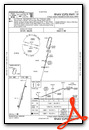
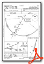
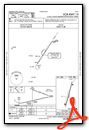
Nearby Airports with Instrument Procedures
| ID | Name | Heading / Distance | ||
|---|---|---|---|---|
 |
KFAM | Farmington Regional Airport | 324° | 11.5 |
|
KPCD | Perryville Regional Airport | 051° | 25.7 |
|
8WC | Washington County Airport | 312° | 28.7 |
|
KCGI | Cape Girardeau Regional Airport | 123° | 41.1 |
|
KSAR | Sparta Community-Hunter Field Airport | 040° | 42.9 |
|
KPJY | Pinckneyville/Du Quoin Airport | 062° | 49.4 |
|
KPOF | Poplar Bluff Regional Business Airport | 182° | 49.9 |
|
KMDH | Southern Illinois Airport | 077° | 50.4 |
|
KDXE | Dexter Municipal Airport | 161° | 52.4 |
|
KSIK | Sikeston Memorial Municipal Airport | 140° | 54.8 |
|
KUUV | Sullivan Regional Airport | 312° | 56.1 |
|
KCPS | St Louis Downtown Airport | 006° | 58.2 |
Airport Images
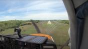
By: Big Orange Bird


