Login
Register


PCD
Perryville Regional Airport
Official FAA Data Effective 2026-02-19 0901Z
Chart Supplement

VFR Chart of KPCD
Sectional Charts at SkyVector.com
IFR Chart of KPCD
Enroute Charts at SkyVector.com
Location Information for KPCD
Coordinates: N37°52.16' / W89°51.71'Located 09 miles N of Perryville, Missouri on 351 acres of land. View all Airports in Missouri.
Surveyed Elevation is 372 feet MSL.
Operations Data
|
|
Airport Communications
| AWOS-3PT: | 118.95 Tel. 573-543-5390 |
|---|---|
| UNICOM: | 122.800 |
| CTAF: | 122.800 |
| AWOS-3PT at SAR (18.5 NE): | 118.375 618-443-3296 |
| AWOS-3PT at FAM (27.7 W): | 119.275 573-756-6042 |
| ATIS at MDH (29.4 E): | 119.725 |
- APCH/DEP SVC PRVDD BY KANSAS CITY ARTCC ON FREQS 127.475/346.275 (FARMINGTON RCAG).
Nearby Navigation Aids
|
| ||||||||||||||||||||||||||||||||||||||||||||||||||||||||||||


Runway 02/20
| Dimensions: | 6483 x 100 feet / 1976 x 30 meters | |
|---|---|---|
| Surface: | Concrete in Good Condition | |
| Weight Limits: | S-28, D-48 | |
| Edge Lighting: | Medium Intensity | |
| Runway 02 | Runway 20 | |
| Coordinates: | N37°51.65' / W89°51.91' | N37°52.67' / W89°51.51' |
| Elevation: | 368.2 | 371.0 |
| Traffic Pattern: | Left | Left |
| Runway Heading: | 17° True | 197° True |
| Declared Distances: | TORA:6483 TODA:6483 ASDA:6483 LDA:6483 | TORA:6483 TODA:6483 ASDA:6483 LDA:6483 |
| Markings: | Non-Precision Instrument in good condition. | Non-Precision Instrument in good condition. |
| Glide Slope Indicator | P4L (3.00° Glide Path Angle) | P4L (3.00° Glide Path Angle) |
| REIL: | Yes | Yes |
| Obstacles: | 16 ft Road 570 ft from runway, 250 ft right of center 50:1 TO DSPLCD THLD. |
|
Services Available
| Fuel: | 100LL (blue), Jet-A |
|---|---|
| Transient Storage: | Hangars,Tiedowns |
| Airframe Repair: | MAJOR |
| Engine Repair: | MAJOR |
| Bottled Oxygen: | NONE |
| Bulk Oxygen: | NONE |
| Other Services: | AVIONICS,CHARTER SERVICE,PILOT INSTRUCTION,AIRCRAFT RENTAL |
Ownership Information
| Ownership: | Publicly owned | |
|---|---|---|
| Owner: | CITY OF PERRYVILLE | |
| 215 N. WEST ST. | ||
| PERRYVILLE, MO 63775 | ||
| 573-547-2594 | ||
| Manager: | BARBARA MAXWELL | |
| 1856 HWY H | ||
| PERRYVILLE, MO 63775 | ||
| 573-605-1856 | ||
Other Remarks
- GEN AVN FACILITIES, FBO & FUEL LOCATED ON W SIDE OF RWY.
- FOR CD CTC KANSAS CITY ARTCC AT 913-254-8508.
- 0LL X2 PUMPS 100LL SELF SERVICE WITH CREDIT CARD - FULL SERVICE JETA FROM TRUCK - CALLOUT FEE $125
- ACTVT MIRL RY 02/20, PAPI RY 20, REIL RYS 02 & 20 - CTAF.
Weather Minimums


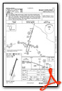
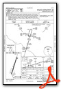
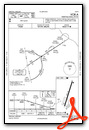
Instrument Approach Procedure (IAP) Charts
Nearby Airports with Instrument Procedures
| ID | Name | Heading / Distance | ||
|---|---|---|---|---|
 |
KSAR | Sparta Community-Hunter Field Airport | 024° | 18.5 |
|
KPJY | Pinckneyville/Du Quoin Airport | 074° | 24.7 |
|
H88 | A Paul Vance Fredericktown Regional Airport | 232° | 25.7 |
|
KFAM | Farmington Regional Airport | 256° | 27.7 |
|
KMDH | Southern Illinois Airport | 100° | 29.5 |
|
KBLV | Scott AFB/Midamerica St Louis Airport | 001° | 40.5 |
|
KMWA | Veterans Airport of Southern Illinois Airport | 099° | 41.0 |
|
KCGI | Cape Girardeau Regional Airport | 160° | 41.0 |
|
8WC | Washington County Airport | 275° | 41.5 |
|
KCPS | St Louis Downtown Airport | 341° | 44.2 |
|
H96 | Benton Municipal Airport | 078° | 44.8 |
|
KENL | Centralia Municipal Airport | 043° | 53.2 |
Airport Images
Do you have a recent image of this airport? Upload it here!


