Login
Register


MKL
Mc Kellar-Sipes Regional Airport
Official FAA Data Effective 2024-11-28 0901Z
Chart Supplement

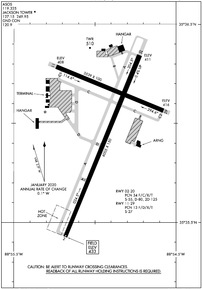
KMKL Airport Diagram
VFR Chart of KMKL
Sectional Charts at SkyVector.com
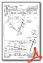
IFR Chart of KMKL
Enroute Charts at SkyVector.com
Location Information for KMKL
Coordinates: N35°35.99' / W88°54.94'Located 04 miles W of Jackson, Tennessee on 807 acres of land. View all Airports in Tennessee.
Surveyed Elevation is 433 feet MSL.
Operations Data
|
|
Airport Communications
| ASOS: | 119.325 Tel. 731-424-0692 |
|---|---|
| JACKSON TOWER: | 127.15 249.95 |
| JACKSON GROUND: | 120.9 |
| UNICOM: | 122.950 |
| NG OPS: | 138.75 373.9 41.5FM |
| CTAF: | 127.150 |
| AWOS-3 at M08 (23.9 S): | 121.125 731-658-6436 |
| AWOS-3 at SZY (31.4 SE): | 118.425 731-645-8184 |
| AWOS-3 at M04 (32.7 W): | 118.575 901-476-1705 |
- APCH/DEP SVC PRVDD BY MEMPHIS ARTCC ON FREQS 134.65/316.15 (MCKELLAR RCAG).
Nearby Navigation Aids
|
| ||||||||||||||||||||||||||||||||||||||||||||||||||||||


Runway 02/20
| Dimensions: | 6005 x 150 feet / 1830 x 46 meters | |
|---|---|---|
| Surface: | Asphalt / Grooved in Excellent Condition FADED. GROOVED 55 FT EACH SIDE OF CNTRLN. | |
| Weight Limits: | S-55, D-80, ST-125
PCR VALUE: 1230/F/C/X/T
| |
| Edge Lighting: | High Intensity | |
| Runway 02 | Runway 20 | |
| Coordinates: | N35°35.43' / W88°55.18' | N35°36.34' / W88°54.72' |
| Elevation: | 433.3 | 411.2 |
| Traffic Pattern: | Left | Left |
| Runway Heading: | 22° True | 202° True |
| Markings: | Precision Instrument in fair condition. | Non-Precision Instrument in fair condition. |
| Glide Slope Indicator | P4L (3.00° Glide Path Angle) PAPI UNUSBL BYD 8 DEG LEFT AND RIGHT OF CNTRLN. | P4L (3.00° Glide Path Angle) |
| Approach Lights: | MALSR 1,400 Foot Medium-intensity Approach Lighting System with runway alignment indicator lights. | |
| Obstacles: | 40 ft Tree 1400 ft from runway, 600 ft right of center | |
Runway 11/29
| Dimensions: | 3539 x 100 feet / 1079 x 30 meters | |
|---|---|---|
| Surface: | Asphalt in Fair Condition FADED. | |
| Weight Limits: | 13 /F/D/X/T, S-27 | |
| Edge Lighting: | Medium Intensity | |
| Runway 11 | Runway 29 | |
| Coordinates: | N35°36.29' / W88°55.24' | N35°36.06' / W88°54.58' |
| Elevation: | 407.6 | 415.7 |
| Traffic Pattern: | Left | Left |
| Runway Heading: | 112° True | 292° True |
| Markings: | Basic in fair condition. | Basic in fair condition. |
| Glide Slope Indicator | P4L (3.00° Glide Path Angle) | P4L (3.00° Glide Path Angle) |
| Obstacles: | 66 ft Tree 1650 ft from runway, 50 ft right of center | 45 ft Tree 1100 ft from runway, 320 ft left of center |
Services Available
| Fuel: | 100LL (blue), Jet-A |
|---|---|
| Transient Storage: | Hangars,Tiedowns |
| Airframe Repair: | MAJOR |
| Engine Repair: | MAJOR |
| Bottled Oxygen: | NOT AVAILABLE |
| Bulk Oxygen: | NOT AVAILABLE |
| Other Services: | AIR FREIGHT SERVICES,AVIONICS,CHARTER SERVICE,PILOT INSTRUCTION,AIRCRAFT RENTAL,AIRCRAFT SALES |
Ownership Information
| Ownership: | Publicly owned | |
|---|---|---|
| Owner: | JACKSON & MADISON CO ARPT AUTH | |
| 308 GRADY MONTGOMERY DR | ||
| JACKSON, TN 38301 | ||
| 731-423-0995 | ||
| Manager: | STEVE SMITH | |
| 308 GRADY MONTGOMERY DR | ||
| JACKSON, TN 38301 | ||
| 731-423-0995 | ||
Other Remarks
- BASE OPS 0630-1600 MON-FRI; PPR C731-425-5600.
- PPR FOR GND ACCESS TO FLD 2130-0600 - 731-394-1755.
- ACR OPS MORE THAN 9 PAX SEATS NA IN EXCESS OF 15 MIN BFR OR AFT SKED ARR OR DEP TIMES WO PRIOR AVBLTY COORD WITH AMGR & CFM.
- FOR CD CTC MEMPHIS ARTCC AT 901-368-8453/8449.
- WHEN ATCT CLSD ACTVT MALSR RWY 02; HIRL RWY 02/20, MIRL RWY 11/29 - CTAF.
Weather Minimums
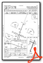
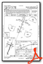
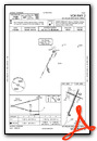
Instrument Approach Procedure (IAP) Charts
Nearby Airports with Instrument Procedures
| ID | Name | Heading / Distance | ||
|---|---|---|---|---|
 |
M53 | Humboldt Municipal Airport | 009° | 12.3 |
|
KTGC | Gibson County Airport | 009° | 20.2 |
|
M08 | William L Whitehurst Field Airport | 195° | 23.9 |
|
KSZY | Robert Sibley Airport | 139° | 31.4 |
|
M04 | Covington Municipal Airport | 268° | 32.9 |
|
KFYE | Fayette County Airport | 225° | 33.2 |
|
KDYR | Dyersburg Regional Airport | 315° | 33.8 |
|
KPVE | Beech River Regional Airport | 084° | 35.4 |
|
KHZD | Carroll County Airport | 036° | 36.7 |
|
KSNH | Savannah-Hardin County Airport | 126° | 42.9 |
|
KCRX | Roscoe Turner Airport | 159° | 43.8 |
|
0M4 | Benton County Airport | 057° | 45.7 |
Airport Images

By: Big Orange Bird


