Login
Register


MML
Southwest Minnesota Regional Marshall/Ryan Field Airport
Official FAA Data Effective 2025-11-27 0901Z
Chart Supplement

VFR Chart of KMML
Sectional Charts at SkyVector.com
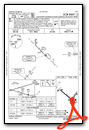
IFR Chart of KMML
Enroute Charts at SkyVector.com
Location Information for KMML
Coordinates: N44°27.10' / W95°49.47'Located 01 miles W of Marshall, Minnesota on 390 acres of land. View all Airports in Minnesota.
Surveyed Elevation is 1182 feet MSL.
Operations Data
|
|
Airport Communications
| AWOS-3PT: | 120.150 Tel. 507-532-5269 |
|---|---|
| CTAF: | 122.800 |
| UNICOM: | 122.800 |
| AWOS-3PT at TKC (15.3 SE): | 120.0 507-629-9006 |
| AWOS-3 at GDB (21.4 NE): | 120.1 320-564-9388 |
| AWOS-3 at CNB (25.2 NW): | 118.575 507-223-5293 |
- APCH/DEP SVC PRVDD BY MINNEAPOLIS ARTCC ON FREQS 127.1/290.2 (REDWOOD FALLS RCAG).
Nearby Navigation Aids
|
| ||||||||||||||||||||||||||||||||||||||||||||||||||||||||||||


Runway 12/30
| Dimensions: | 7221 x 100 feet / 2201 x 30 meters | |
|---|---|---|
| Surface: | Asphalt in Fair Condition | |
| Weight Limits: | 27 /F/B/X/T, S-72, D-105 | |
| Edge Lighting: | High Intensity | |
| Runway 12 | Runway 30 | |
| Coordinates: | N44°27.51' / W95°50.29' | N44°26.75' / W95°49.01' |
| Elevation: | 1182.6 | 1178.5 |
| Traffic Pattern: | Left | Left |
| Runway Heading: | 130° True | 310° True |
| Markings: | Precision Instrument in good condition. | Precision Instrument in good condition. |
| Glide Slope Indicator | P4L (3.00° Glide Path Angle) | P4L (3.00° Glide Path Angle) |
| Approach Lights: | MALSR 1,400 Foot Medium-intensity Approach Lighting System with runway alignment indicator lights. | MALSF 1,400 Foot Medium-intensity Approach Lighting System with sequenced flashers. |
| Obstacles: | 9 ft Crops 319 ft from runway, 354 ft right of center | |
Runway 02/20
| Dimensions: | 3999 x 75 feet / 1219 x 23 meters | |
|---|---|---|
| Surface: | Asphalt in Fair Condition | |
| Edge Lighting: | Medium Intensity | |
| Runway 02 | Runway 20 | |
| Coordinates: | N44°26.76' / W95°49.35' | N44°27.34' / W95°48.92' |
| Elevation: | 1179.9 | 1172.0 |
| Traffic Pattern: | Left | Left |
| Runway Heading: | 28° True | 208° True |
| Markings: | Non-Precision Instrument in fair condition. | Non-Precision Instrument in fair condition. |
| Glide Slope Indicator | P4L (3.00° Glide Path Angle) | P4L (3.00° Glide Path Angle) |
| REIL: | Yes | Yes |
Services Available
| Fuel: | 100LL (blue), Jet-A |
|---|---|
| Transient Storage: | Hangars,Tiedowns |
| Airframe Repair: | MAJOR |
| Engine Repair: | MAJOR |
| Bottled Oxygen: | NONE |
| Bulk Oxygen: | NONE |
| Other Services: | AIR FREIGHT SERVICES,CROP DUSTING SERVICES,AIR AMBULANCE SERVICES,CHARTER SERVICE,PILOT INSTRUCTION,AIRCRAFT RENTAL,AIRCRAFT SALES |
Ownership Information
| Ownership: | Publicly owned | |
|---|---|---|
| Owner: | CITY OF MARSHALL | |
| 344 W MAIN ST | ||
| MARSHALL, MN 56258-1313 | ||
| 507-537-6760 | ||
| Manager: | JASON ANDERSON | |
| 344 W MAIN ST | ||
| MARSHALL, MN 56258-1313 | ||
| 507-537-6773 | ||
Other Remarks
- GCO AVBL ON FREQ 121.725 THRU MINNEAPOLIS ARTCC & FLT SVCS.
- FOR CD IF UNA TO CTC ON FSS FREQ, CTC MINNEAPOLIS ARTCC AT 651-463-5588.
- 0LL FUEL AVBL H24 SELF SVC VIA CREDIT CARD.
- ACTVT MALSR RWY 12; MALSF RWY 30; REIL RWY 02 & 20; PAPI RWY 12, 30, 02, & 20; HIRL RWY 12/30; MIRL RWY 02/20 - CTAF.
Weather Minimums

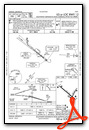
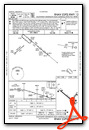
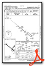
Instrument Approach Procedure (IAP) Charts
Nearby Airports with Instrument Procedures
| ID | Name | Heading / Distance | ||
|---|---|---|---|---|
 |
KTKC | Tracy Municipal Airport | 142° | 15.3 |
|
KGDB | Granite Falls Municipal/Lenzen-Roe-Fagen Memorial Field Airport | 032° | 21.4 |
|
KCNB | Myers Field Airport | 311° | 25.2 |
|
KDVP | Slayton Municipal Airport | 176° | 28.0 |
|
KMVE | Montevideo-Chippewa County Airport | 008° | 31.4 |
|
KRWF | Redwood Falls Municipal Airport | 079° | 32.4 |
|
KPQN | Pipestone Municipal Airport | 216° | 34.9 |
|
KDXX | Lac Qui Parle County Airport | 334° | 35.5 |
|
D42 | Springfield Municipal Airport | 110° | 37.9 |
|
KOVL | Olivia Regional Airport | 059° | 39.2 |
|
KBKX | Brookings Regional Airport | 258° | 43.7 |
|
KMWM | Windom Municipal Airport | 136° | 44.7 |
Airport Images
Do you have a recent image of this airport? Upload it here!


Comments
Good Gas Stop, but That’s It
We stopped here on the way home from Oshkosh 2023 because the self-serve 100LL price was low. The facilities listed for pilot use are all in the terminal used for commercial flights which is a 200-300 yard walk from the fuel pump. Nice facility, however the vending machines were taken out for Covid in 2020 and never replaced, so there are only water fountains. No courtesy cars, so it would have cost $48 to rent a car to run into town or you can take a taxi. Luckily there is DoorDash unless you arrive too early before things are open. Nice people working in the terminal, but the bottom line is stop there only if you need gas and nothing else, or you have lots of extra time.