Login
Register


GDB
Granite Falls Municipal/Lenzen-Roe-Fagen Memorial Field Airport
Official FAA Data Effective 2025-11-27 0901Z
Chart Supplement

VFR Chart of KGDB
Sectional Charts at SkyVector.com
IFR Chart of KGDB
Enroute Charts at SkyVector.com
Location Information for KGDB
Coordinates: N44°45.15' / W95°33.33'Located 04 miles S of Granite Falls, Minnesota on 152 acres of land. View all Airports in Minnesota.
Surveyed Elevation is 1047 feet MSL.
Operations Data
|
|
Airport Communications
| AWOS-3: | 120.1 Tel. 320-564-9388 |
|---|---|
| UNICOM: | 122.800 |
| CTAF: | 122.800 |
| AWOS-3PT at MVE (14.5 NW): | 119.675 320-269-5830 |
| AWOS-3PT at MML (21.4 SW): | 120.150 507-532-5269 |
| AWOS-3 at OVL (22.3 E): | 119.275 320-523-5924 |
- APCH/DEP SVC PRVDD BY MINNEAPOLIS ARTCC ON FREQS 127.1/290.2 (REDWOOD FALLS RCAG).
Nearby Navigation Aids
|
| ||||||||||||||||||||||||||||||||||||||||||||||||


Runway 15/33
| Dimensions: | 4357 x 75 feet / 1328 x 23 meters | |
|---|---|---|
| Surface: | Asphalt in Good Condition | |
| Edge Lighting: | Medium Intensity | |
| Runway 15 | Runway 33 | |
| Coordinates: | N44°45.48' / W95°33.53' | N44°44.82' / W95°33.14' |
| Elevation: | 1047.3 | 1039.8 |
| Runway Heading: | 157° True | 337° True |
| Displaced Threshold: | 642 Feet | |
| Markings: | Non-Precision Instrument in good condition. | Non-Precision Instrument in good condition. |
| Glide Slope Indicator | P4L (3.00° Glide Path Angle) | P4L (3.00° Glide Path Angle) |
| REIL: | Yes | Yes |
| Obstacles: | 21 ft Road 239 ft from runway, 244 ft left of center | |
Services Available
| Fuel: | 100LL (blue) |
|---|---|
| Transient Storage: | Tiedowns |
| Airframe Repair: | NOT AVAILABLE |
| Engine Repair: | NOT AVAILABLE |
| Bottled Oxygen: | NOT AVAILABLE |
| Bulk Oxygen: | NOT AVAILABLE |
| Other Services: | CROP DUSTING SERVICES |
Ownership Information
| Ownership: | Publicly owned | |
|---|---|---|
| Owner: | CITY OF GRANITE FALLS | |
| 641 PRENTICE ST | ||
| GRANITE FALLS, MN 56241-1598 | ||
| 320-564-3011 | ||
| Manager: | LOIS PROCTOR | |
| 641 PRENTICE ST | ||
| GRANITE FALLS, MN 56241-1598 | ||
| 507-476-5939 | ||
Other Remarks
- DEER ON & INVOF AIRPORT.
- NOISE SENSITIVE AREA 1.5 MI IN RADIUS OFF NORTH END OF RY 15/33.
- GCO AVBL ON FREQ 121.725 THRU MINNEAPOLIS ARTCC AND PRINCETON FSS.
- ARPT INFO PHONE NUMBER: 320-564-5665.
- FOR CD IF UNA VIA GCO CTC MINNEAPOLIS ARTCC AT 651-463-5588.
- 0LL SELF SERVICE FUEL AVAIL 24 HOURS WITH CREDIT CARD.
- MIRL RY 15/33 PRESET ON LOW INTST; TO INCR INTST, ACTVT REIL RY 15 & 33 & PAPI RY 15 & 33 - CTAF.
Weather Minimums

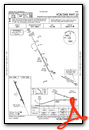
Instrument Approach Procedure (IAP) Charts

Nearby Airports with Instrument Procedures
| ID | Name | Heading / Distance | ||
|---|---|---|---|---|
 |
KMVE | Montevideo-Chippewa County Airport | 333° | 14.6 |
|
KMML | Southwest Minnesota Regional Marshall/Ryan Field Airport | 212° | 21.4 |
|
KOVL | Olivia Regional Airport | 085° | 22.4 |
|
KRWF | Redwood Falls Municipal Airport | 121° | 23.7 |
|
KBDH | Willmar Municipal/John L Rice Field Airport | 039° | 28.4 |
|
KDXX | Lac Qui Parle County Airport | 298° | 30.0 |
|
KTKC | Tracy Municipal Airport | 184° | 30.3 |
|
KCNB | Myers Field Airport | 267° | 30.4 |
|
KAQP | Appleton Municipal Airport | 326° | 34.3 |
|
KBBB | Benson Municipal Airport | 353° | 35.0 |
|
D42 | Springfield Municipal Airport | 142° | 39.4 |
|
KDVP | Slayton Municipal Airport | 192° | 47.0 |
Airport Images
Do you have a recent image of this airport? Upload it here!


