Login
Register


MVE
Montevideo-Chippewa County Airport
Official FAA Data Effective 2026-01-22 0901Z
Chart Supplement

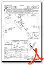
VFR Chart of KMVE
Sectional Charts at SkyVector.com
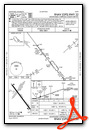
IFR Chart of KMVE
Enroute Charts at SkyVector.com
Location Information for KMVE
Coordinates: N44°58.15' / W95°42.62'Located 02 miles N of Montevideo, Minnesota on 374 acres of land. View all Airports in Minnesota.
Surveyed Elevation is 1034 feet MSL.
Operations Data
|
|
Airport Communications
| AWOS-3PT: | 119.675 Tel. 320-269-5830 |
|---|---|
| UNICOM: | 122.800 |
| CTAF: | 122.800 |
| AWOS-3 at GDB (14.6 SE): | 120.1 320-564-9388 |
| AWOS-3 at DXX (19.9 W): | 118.975 320-598-3863 |
| AWOS-3 at AQP (19.9 NW): | 118.5 320-289-1265 |
- APCH/DEP SVC PRVDD BY MINNEAPOLIS ARTCC ON FREQS 125.5/323.1 (DARWIN RCAG).
Nearby Navigation Aids
|
| ||||||||||||||||||||||||||||||||||||||||||||||||


Runway 14/32
| Dimensions: | 3999 x 75 feet / 1219 x 23 meters | |
|---|---|---|
| Surface: | Asphalt in Fair Condition | |
| Weight Limits: | S-12 | |
| Edge Lighting: | Medium Intensity | |
| Runway 14 | Runway 32 | |
| Coordinates: | N44°58.36' / W95°42.87' | N44°57.84' / W95°42.30' |
| Elevation: | 1034.0 | 1019.6 |
| Traffic Pattern: | Left | Left |
| Runway Heading: | 143° True | 323° True |
| Markings: | Non-Precision Instrument in good condition. | Non-Precision Instrument in good condition. |
| Glide Slope Indicator | P4L (3.00° Glide Path Angle) | P4L (3.00° Glide Path Angle) |
| REIL: | Yes | Yes |
Runway 03/21
| Dimensions: | 2361 x 165 feet / 720 x 50 meters | |
|---|---|---|
| Surface: | Turf in Good Condition | |
| Runway 03 | Runway 21 | |
| Coordinates: | N44°58.09' / W95°42.86' | N44°58.40' / W95°42.52' |
| Elevation: | 1034.0 | 1021.9 |
| Traffic Pattern: | Left | Left |
| Runway Heading: | 38° True | 218° True |
| Obstacles: | 7 ft Brush 133 ft from runway, 138 ft right of center | |
Services Available
| Fuel: | 100LL (blue) |
|---|---|
| Transient Storage: | Hangars,Tiedowns |
| Airframe Repair: | MAJOR |
| Engine Repair: | MAJOR |
| Bottled Oxygen: | NONE |
| Bulk Oxygen: | NONE |
| Other Services: | CROP DUSTING SERVICES,AIRCRAFT SALES |
Ownership Information
| Ownership: | Publicly owned | |
|---|---|---|
| Owner: | CITY OF MONTEVIDEO | AND CHIPPEWA COUNTY. |
| 103 CANTON AVE;, PO BOX 517 | ||
| MONTEVIDEO, MN 56265 | ||
| 320-269-6575 | ||
| Manager: | MARK BORGERSON | |
| P.O. BOX 154, 1902 BENSON RD | ||
| MONTEVIDEO, MN 56265 | ||
| 320-269-4829 | ||
Other Remarks
- RWY 03/21 NOT PLOWED WINTER MONTHS.
- ULTRALIGHTS ON AND INVOF ARPT.
- FOR CD IF UNA TO CTC ON FSS FREQ, CTC MINNEAPOLIS ARTCC AT 651-463-5588.
- RY 03/21 THRS & EDGES MARKED WITH YELLOW CONES.
- 0LL FUEL SELF SVC 24 HRS WITH CREDIT CARD.
- MIRL PRESET TO LOW SS-SR. TO INCR INTSY AND ACTVT REIL RY 14/32 & PAPI RY 14/32 - CTAF.
Weather Minimums


Instrument Approach Procedure (IAP) Charts
Nearby Airports with Instrument Procedures
| ID | Name | Heading / Distance | ||
|---|---|---|---|---|
 |
KGDB | Granite Falls Municipal/Lenzen-Roe-Fagen Memorial Field Airport | 153° | 14.6 |
|
KDXX | Lac Qui Parle County Airport | 273° | 19.9 |
|
KAQP | Appleton Municipal Airport | 321° | 19.9 |
|
KBBB | Benson Municipal Airport | 006° | 21.9 |
|
KBDH | Willmar Municipal/John L Rice Field Airport | 070° | 26.3 |
|
KCNB | Myers Field Airport | 238° | 27.7 |
|
KOVL | Olivia Regional Airport | 111° | 31.1 |
|
KMML | Southwest Minnesota Regional Marshall/Ryan Field Airport | 188° | 31.4 |
|
KVVV | Ortonville Municipal/Martinson Field Airport | 303° | 36.4 |
|
KRWF | Redwood Falls Municipal Airport | 133° | 36.9 |
|
KMOX | Morris Municipal/Charlie Schmidt Field Airport | 343° | 37.3 |
|
1D1 | Milbank Municipal Airport | 293° | 39.6 |
Airport Images
Do you have a recent image of this airport? Upload it here!


