Login
Register


D42
Springfield Municipal Airport
Official FAA Data Effective 2026-01-22 0901Z
Chart Supplement

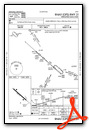
VFR Chart of D42
Sectional Charts at SkyVector.com
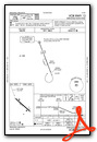
IFR Chart of D42
Enroute Charts at SkyVector.com
Location Information for D42
Coordinates: N44°13.86' / W94°59.94'Located 01 miles SW of Springfield, Minnesota on 118 acres of land. View all Airports in Minnesota.
Surveyed Elevation is 1073 feet MSL.
Operations Data
|
|
Airport Communications
| CTAF: | 122.800 |
|---|---|
| UNICOM: | 122.800 |
| ASOS at RWF (19.3 N): | 126.575 507-644-3564 |
| AWOS-3PT at MWM (19.8 S): | 119.325 507-831-1833 |
| AWOS-3 at ULM (22.0 E): | 118.325 507-359-1656 |
- APCH/DEP SVC PRVDD BY MINNEAPOLIS ARTCC ON FREQS 127.1/290.2 (REDWOOD FALLS RCAG).
Nearby Navigation Aids
|
| ||||||||||||||||||||||||||||||||||||||||||||||||||||||||||||


Runway 13/31
| Dimensions: | 3402 x 75 feet / 1037 x 23 meters | |
|---|---|---|
| Surface: | Asphalt in Good Condition | |
| Weight Limits: | S-12 | |
| Edge Lighting: | Medium Intensity NO CAUTION ZONE LIGHTING PRESENT FOR LAST HALF OF RWY IN BOTH DIRECTIONS | |
| Runway 13 | Runway 31 | |
| Coordinates: | N44°14.05' / W95°0.23' | N44°13.68' / W94°59.65' |
| Elevation: | 1070.5 | 1067.4 |
| Traffic Pattern: | Right | Left |
| Runway Heading: | 132° True | 312° True |
| Markings: | Non-Precision Instrument in good condition. | Non-Precision Instrument in good condition. |
| Glide Slope Indicator | P2L (3.00° Glide Path Angle) | P2L (3.00° Glide Path Angle) |
| REIL: | Yes | Yes |
Services Available
| Fuel: | 100LL (blue) |
|---|---|
| Transient Storage: | Hangars,Tiedowns CTC 507-723-3500 FOR HNGR. |
| Airframe Repair: | NONE |
| Engine Repair: | NONE |
| Bottled Oxygen: | NONE |
| Bulk Oxygen: | NONE |
Ownership Information
| Ownership: | Publicly owned | |
|---|---|---|
| Owner: | CITY OF SPRINGFIELD | |
| 2 E CENTRAL ST | ||
| SPRINGFIELD, MN 56087 | ||
| 507-723-3500 | ||
| Manager: | JUSTTINA ERICKSON | |
| 2 E CENTRAL ST | ||
| SPRINGFIELD, MN 56087 | ||
| 507-723-3500 | ||
Other Remarks
- ULTRALIGHT TRAFFIC ON & INVOF ARPT.
- FOR CD CTC MINNEAPOLIS ARTCC AT 651-463-5588.
- 0LL SELF SVC AVBL H24 VIA CREDIT CARD.
- MIRL SS-SR, ACTVT MIRL RWY 13/31, REIL RWY 13/31, AND PAPI RWY 13/31 - CTAF.
Weather Minimums

Instrument Approach Procedure (IAP) Charts

Nearby Airports with Instrument Procedures
| ID | Name | Heading / Distance | ||
|---|---|---|---|---|
 |
KRWF | Redwood Falls Municipal Airport | 349° | 19.3 |
|
KMWM | Windom Municipal Airport | 194° | 19.6 |
|
KULM | New Ulm Municipal Airport | 076° | 22.1 |
|
KJYG | St James Municipal Airport | 127° | 24.1 |
|
KTKC | Tracy Municipal Airport | 272° | 26.3 |
|
KOVL | Olivia Regional Airport | 357° | 32.9 |
|
KMJQ | Jackson Municipal Airport | 179° | 34.8 |
|
KDVP | Slayton Municipal Airport | 246° | 36.9 |
|
KMML | Southwest Minnesota Regional Marshall/Ryan Field Airport | 290° | 37.9 |
|
KGDB | Granite Falls Municipal/Lenzen-Roe-Fagen Memorial Field Airport | 322° | 39.4 |
|
KOTG | Worthington Municipal Airport | 216° | 42.7 |
|
KFRM | Fairmont Municipal Airport | 144° | 43.4 |
Airport Images
Do you have a recent image of this airport? Upload it here!


