Login
Register


MNI
Santee Cooper Regional Airport
Official FAA Data Effective 2026-02-19 0901Z
Chart Supplement

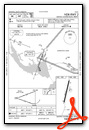
VFR Chart of KMNI
Sectional Charts at SkyVector.com
IFR Chart of KMNI
Enroute Charts at SkyVector.com
Location Information for KMNI
Coordinates: N33°35.23' / W80°12.52'Located 07 miles S of Manning, South Carolina on 67 acres of land. View all Airports in South Carolina.
Surveyed Elevation is 102 feet MSL.
Operations Data
|
|
Airport Communications
| AWOS-3: | 120.175 Tel. 803-478-6060 |
|---|---|
| SHAW APPROACH: | 125.4 318.1 |
| SHAW DEPARTURE: | 125.4 318.1 |
| UNICOM: | 122.800 |
| CTAF: | 122.800 |
| AWOS-3 at CKI (19.2 NE): | 124.775 843-382-3000 |
| AWOS-3 at MKS (25.5 S): | 119.175 843-761-1486 |
| AWOS-3 at SMS (25.6 N): | 118.075 803-469-6750 |
- APCH/DEP SVC PRVDD BY JACKSONVILLE ARTCC ON FREQS 124.7/269.55 (COLUMBIA RCAG) WHEN SHAW APCH CTL CLSD.
Nearby Navigation Aids
|
| ||||||||||||||||||||||||||||||||||||||||||||||||||||||||||||


Runway 02/20
| Dimensions: | 3602 x 75 feet / 1098 x 23 meters | |
|---|---|---|
| Surface: | Asphalt in Good Condition | |
| Weight Limits: | S-30 | |
| Edge Lighting: | Medium Intensity | |
| Runway 02 | Runway 20 | |
| Coordinates: | N33°34.94' / W80°12.59' | N33°35.52' / W80°12.45' |
| Elevation: | 94.4 | 102.7 |
| Traffic Pattern: | Left | Left |
| Runway Heading: | 12° True | 192° True |
| Markings: | Non-Precision Instrument in good condition. | Non-Precision Instrument in good condition. |
| Glide Slope Indicator | P2L (4.00° Glide Path Angle) | P2L (4.00° Glide Path Angle) |
| Obstacles: | 50 ft Tree 1153 ft from runway, 230 ft right of center | 58 ft Tree 1471 ft from runway, 93 ft right of center |
Services Available
| Fuel: | 100LL (blue), Jet-A |
|---|---|
| Transient Storage: | Tiedowns |
| Airframe Repair: | MAJOR |
| Engine Repair: | MINOR |
| Bottled Oxygen: | NONE |
| Bulk Oxygen: | NONE |
| Other Services: | AVIONICS,GLIDER SERVICE |
Ownership Information
| Ownership: | Publicly owned | |
|---|---|---|
| Owner: | CLARENDON COUNTY | |
| PO BOX 486 | ||
| MANNING, SC 29102 | ||
| 803-435-8424 | ||
| Manager: | MS. VICKIE WILLIAMS | |
| 8606 HIGHWAY 260 | ||
| MANNING, SC 29102 | ||
| 803-433-4004 | ||
Other Remarks
- GLIDER OPNS ON & INVOF ARPT.
- FOR CD CTC SHAW APCH AT 803-895-4884, WHEN APCH CLSD CTC JACKSONVILLE ARTCC AT 904-845-1592.
- 0LL SELF SVC 100LL AVBL 24 HRS WITH CREDIT CARD.
- SELF SVC JET-A AVBL 24 HRS WITH CREDIT CARD.
- MIRL PRESET LOW INTST DUSK-2300; TO INCR INTST - CTAF. TO ACTVT AFT 2300 - CTAF.
Weather Minimums

Instrument Approach Procedure (IAP) Charts
Nearby Airports with Instrument Procedures
| ID | Name | Heading / Distance | ||
|---|---|---|---|---|
 |
KCKI | Williamsburg Regional Airport | 066° | 19.3 |
|
KMKS | Berkeley County Airport | 160° | 25.6 |
|
KSMS | Sumter Airport | 342° | 25.6 |
|
KSSC | Shaw AFB Airport | 330° | 26.6 |
|
51J | Lake City Municipal Cj Evans Field Airport | 053° | 27.2 |
|
6J2 | St George Airport | 212° | 27.9 |
|
KDYB | Summerville Airport | 186° | 31.6 |
|
KOGB | Orangeburg Municipal Airport | 256° | 33.6 |
|
KPHH | Robert F Swinnie Airport | 103° | 35.2 |
|
KMMT | Mc Entire Jngb Airport | 304° | 35.7 |
|
KCHS | Charleston AFB/International Airport | 168° | 42.1 |
|
KFLO | Florence Regional Airport | 033° | 43.2 |
Airport Images
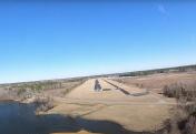
By: Big Orange Bird


