Login
Register


SEP
Stephenville Clark Regional Airport
Official FAA Data Effective 2026-02-19 0901Z
Chart Supplement

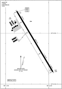
KSEP Airport Diagram
VFR Chart of KSEP
Sectional Charts at SkyVector.com
IFR Chart of KSEP
Enroute Charts at SkyVector.com
Location Information for KSEP
Coordinates: N32°12.92' / W98°10.66'Located 01 miles E of Stephenville, Texas on 160 acres of land. View all Airports in Texas.
Surveyed Elevation is 1321 feet MSL.
Operations Data
|
|
Airport Communications
| AWOS-3PT: | 118.075 Tel. 254-965-8672 |
|---|---|
| CTAF: | 122.800 |
| UNICOM: | 122.800 |
| AWOS-3T at GDJ (23.0 NE): | 118.925 817-573-7514 |
| AWOS-3PT at 6P9 (24.8 NW): | 118.8 254-647-3618 |
| AWOS-3 at MKN (27.6 SW): | 118.575 325-356-7032 |
- APCH/DEP SVC PRVDD BY FORT WORTH ARTCC (ZFW) ON FREQS 135.375/354.05 (DUBLIN RCAG).
Nearby Navigation Aids
|
| ||||||||||||||||||||||||||||||||||||||||||||||||||||||||||||


Runway 14/32
| Dimensions: | 4209 x 75 feet / 1283 x 23 meters | |
|---|---|---|
| Surface: | Asphalt in Good Condition | |
| Edge Lighting: | Medium Intensity | |
| Runway 14 | Runway 32 | |
| Coordinates: | N32°13.22' / W98°10.87' | N32°12.62' / W98°10.45' |
| Elevation: | 1321.4 | 1289.2 |
| Traffic Pattern: | Left | Left |
| Runway Heading: | 149° True | 329° True |
| Markings: | Non-Precision Instrument in good condition. | Non-Precision Instrument in good condition. |
| Glide Slope Indicator | P2L PAPI OTS INDEFLY. | P2L PAPI OTS INDEFLY. |
| Obstacles: | 40 ft Tree 915 ft from runway 15 FT. BRUSH, 0-199 FT DSTC, 230 FT L. |
55 ft Trees 201 ft from runway, 220 ft left of center 12 FT TREES AND BRUSH 193 FT DSTC 0 FT B. |
Services Available
| Fuel: | 100LL (blue), Jet A+ |
|---|---|
| Transient Storage: | Tiedowns |
| Airframe Repair: | MAJOR |
| Engine Repair: | MAJOR |
| Bottled Oxygen: | NONE |
| Bulk Oxygen: | NONE |
| Other Services: | PILOT INSTRUCTION,PARACHUTE JUMP ACTIVITY,AIRCRAFT RENTAL |
Ownership Information
| Ownership: | Publicly owned | |
|---|---|---|
| Owner: | CITY OF STEPHENVILLE | |
| 298 W. WASHINGTON ST | ||
| STEPHENVILLE, TX 76401 | ||
| 254-918-1294 | ||
| Manager: | SEAN CLEMMONS | |
| 1050 AIRPORT ROAD | ||
| STEPHENVILLE, TX 76401 | ||
| 254-552-1224 | AMGR CELL: 254-964-6804 | |
Other Remarks
- THIS AIRPORT HAS BEEN SURVEYED BY THE NATIONAL GEODETIC SURVEY.
- FOR CD CTC FORT WORTH ARTCC AT 817-858-7584.
- SKYDIVING AND PARACHUTE ACTVTY ON AND INVOF ARPT.
- PRKG AT SELF-SVC FUEL PUMPS FOR RFLG ACFT ONLY. PRKG UNATNDD ACFT AT SELF-SVC FUEL PUMPS IS PROHIBITED.
- RWY 14 PREF WITH CALM WINDS.
- DEER INVOF ARPT.
- 0LL 100LL SELF-SERVE ONLY
Weather Minimums


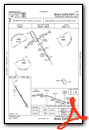
Instrument Approach Procedure (IAP) Charts

Nearby Airports with Instrument Procedures
| ID | Name | Heading / Distance | ||
|---|---|---|---|---|
 |
KGDJ | Granbury Regional Airport | 052° | 22.7 |
|
KMKN | Comanche County-City Airport | 230° | 27.8 |
|
KMNZ | Hamilton Municipal Airport | 177° | 32.9 |
|
KETN | Eastland Municipal Airport | 290° | 34.3 |
|
KMWL | Mineral Wells Regional Airport | 009° | 34.4 |
|
50F | Bourland Field Airport | 053° | 37.0 |
|
KCPT | Cleburne Regional Airport | 077° | 38.7 |
|
KWEA | Parker County Airport | 038° | 40.5 |
|
KGZN | Gregory M Simmons Memorial Airport | 282° | 44.0 |
|
F35 | Possum Kingdom Airport | 342° | 44.4 |
|
KBWD | Brownwood Regional Airport | 237° | 47.1 |
|
KBKD | Stephens County Airport | 309° | 47.1 |
Airport Images
By: jahangiriali


