Login
Register


F35
Possum Kingdom Airport
Official FAA Data Effective 2026-02-19 0901Z
Chart Supplement

VFR Chart of F35
Sectional Charts at SkyVector.com
IFR Chart of F35
Enroute Charts at SkyVector.com
Location Information for F35
Coordinates: N32°55.40' / W98°26.21'Located 12 miles SW of Graford, Texas on 59 acres of land. View all Airports in Texas.
Surveyed Elevation is 1008 feet MSL.
Operations Data
|
|
Airport Communications
| CTAF: | 122.900 |
|---|---|
| AWOS-3P at RPH (12.6 NW): | 118.025 940-521-0685 |
| ASOS at MWL (20.8 SE): | 135.075 940-325-2457 |
| AWOS-3 at BKD (26.0 SW): | 120.175 254-559-5525 |
- APCH/DEP CTL SVC PRVDD BY FORT WORTH ARTCC (ZFW) ON FREQS 127.0/360.6 (MINERAL WELLS RCAG).
Nearby Navigation Aids
|
| ||||||||||||||||||||||||||||||||||||||||||||||||||||||||||||


Runway 02/20
| Dimensions: | 3500 x 60 feet / 1067 x 18 meters | |
|---|---|---|
| Surface: | Asphalt in Fair Condition | |
| Weight Limits: | S-24 | |
| Edge Lighting: | Medium Intensity | |
| Runway 02 | Runway 20 | |
| Coordinates: | N32°55.15' / W98°26.39' | N32°55.65' / W98°26.04' |
| Elevation: | 1008.1 | 1008.3 |
| Runway Heading: | 31° True | 211° True |
| Markings: | Basic in fair condition. | Basic in fair condition. |
| Glide Slope Indicator | P2L (3.50° Glide Path Angle) | P2L (3.50° Glide Path Angle) |
| Obstacles: | 5 ft Trees 200 ft from runway, 217 ft left of center ALSO 5 FT FENCE, 200 FT DSTC, 168 FT R. 12 FT TREE, 0 FT DSTC, 250 FT R. |
56 ft Trees 200 ft from runway, 246 ft right of center 75 FT TREE 150 FT DSTC 234 FT R; 27 FT PLINE, 100 FT DSTC, 235 FT R. |
Services Available
| Fuel: | NONE |
|---|---|
| Transient Storage: | Tiedowns |
| Airframe Repair: | NOT AVAILABLE |
| Engine Repair: | NOT AVAILABLE |
| Bottled Oxygen: | NOT AVAILABLE |
| Bulk Oxygen: | NOT AVAILABLE |
Ownership Information
| Ownership: | Publicly owned | |
|---|---|---|
| Owner: | BRAZOS RIVER AUTHORITY | |
| 4400 COBBS DRIVE | ||
| WACO, TX 76710 | ||
| 254-776-1441 | ||
| Manager: | TROY WEATHERHEAD | |
| 301 OBSERVATION POINT ROAD | ||
| GRAFORD, TX 76449 | ||
| 940-779-2321 | ||
Other Remarks
- WILDLIFE INVOF ARPT.
- FOR CD CTC FORT WORTH ARTCC AT 817-858-7584.
- ACTVT MIRL RWY 02/20 - CTAF.
Weather Minimums

Instrument Approach Procedure (IAP) Charts
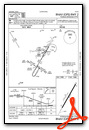
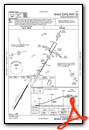
Nearby Airports with Instrument Procedures
| ID | Name | Heading / Distance | ||
|---|---|---|---|---|
 |
KRPH | Graham Municipal Airport | 332° | 12.7 |
|
KMWL | Mineral Wells Regional Airport | 113° | 20.8 |
|
KBKD | Stephens County Airport | 242° | 26.1 |
|
KONY | Olney Municipal Airport | 323° | 32.0 |
|
KXBP | Bridgeport Municipal Airport | 063° | 34.2 |
|
KETN | Eastland Municipal Airport | 211° | 35.8 |
|
KWEA | Parker County Airport | 105° | 39.6 |
|
KGDJ | Granbury Regional Airport | 132° | 42.4 |
|
T23 | Albany Municipal Airport | 254° | 43.7 |
|
KSEP | Stephenville Clark Regional Airport | 162° | 44.4 |
|
KGZN | Gregory M Simmons Memorial Airport | 221° | 44.7 |
|
50F | Bourland Field Airport | 115° | 47.4 |
Airport Images

By: safetyfly


