Login
Register


N38
Grand Canyon Regional Airport
Official FAA Data Effective 2025-12-25 0901Z
Chart Supplement

VFR Chart of N38
Sectional Charts at SkyVector.com
IFR Chart of N38
Enroute Charts at SkyVector.com
Location Information for N38
Coordinates: N41°43.68' / W77°23.73'Located 04 miles SW of Wellsboro, Pennsylvania on 112 acres of land. View all Airports in Pennsylvania.
Surveyed Elevation is 1891 feet MSL.
Operations Data
|
|
Airport Communications
| AWOS-3PT: | 120.925 Tel. 570-723-0385 |
|---|---|
| ELMIRA APPROACH: | 128.425 257.8 |
| ELMIRA DEPARTURE: | 128.425 257.8 |
| UNICOM: | 122.800 |
| CTAF: | 122.800 |
| ATIS at ELM (34.3 NE): | 125.475 |
| ASOS at ELM (34.5 NE): | 607-796-0065 |
| ASOS at ELZ (34.8 NW): | 119.275 585-593-0203 |
- APCH/DEP SVC PRVDD BY NEW YORK ARTCC ON FREQS 133.35/372.0 (SAYRE RCAG) WHEN ELMIRA APCH CTL CLSD.
Nearby Navigation Aids
|
| ||||||||||||||||||||||||||||||||||||||||||


Runway 10/28
| Dimensions: | 3597 x 60 feet / 1096 x 18 meters | |
|---|---|---|
| Surface: | Asphalt in Fair Condition | |
| Edge Lighting: | Medium Intensity | |
| Runway 10 | Runway 28 | |
| Coordinates: | N41°43.66' / W77°24.19' | N41°43.68' / W77°23.40' |
| Elevation: | 1889.3 | 1881.1 |
| Traffic Pattern: | Left | Left |
| Runway Heading: | 88° True | 268° True |
| Markings: | Non-Precision Instrument in fair condition. | Non-Precision Instrument in fair condition. |
| REIL: | Yes | |
| Obstacles: | 45 ft Trees 582 ft from runway, 298 ft right of center | |
Runway 11/29
| Dimensions: | 1576 x 80 feet / 480 x 24 meters | |
|---|---|---|
| Surface: | Turf in Good Condition | |
| Runway 11 | Runway 29 | |
| Coordinates: | N41°43.69' / W77°23.75' | N41°43.70' / W77°23.41' |
| Elevation: | 1886.8 | 1877.9 |
| Runway Heading: | 88° True | 268° True |
Services Available
| Fuel: | 100LL (blue), Jet-A |
|---|---|
| Transient Storage: | Hangars,Tiedowns |
| Airframe Repair: | NONE |
| Engine Repair: | NONE |
| Bottled Oxygen: | NONE |
| Bulk Oxygen: | NONE |
Ownership Information
| Ownership: | Publicly owned | |
|---|---|---|
| Owner: | GRAND CANYON ARPT AUTH | |
| 112 RUNWAY RD | ||
| WELLSBORO, PA 16901 | ||
| (570) 724-3746 | ||
| Manager: | SHAW SIGLIN | |
| 112 RUNWAY ROAD | ||
| WELLSBORO, PA 16901 | ||
| (570) 724-3746 | (570) 439-8103 | |
Other Remarks
- TURF RWY 11/29 1600 FT X 100 FT DAY VFR ONLY; NON SIMULTANEOUS OPS; CLSD ANNUALLY DEC-APR.
- FOR CD CTC NEW YORK ARTCC AT 631-468-1425.
- ACTVT REIL RWY 28; MIRL 10/28 - CTAF.
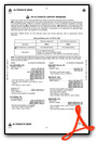
Weather Minimums
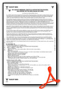
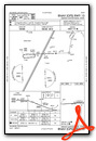
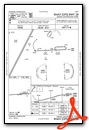
Instrument Approach Procedure (IAP) Charts
Nearby Airports with Instrument Procedures
| ID | Name | Heading / Distance | ||
|---|---|---|---|---|
 |
KELM | Elmira/Corning Regional Airport | 040° | 34.3 |
|
KELZ | Wellsville Municipal/Tarantine Field Airport | 310° | 35.1 |
|
KLHV | William T Piper Memorial Airport | 181° | 35.5 |
|
KIPT | Williamsport Regional Airport | 143° | 36.1 |
|
KHTF | Hornell Municipal Airport | 342° | 41.3 |
|
N27 | Bradford County Airport | 088° | 42.6 |
|
KDSV | Dansville Municipal Airport | 344° | 52.5 |
|
KOYM | St Marys Municipal Airport | 249° | 53.3 |
|
KOLE | Cattaraugus County-Olean Airport | 305° | 53.4 |
|
N96 | Bellefonte Airport | 200° | 54.0 |
|
KBFD | Bradford Regional Airport | 275° | 56.1 |
|
KUNV | State College Regional Airport | 201° | 56.5 |


