Login
Register


NK17
August Field Airport
Official FAA Data Effective 2026-02-19 0901Z
VFR Chart of NK17
Sectional Charts at SkyVector.com
IFR Chart of NK17
Enroute Charts at SkyVector.com
Location Information for NK17
Coordinates: N43°12.56' / W73°34.90'Located 02 miles E of Gansevoort, New York on 80 acres of land. View all Airports in New York.
Estimated Elevation is 131 feet MSL.
Operations Data
|
|
Airport Communications
| ASOS at GFL (7.8 N): | 119.925 518-743-1728 |
|---|---|
| AWOS-3 at 5B2 (15.6 SW): | 132.025 518-884-9289 |
| ASOS at DDH (23.9 SE): | 135.925 802-442-6059 |
Nearby Navigation Aids
|
| ||||||||||||||||||||||||||||||||||||||||||||||||||||||||||||


Runway 03/21
| Dimensions: | 2100 x 100 feet / 640 x 30 meters | |
|---|---|---|
| Surface: | Turf | |
| Runway 03 | Runway 21 | |
Ownership Information
| Ownership: | Privately Owned | |
|---|---|---|
| Owner: | AUGUST R. FERENCZI | |
| 1442 W. RIVER RD | ||
| GANSEVOORT, NY 12831 | ||
| 917-288-1496 | ||
| Manager: | AUGUST R. FERENCZI | |
| 1442 W. RIVER RD | ||
| GANSEVOORT, NY 12831 | ||
| 917-288-1496 | ||
Other Remarks
- RY IS NOT PLOWED, ARPT CLOSED WINTER MONTHS.
- FOR CD CTC ALBANY APCH AT 518-862-2299.
Nearby Airports with Instrument Procedures
| ID | Name | Heading / Distance | ||
|---|---|---|---|---|
 |
KGFL | Floyd Bennett Memorial Airport | 351° | 8.0 |
|
5B2 | Saratoga County Airport | 232° | 15.6 |
|
KDDH | William H Morse State Airport | 142° | 24.1 |
|
KSCH | Schenectady County Airport | 215° | 26.3 |
|
KALB | Albany International Airport | 199° | 29.3 |
|
KRUT | Rutland/Southern Vermont Regional Airport | 054° | 33.7 |
|
NY0 | Fulton County Airport | 249° | 35.2 |
|
KAQW | Harriman-and-West Airport | 149° | 35.7 |
|
4B0 | South Albany Airport | 196° | 40.5 |
|
4B6 | Ticonderoga Municipal Airport | 010° | 40.7 |
|
K09 | Piseco Airport | 290° | 43.4 |
|
KVSF | Hartness State (Springfield) Airport | 079° | 47.3 |
Airport Images
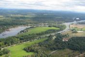
By: rkittine


