Login
Register


OKM
Okmulgee Regional/Paul and Betty Abbott Field Airport
Official FAA Data Effective 2024-07-11 0901Z
Chart Supplement

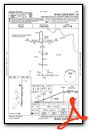
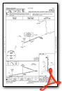
VFR Chart of KOKM
Sectional Charts at SkyVector.com
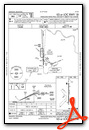
IFR Chart of KOKM
Enroute Charts at SkyVector.com
Location Information for KOKM
Coordinates: N35°40.09' / W95°56.91'Located 03 miles N of Okmulgee, Oklahoma on 1100 acres of land. View all Airports in Oklahoma.
Surveyed Elevation is 719 feet MSL.
Operations Data
|
|
Airport Communications
| AWOS-3PT: | 118.225 Tel. 918-756-9502 |
|---|---|
| TULSA APPROACH: | 119.85 338.3 |
| TULSA DEPARTURE: | 119.85 338.3 |
| CTAF: | 123.000 |
| UNICOM: | 123.000 |
| ATIS at RVS (22.4 N): | 126.5 |
| ASOS at RVS (22.6 N): | 126.5 918-299-0740 |
| ASOS at MKO (28.4 E): | 135.025 918-683-6987 |
Nearby Navigation Aids
|
| ||||||||||||||||||||||||||||||||||||||||||||||||||||||||||||


Runway 18/36
| Dimensions: | 5150 x 101 feet / 1570 x 31 meters | |
|---|---|---|
| Surface: | Concrete in Good Condition | |
| Weight Limits: | S-30, D-48, ST-78 | |
| Edge Lighting: | Medium Intensity | |
| Runway 18 | Runway 36 | |
| Coordinates: | N35°40.51' / W95°56.91' | N35°39.66' / W95°56.91' |
| Elevation: | 719.6 | 685.3 |
| Traffic Pattern: | Left | Left |
| Runway Heading: | 180° True | 0 |
| Markings: | Precision Instrument in good condition. | Precision Instrument in good condition. |
| Glide Slope Indicator | P4L (3.00° Glide Path Angle) | P4L (3.00° Glide Path Angle) |
| Approach Lights: | MALSR 1,400 Foot Medium-intensity Approach Lighting System with runway alignment indicator lights. | |
Services Available
| Fuel: | 100LL (blue), Jet A+ |
|---|---|
| Transient Storage: | Tiedowns |
| Airframe Repair: | MAJOR |
| Engine Repair: | MAJOR |
| Bottled Oxygen: | NONE |
| Bulk Oxygen: | NONE |
Ownership Information
| Ownership: | Publicly owned | |
|---|---|---|
| Owner: | CITY OF OKMULGEE | |
| 111 E. 4TH ST., P. O. BOX 250 | ||
| OKMULGEE, OK 74447 | ||
| 918-756-4060 | ||
| Manager: | GARY UTLEY | |
| 500 EAST AIRPORT RD | ||
| OKMULGEE, OK 74447 | ||
| 918-756-0412 | ||
Operational Statistics
| Single Engine Aircraft Based on Field: | 18 | Statistics collected for 12 month period ending 2024-05-09 | |
|---|---|---|---|
| Multi-Engine Aircraft Based on Field: | 1 | Annual Commercial Operations: | none |
| Jet Aircraft Based on Field: | none | Annual Commuter Operations: | none |
| Helicopters Based on Field: | 1 | Annual Air Taxi Operations: | none |
| Military Aircraft Based on Field: | none | Annual Military Operations: | none |
| Gliders Based on Field: | none | Annual GA Local Operations: | 600 |
| Ultralights Based on Field: | none | Annual GA Itinerant Operations: | 11810 |
Other Remarks
- FLOCK OF MIGRATORY BIRDS & DEER ON & INVOF ARPT.
- FOR CD CTC TULSA APP/DEP CTL AT 918-831-6714.
- 0LL 24 HR. AUTOMATED CREDIT CARD SYSTEM.
- ACTVT MALSR RWY 18 AND INCR INTST - CTAF; PAPI RWY 18 & 36 ON CONSLY; MIRL RWY 18/36 ON LOW SS-SR, INCR INTST - CTAF.
Weather Minimums

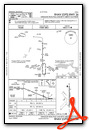
Instrument Approach Procedure (IAP) Charts
Nearby Airports with Instrument Procedures
| ID | Name | Heading / Distance | ||
|---|---|---|---|---|
 |
F10 | Henryetta Municipal Airport | 191° | 16.0 |
|
KRVS | Tulsa Riverside Airport | 355° | 22.3 |
|
3F7 | Jones Memorial Airport | 289° | 24.5 |
|
KMKO | Muskogee-Davis Regional Airport | 091° | 28.7 |
|
KTUL | Tulsa International Airport | 005° | 31.9 |
|
KOWP | William R Pogue Municipal Airport | 342° | 32.0 |
|
H68 | Hefner-Easley Airport | 058° | 34.6 |
|
O47 | Prague Municipal Airport | 253° | 39.3 |
|
F99 | Holdenville Municipal Airport | 213° | 41.8 |
|
KCQB | Chandler Regional Airport | 274° | 42.7 |
|
KSRE | Seminole Municipal Airport | 236° | 42.7 |
|
KCUH | Cushing Municipal Airport | 293° | 43.7 |
Airport Images

By: alswineford


