Login
Register


OWP
William R Pogue Municipal Airport
Official FAA Data Effective 2026-01-22 0901Z
Chart Supplement

VFR Chart of KOWP
Sectional Charts at SkyVector.com
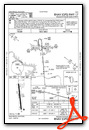
IFR Chart of KOWP
Enroute Charts at SkyVector.com
Location Information for KOWP
Coordinates: N36°10.52' / W96°9.11'Located 03 miles NW of Sand Springs, Oklahoma on 464 acres of land. View all Airports in Oklahoma.
Surveyed Elevation is 892 feet MSL.
Operations Data
|
|
Airport Communications
| AWOS-3T: | 118.325 Tel. 918-246-2635 |
|---|---|
| TULSA APPROACH: | 124.0 338.3 |
| TULSA DEPARTURE: | 124.0 338.3 |
| UNICOM: | 122.700 |
| CTAF: | 122.700 |
| ASOS at RVS (11.2 SE): | 126.5 918-299-0740 |
| ATIS at RVS (11.5 SE): | 126.5 |
| D-ATIS at TUL (12.9 E): | 124.9 |
Nearby Navigation Aids
|
| ||||||||||||||||||||||||||||||||||||||||||||||||||||||||||||


Runway 17/35
| Dimensions: | 5799 x 100 feet / 1768 x 30 meters | |
|---|---|---|
| Surface: | Asphalt in Good Condition | |
| Weight Limits: | S-30, D-58 | |
| Edge Lighting: | Medium Intensity | |
| Runway 17 | Runway 35 | |
| Coordinates: | N36°10.99' / W96°9.16' | N36°10.04' / W96°9.06' |
| Elevation: | 889.0 | 890.1 |
| Traffic Pattern: | Left RIGHT TFC FOR HELIS. |
Left |
| Runway Heading: | 175° True | 355° True |
| Markings: | Non-Precision Instrument in good condition. | Non-Precision Instrument in good condition. |
| Glide Slope Indicator | P4L (3.00° Glide Path Angle) | P4L (3.00° Glide Path Angle) PAPI UNUSBL BYD 8 DEGS LEFT, RIGHT OF RCL. |
| Approach Lights: | ODALS Omnidirectional Approach Lighting System | |
| Obstacles: | 14 ft Trees 566 ft from runway, 264 ft left of center | |
Services Available
| Fuel: | 100LL (blue) |
|---|---|
| Transient Storage: | Tiedowns |
| Airframe Repair: | MAJOR |
| Engine Repair: | MAJOR |
| Bottled Oxygen: | NONE |
| Bulk Oxygen: | NONE |
| Other Services: | PILOT INSTRUCTION,AIRCRAFT RENTAL |
Ownership Information
| Ownership: | Publicly owned | |
|---|---|---|
| Owner: | CITY OF SAND SPRINGS | |
| CITY HALL, 100 E. BROADWAY | ||
| SAND SPRINGS, OK 74063 | ||
| 918-246-2500 | ||
| Manager: | KEN MADISON | |
| 3200 N AIRPORT RD | ||
| SAND SPRINGS, OK 74063 | ||
| 918-246-2605 | AFT HRS OR EMER: 918-638-6895. | |
Other Remarks
- DEER INVOF ARPT.
- HELICOPTER TRNG WEST TWY & WEST RAMP.
- FOR CD CTC TULSA APCH AT 918-831-6714/6720.
- 0LL FUEL AVBL 24 HRS WITH MAJOR CREDIT CARD.
- ACTVT ODALS RWY 35; MIRL RWY 17/35 - CTAF. PAPI RWY 17 & 35 ON CONSLY.
Weather Minimums

Instrument Approach Procedure (IAP) Charts
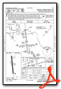
Nearby Airports with Instrument Procedures
| ID | Name | Heading / Distance | ||
|---|---|---|---|---|
 |
KRVS | Tulsa Riverside Airport | 134° | 11.5 |
|
KTUL | Tulsa International Airport | 083° | 12.9 |
|
3F7 | Jones Memorial Airport | 210° | 25.7 |
|
KOKM | Okmulgee Regional/Paul and Betty Abbott Field Airport | 161° | 32.0 |
|
KCUH | Cushing Municipal Airport | 246° | 33.1 |
|
KGCM | Claremore Regional Airport | 077° | 33.4 |
|
KBVO | Bartlesville Municipal Airport | 010° | 35.9 |
|
H71 | Mid-America Industrial Airport | 085° | 40.0 |
|
H68 | Hefner-Easley Airport | 107° | 41.4 |
|
KCQB | Chandler Regional Airport | 230° | 42.3 |
|
KSWO | Stillwater Regional Airport | 269° | 45.4 |
|
F10 | Henryetta Municipal Airport | 171° | 46.5 |
Airport Images
")
By: klmadison@sands...
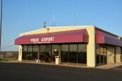
By: Devangi patel
- 1 of 4
- next ›


Comments
I believe the published fuel
I believe the published fuel price is for a purchase of 50 gallons or more. If less the price is a little higher. Excellent place to stop. Friendly and helpful with fueling. Snacks available. Always my choice of stops between Lincoln and Houston.
Pages