Login
Register


RVS
Tulsa Riverside Airport
Official FAA Data Effective 2026-01-22 0901Z
From the Flight Deck
Chart Supplement

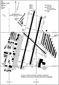
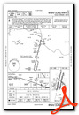
KRVS Airport Diagram
VFR Chart of KRVS
Sectional Charts at SkyVector.com
IFR Chart of KRVS
Enroute Charts at SkyVector.com
Location Information for KRVS
Coordinates: N36°2.38' / W95°59.08'Located 05 miles S of Tulsa, Oklahoma on 664 acres of land. View all Airports in Oklahoma.
Surveyed Elevation is 638 feet MSL.
Operations Data
|
|
Airport Communications
| ATIS: | 126.5 |
|---|---|
| ASOS: | 126.5 Tel. 918-299-0740 |
| RIVERSIDE TOWER: | 119.2 120.3 |
| RIVERSIDE GROUND: | 121.7 |
| TULSA APPROACH: | 119.85 ;356-174 134.7 ;175-355 |
| TULSA DEPARTURE: | 119.85 ;356-174 134.7 ;175-355 |
| IC: | 134.7 ;175-355 |
| CLEARANCE DELIVERY: | 124.5 |
| PRE TAXI CLNC: | 124.5 |
| UNICOM: | 122.950 |
| VINTA STAR: | 119.1 360.825 |
| CTAF: | 120.300 |
| TULSA DP: | 124.0 338.3 |
| D-ATIS at TUL (10.6 NE): | 124.9 |
| ASOS at TUL (10.8 NE): | 539-399-0187 |
| AWOS-3T at OWP (11.5 NW): | 118.325 918-246-2635 |
- ONLY USE 119.2 LCL/TWR FREQUENCY WHEN ADVISED TO DO SO BY RVS ATC OR WHEN BROADCASTED ON RVS ATIS.
- USE AS PRI LCL/TWR FREQ ONLY WHEN ADZD BY ATIS OR ATC.
Nearby Navigation Aids
|
| ||||||||||||||||||||||||||||||||||||||||||||||||||||||||||||


Runway 01L/19R
| Dimensions: | 5101 x 100 feet / 1555 x 30 meters | |
|---|---|---|
| Surface: | Asphalt / Grooved in Good Condition ONLY CNTR 80 FT GRVD. | |
| Weight Limits: | 27 /F/B/X/T, S-61, D-87, ST-168 | |
| Edge Lighting: | High Intensity | |
| Runway 01L | Runway 19R | |
| Coordinates: | N36°1.98' / W95°59.27' | N36°2.80' / W95°59.03' |
| Elevation: | 621.9 | 638.2 |
| Traffic Pattern: | Right | |
| Runway Heading: | 13° True | 193° True |
| Markings: | Precision Instrument in good condition. | Non-Precision Instrument in good condition. |
| Glide Slope Indicator | P4L (3.00° Glide Path Angle) | P4L (3.20° Glide Path Angle) |
| REIL: | Yes | Yes |
| Obstacles: | 31 ft Trees 1450 ft from runway | 36 ft Trees 1076 ft from runway, 151 ft left of center |
Runway 01R/19L
| Dimensions: | 4205 x 100 feet / 1282 x 30 meters | |
|---|---|---|
| Surface: | Asphalt in Good Condition | |
| Weight Limits: | S-30, D-60 | |
| Edge Lighting: | Medium Intensity | |
| Runway 01R | Runway 19L | |
| Coordinates: | N36°2.04' / W95°59.11' | N36°2.72' / W95°58.91' |
| Elevation: | 619.2 | 630.2 |
| Traffic Pattern: | Right | |
| Runway Heading: | 13° True | 193° True |
| Displaced Threshold: | 142 Feet | |
| Markings: | Basic in good condition. | Basic in good condition. |
| Glide Slope Indicator | P4L (2.83° Glide Path Angle) | P4L (2.83° Glide Path Angle) |
| Obstacles: | 48 FT PLINE 826 FT FM RWY 19L END CREATES 20:1 APCH CLNC SLP TO DTHR. |
48 ft Power Line 826 ft from runway 8 FT ROAD 200 FT FM RWY THR, BOTH SIDES. |
Runway 13/31
| Dimensions: | 2639 x 50 feet / 804 x 15 meters | |
|---|---|---|
| Surface: | Asphalt in Fair Condition | |
| Weight Limits: | S-30 | |
| Edge Lighting: | Medium Intensity | |
| Runway 13 | Runway 31 | |
| Coordinates: | N36°2.49' / W95°59.23' | N36°2.19' / W95°58.84' |
| Elevation: | 624.4 | 614.8 |
| Traffic Pattern: | Right | |
| Runway Heading: | 133° True | 313° True |
| Markings: | Basic in good condition. | Basic in good condition. |
| Obstacles: | 71 ft Trees 1329 ft from runway | |
Services Available
| Fuel: | 100LL (blue), Jet-A, Jet A+ |
|---|---|
| Transient Storage: | Hangars,Tiedowns |
| Airframe Repair: | MAJOR |
| Engine Repair: | MAJOR |
| Bottled Oxygen: | LOW |
| Bulk Oxygen: | NOT AVAILABLE |
| Other Services: | AIR AMBULANCE SERVICES,AVIONICS,CHARTER SERVICE,PILOT INSTRUCTION,AIRCRAFT RENTAL,AIRCRAFT SALES |
Ownership Information
| Ownership: | Publicly owned | |
|---|---|---|
| Owner: | CITY OF TULSA | |
| TULSA ARPT IMPROVEMENT TRUST | ||
| BOX 581838 TULSA, OK 74158 | ||
| 918-838-5000 | ||
| Manager: | AUSTIN WHEELER | |
| 8303 S. HANGAR RD. | ||
| TULSA, OK 74132 | ||
| 918-299-5886 | ||
Other Remarks
- NE, NW & SW RAMPS, PTNS OF TXL CC, DD & GG NOT VSB FM ATCT.
- NOISE ABATEMENT: TURNS ON DEP PRIOR TO 1500 FT MSL NA.
- BIRDS ON & INVOF ARPT.
- TXL BB & NW PVT HNGR AREA TXL 20 FT WIDE.
- NE & NW PVT HNGR AREA WINGSPAN GTR THAN 49 FT NA; TXL WT LMT 12500 LB.
- L TURN ON DEP BFR 1500 FT MSL NA.
- MNTN TPA UNTIL ABEAM AER ON DOWNWIND LEG.
- WHEN ATCT CLSD ACTVT MIRL RWY 01R/19L & 13/31; HIRL RWY 01L/19R; TWY H, L, T & Z; TXL DD - CTAF. HIRL RWY 01L/19R PRESET MED INTST; INCR INTST - CTAF.
Weather Minimums

Standard Terminal Arrival (STAR) Charts
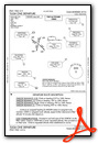
Instrument Approach Procedure (IAP) Charts


Departure Procedure (DP) Charts
Nearby Airports with Instrument Procedures
| ID | Name | Heading / Distance | ||
|---|---|---|---|---|
 |
KTUL | Tulsa International Airport | 026° | 10.6 |
|
KOWP | William R Pogue Municipal Airport | 315° | 11.5 |
|
KOKM | Okmulgee Regional/Paul and Betty Abbott Field Airport | 175° | 22.3 |
|
3F7 | Jones Memorial Airport | 236° | 25.4 |
|
KGCM | Claremore Regional Airport | 058° | 28.8 |
|
H68 | Hefner-Easley Airport | 097° | 31.6 |
|
H71 | Mid-America Industrial Airport | 070° | 33.7 |
|
KMKO | Muskogee-Davis Regional Airport | 126° | 38.0 |
|
F10 | Henryetta Municipal Airport | 182° | 37.9 |
|
KCUH | Cushing Municipal Airport | 262° | 38.8 |
|
KBVO | Bartlesville Municipal Airport | 358° | 43.4 |
|
KCQB | Chandler Regional Airport | 245° | 44.9 |
Fuel Providers

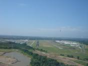
Airport Images

By: MATEO
By: MATEO


