Login
Register


GCM
Claremore Regional Airport
Official FAA Data Effective 2026-02-19 0901Z
Chart Supplement

VFR Chart of KGCM
Sectional Charts at SkyVector.com
IFR Chart of KGCM
Enroute Charts at SkyVector.com
Location Information for KGCM
Coordinates: N36°17.56' / W95°28.78'Located 07 miles E of Claremore, Oklahoma on 566 acres of land. View all Airports in Oklahoma.
Surveyed Elevation is 733 feet MSL.
Operations Data
|
|
Airport Communications
| AWOS-3PT: | 119.925 Tel. 918-343-0184 |
|---|---|
| TULSA APPROACH: | 119.1 360.825 |
| TULSA DEPARTURE: | 119.1 360.825 |
| UNICOM: | 122.700 |
| CTAF: | 122.700 |
| AWOS-3PT at H71 (8.3 SE): | 120.1 918-476-0517 |
| ASOS at TUL (20.1 W): | 539-399-0187 |
| D-ATIS at TUL (20.6 W): | 124.9 |
Nearby Navigation Aids
|
| ||||||||||||||||||||||||||||||||||||||||||||||||||||||||||||


Runway 18/36
| Dimensions: | 5200 x 75 feet / 1585 x 23 meters | |
|---|---|---|
| Surface: | Asphalt in Good Condition | |
| Weight Limits: | S-30, D-58, ST-119 | |
| Edge Lighting: | Medium Intensity | |
| Runway 18 | Runway 36 | |
| Coordinates: | N36°17.99' / W95°28.78' | N36°17.13' / W95°28.78' |
| Elevation: | 697.0 | 733.0 |
| Runway Heading: | 180° True | 360° True |
| Markings: | Non-Precision Instrument in good condition. | Non-Precision Instrument in good condition. |
| Glide Slope Indicator | P4L (3.00° Glide Path Angle) | P4L (3.00° Glide Path Angle) |
| Approach Lights: | ODALS Omnidirectional Approach Lighting System | |
| REIL: | Yes | |
| Obstacles: | 19 ft Trees 615 ft from runway, 151 ft left of center | 15 ft Trees 633 ft from runway |
Services Available
| Fuel: | 100LL (blue), Jet-A |
|---|---|
| Transient Storage: | Hangars,Tiedowns |
| Airframe Repair: | MAJOR |
| Engine Repair: | MAJOR |
| Bottled Oxygen: | NONE |
| Bulk Oxygen: | NONE |
| Other Services: | AIR AMBULANCE SERVICES,PILOT INSTRUCTION,AIRCRAFT RENTAL |
Ownership Information
| Ownership: | Publicly owned | |
|---|---|---|
| Owner: | CITY OF CLAREMORE | |
| PO BOX 249 | ||
| CLAREMORE, OK 74018 | ||
| 918-341-2365 | ||
| Manager: | COLBY LINDER | |
| 19502 E. ROGERS POST ROAD | ||
| CLAREMORE, OK 74019 | ||
| 918-343-0931 | ||
Other Remarks
- FOR CD CTC TULSA APCH AT 918-831-6714/6720.
- 0LL 24 HR AUTO FUEL SVC SYS FOR 100LL & JET A.
- ACTVT ODALS RWY 18; REIL RWY 36 - CTAF. MIRL RWY 18/36 SS-SR. PAPI RWY 18 AND 36 ON CONSLY.
Weather Minimums

Instrument Approach Procedure (IAP) Charts


Nearby Airports with Instrument Procedures
| ID | Name | Heading / Distance | ||
|---|---|---|---|---|
 |
H71 | Mid-America Industrial Airport | 119° | 8.3 |
|
KTUL | Tulsa International Airport | 254° | 20.6 |
|
H68 | Hefner-Easley Airport | 161° | 20.7 |
|
H04 | Vinita Municipal Airport | 039° | 25.0 |
|
1K8 | South Grand Lake Regional Airport | 055° | 27.2 |
|
KRVS | Tulsa Riverside Airport | 238° | 28.8 |
|
KTQH | Tahlequah Municipal Airport | 133° | 31.7 |
|
KOWP | William R Pogue Municipal Airport | 258° | 33.4 |
|
KBVO | Bartlesville Municipal Airport | 317° | 38.2 |
|
KMKO | Muskogee-Davis Regional Airport | 171° | 38.5 |
|
KGMJ | Grove Regional Airport | 062° | 40.5 |
|
KOKM | Okmulgee Regional/Paul and Betty Abbott Field Airport | 211° | 43.8 |
Fuel Providers

Airport Images
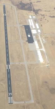
By: KBurkhardt
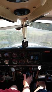
By: shyflyguy


