Login
Register


SLQ
Sleetmute Airport
Official FAA Data Effective 2025-12-25 0901Z
Chart Supplement

VFR Chart of PASL
Sectional Charts at SkyVector.com
IFR Chart of PASL
Enroute Charts at SkyVector.com
Location Information for PASL
Coordinates: N61°42.03' / W157°9.95'Located 00 miles E of Sleetmute, Alaska on 145 acres of land. View all Airports in Alaska.
Surveyed Elevation is 191 feet MSL.
Operations Data
|
|
Airport Communications
| AWOS-3P: | 134.85 Tel. 907-449-4226 |
|---|---|
| UNICOM: | 122.800 |
| CTAF: | 122.800 |
| AWOS-3PT at CJX (29.3 W): | 118.4 907-269-2726 |
| AWOS-3 at SVW (58.3 SE): | 907-731-9001 |
- APCH/DEP CTL SVC PRVVD ANCHORAGE ARTCC (ZAN) ON 128.5/379.9 (SPARREVOHN RCAG).
Nearby Navigation Aids
|
| ||||||||||||||||||||||||


Runway 15/33
| Dimensions: | 3100 x 60 feet / 945 x 18 meters | |
|---|---|---|
| Surface: | Gravel in Fair Condition N 500 FT SOFT; RMNDR SOFT SPOTS. | |
| Edge Lighting: | Medium Intensity | |
| Runway 15 | Runway 33 | |
| Coordinates: | N61°42.28' / W157°10.08' | N61°41.78' / W157°9.82' |
| Elevation: | 190.9 | 191.3 |
| Traffic Pattern: | Left | Left |
| Runway Heading: | 166° True | 346° True |
| Markings: | Non-Standard in fair condition. | Non-Standard in fair condition. |
| Obstacles: | 12 ft Brush 0 ft from runway | 28 ft Tree 0 ft from runway |
Services Available
| Fuel: | 100LL (blue) |
|---|---|
| Transient Storage: | NONE |
| Airframe Repair: | NOT AVAILABLE |
| Engine Repair: | NOT AVAILABLE |
| Bottled Oxygen: | NOT AVAILABLE |
| Bulk Oxygen: | NOT AVAILABLE |
Ownership Information
| Ownership: | Publicly owned | |
|---|---|---|
| Owner: | ALASKA DOT&PF CENTRAL REGION | |
| PO BOX 196900 | ||
| ANCHORAGE, AK 99519-6900 | ||
| 907-269-0749 | ||
| Manager: | KEN SMITH | |
| PO BOX 196900 | ||
| ANCHORAGE, AK 99519-7300 | ||
| 907-676-0505 | ||
Other Remarks
- RWY COND UNMNT; RCMD VISUAL INSP BFR USE.
- ATVS ON OR INVOF RWY.
- RED DEVIL ARPT 8 MI NW.
- WX CAMERA AVBL ON INTERNET AT HTTPS://WEATHERCAMS.FAA.GOV.
- COLD TEMPERATURE AIRPORT. ALTITUDE CORRECTION REQUIRED AT OR BELOW -36C.
- END LGTS.
- END LGTS.
- 0LL AVBL - CTAF OR 907-449-4227.
- ACTVT MIRL RWY 15/33 - CTAF.
Weather Minimums

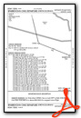
Instrument Approach Procedure (IAP) Charts
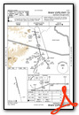
Departure Procedure Obstacles (DPO) Charts
Nearby Airports with Instrument Procedures
| ID | Name | Heading / Distance | ||
|---|---|---|---|---|
 |
PACJ | Crooked Creek Airport | 290° | 29.5 |
|
PACH | Chuathbaluk Airport | 263° | 59.1 |
|
PANI | Aniak Airport | 265° | 68.5 |
|
PAHC | Holy Cross Airport | 292° | 79.6 |
|
PAMC | Mc Grath Airport | 029° | 87.1 |
|
PAHX | Shageluk Airport | 312° | 90.1 |
|
PAGX | Grayling Airport | 312° | 108.4 |
|
PAFS | Nikolai Airport | 043° | 111.6 |
|
PAJZ | Koliganek Airport | 181° | 118.8 |
|
PAKX | Wilder Runway Airport | 136° | 122.8 |
|
PANO | Nondalton Airport | 145° | 124.0 |
|
PAIL | Iliamna Airport | 149° | 134.4 |
Airport Images
Do you have a recent image of this airport? Upload it here!


