Login
Register


SUA
Witham Field Airport
Official FAA Data Effective 2026-02-19 0901Z
Chart Supplement

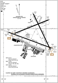
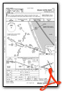
KSUA Airport Diagram
VFR Chart of KSUA
Sectional Charts at SkyVector.com
IFR Chart of KSUA
Enroute Charts at SkyVector.com
Location Information for KSUA
Coordinates: N27°10.90' / W80°13.28'Located 01 miles SE of Stuart, Florida on 726 acres of land. View all Airports in Florida.
Surveyed Elevation is 16 feet MSL.
Operations Data
|
|
Airport Communications
| ATIS: | 134.475 |
|---|---|
| AWOS-3: | 134.475 Tel. 772-692-7399 |
| STUART TOWER: | 126.6 |
| STUART GROUND: | 121.7 |
| PALM BEACH APPROACH: | 132.8 ;SOUTH |
| PALM BEACH DEPARTURE: | 132.8 ;SOUTH |
| CLEARANCE DELIVERY: | 121.025 |
| EMERG: | 121.5 243.0 |
| SNDLR DP: | 123.625 |
| VUUDU STAR: | 127.35 317.4 |
| TTYLR STAR: | 125.2 317.4 |
| BRNGR DP: | 123.625 |
| CTAF: | 126.600 |
| AWOS-3 at F45 (20.2 S): | 119.975 561-630-6932 |
| ATIS at FPR (20.6 NW): | 134.825 |
| ASOS at FPR (20.7 NW): | 772-489-4281 |
- ATCT OWNED/OPERATED BT GRUMMAN AEROSPACE CORP.
Nearby Navigation Aids
|
| ||||||||||||||||||||||||||||||||||||||||||||||||||||||


Runway 12/30
ARRESTING GEAR/SYSTEM: ENGINEERED MATERIALS ARRESTING SYSTEM (EMAS) 502 FT IN LENGTH BY 109 FT IN WIDTH AT THE DEPARTURE END OF RWY 12. ARRESTING GEAR/SYSTEM: ENGINEERED MATERIALS ARRESTING SYSTEM (EMAS) 413 FT IN LENGTH BY 109 FT IN WIDTH AT THE DEPARTURE END OF RWY 30. | ||
| Dimensions: | 5828 x 100 feet / 1776 x 30 meters | |
|---|---|---|
| Surface: | Asphalt / Grooved in Good Condition | |
| Weight Limits: | 27 /F/B/W/T, S-65, D-105, ST-190 | |
| Edge Lighting: | Medium Intensity | |
| Runway 12 | Runway 30 | |
| Coordinates: | N27°10.93' / W80°13.88' | N27°10.59' / W80°12.88' |
| Elevation: | 14.7 | 11.4 |
| Traffic Pattern: | Left | Left |
| Runway Heading: | 110° True | 290° True |
| Displaced Threshold: | 460 Feet | |
| Declared Distances: | TORA:5828 TODA:5828 ASDA:5828 LDA:5368 | TORA:5828 TODA:5828 ASDA:5828 LDA:5828 |
| Markings: | Non-Precision Instrument in good condition. | Non-Precision Instrument in good condition. |
| Glide Slope Indicator | P4L (3.00° Glide Path Angle) | P4L (3.00° Glide Path Angle) |
| REIL: | Yes | Yes |
| Obstacles: | 34 ft Trees 690 ft from runway, 260 ft left of center RWY 12 APCH SLP 34:1 TO DSPLCD THLD. |
52 ft Tree 1745 ft from runway, 205 ft left of center RWY 30 APCH SLP 34:1 TO AER. |
Runway 16/34
| Dimensions: | 5000 x 100 feet / 1524 x 30 meters | |
|---|---|---|
| Surface: | Asphalt / Grooved in Good Condition | |
| Weight Limits: | 30 /F/B/X/T, S-55, D-90, ST-160 | |
| Runway 16 | Runway 34 | |
| Coordinates: | N27°11.31' / W80°13.30' | N27°10.57' / W80°12.90' |
| Elevation: | 11.9 | 11.7 |
| Traffic Pattern: | Left | Left |
| Runway Heading: | 154° True | 334° True |
| Displaced Threshold: | 336 Feet | 900 Feet |
| Declared Distances: | TORA:5000 TODA:5000 ASDA:4800 LDA:4464 | TORA:5000 TODA:5000 ASDA:5000 LDA:4100 |
| Markings: | Basic in fair condition. | Basic in fair condition. |
| Obstacles: | 47 ft Trees 1055 ft from runway, 260 ft left of center RWY 16 APCH SLP 30:1 TO DSPLCD THLD. |
22 ft Trees 200 ft from runway, 150 ft left of center RWY 34 APCH RATIO 35:1 TO DSPLCD THLD. RWY 34 HAS 22 FT TREES AND 8 FT FENCE 200 FT FROM THE RWY END AND 150 FT LEFT. |
Runway 07/25
| Dimensions: | 4653 x 100 feet / 1418 x 30 meters | |
|---|---|---|
| Surface: | Asphalt / Grooved in Fair Condition | |
| Weight Limits: | 14 /F/B/X/T, S-58, D-95, ST-170 | |
| Edge Lighting: | Medium Intensity | |
| Runway 07 | Runway 25 | |
| Coordinates: | N27°10.90' / W80°13.74' | N27°11.18' / W80°12.94' |
| Elevation: | 15.4 | 9.9 |
| Traffic Pattern: | Left | Left |
| Runway Heading: | 68° True | 248° True |
| Markings: | Non-Precision Instrument in fair condition. | Non-Precision Instrument in fair condition. |
| Glide Slope Indicator | P4L (3.00° Glide Path Angle) | P4L (3.00° Glide Path Angle) |
| Obstacles: | 61 ft Tower 2052 ft from runway, 75 ft left of center | 49 ft Tree 1355 ft from runway, 290 ft left of center |
Services Available
| Fuel: | 100LL (blue), Jet-A |
|---|---|
| Transient Storage: | Hangars,Tiedowns |
| Airframe Repair: | MAJOR |
| Engine Repair: | MAJOR |
| Bottled Oxygen: | NONE |
| Bulk Oxygen: | NONE |
| Other Services: | AIR AMBULANCE SERVICES,AVIONICS,CHARTER SERVICE,PILOT INSTRUCTION,AIRCRAFT RENTAL,AIRCRAFT SALES |
Ownership Information
| Ownership: | Publicly owned | |
|---|---|---|
| Owner: | MARTIN COUNTY | |
| 2401 SE MONTEREY RD | ||
| STUART, FL 34996 | ||
| 772-221-2374 | ||
| Manager: | ANDREW MCBEAN | |
| 2011 SOUTHEAST AIRPORT ROAD | ||
| STUART, FL 34996 | ||
| 772-221-1458 | ||
Other Remarks
- ACFT WITH WING SPANS EXCEEDING 79 FT ARE PROHIBITED FROM OPERATING ON TWY 'A' BETWEEN TWY 'C' AND APCH END RY 12 WHEN ACFT WITH WING SPAN EXCEEDING 79 FT IS ON APCH TO, LNDG, OR TAKING OFF RY 12/30.
- BIRDS ON & INVOF ARPT.
- PAPI RESTRICTED TO 7.5 NM WEST OF RWY 25 DUE TO 1548' MSL TOWERS WITHIN 10 DEG OF EXT CNTLN.
- WHEN ATCT CLSD, FOR CD CTC PALM BEACH APCH AT 561-684-9047.
- NOISE SENSITIVE AREAS ALL QUADRANTS. NOISE ABATEMENT PROCEDURES IN EFFECT CALL AMGR 772-221-2374.
- TOUCH & GO OPNS PERMITTED MON-SAT (EXCP NEW YEARS, CHRISTMAS & THANKSGIVING) 0900 UNTIL 2 HRS PAST SS AND ARE LIMITED TO 3 OPNS PER PILOT PER DAY.
- STOP & GO OPNS AND INTXN TKOFS STRONGLY DISCOURAGED AT ALL TIMES.
- STAGE 1 & 2 JET OPNS STRONGLY DISCOURAGED 2300-0800.
- PPR FOR ACFT EXCEEDING RY WT CPTY.
- AFTER 2200 ACTVT REIL RWY 12 & 30; MIRL RWY 07/25 & 12/30- CTAF.
Weather Minimums

Standard Terminal Arrival (STAR) Charts


Instrument Approach Procedure (IAP) Charts

Departure Procedure (DP) Charts


Nearby Airports with Instrument Procedures
| ID | Name | Heading / Distance | ||
|---|---|---|---|---|
 |
06FA | William P Gwinn Airport | 199° | 17.3 |
|
F45 | North Palm Beach County General Aviation Airport | 180° | 20.1 |
|
KFPR | Treasure Coast International Airport | 336° | 20.6 |
|
KVRB | Vero Beach Regional Airport | 339° | 30.2 |
|
KPBI | Palm Beach International Airport | 167° | 30.6 |
|
KOBE | Okeechobee County Airport | 278° | 34.0 |
|
KPHK | Palm Beach County Glades Airport | 226° | 34.7 |
|
KLNA | Palm Beach County Park Airport | 168° | 36.0 |
|
X26 | Sebastian Municipal Airport | 338° | 40.5 |
|
KBCT | Boca Raton Airport | 172° | 48.4 |
|
X59 | Valkaria Airport | 338° | 50.0 |
|
2IS | Airglades Airport | 239° | 51.9 |
Airport Images
Do you have a recent image of this airport? Upload it here!


