Login
Register


PMZ
Plymouth Municipal Airport
Official FAA Data Effective 2026-02-19 0901Z
Chart Supplement

VFR Chart of KPMZ
Sectional Charts at SkyVector.com
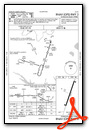
IFR Chart of KPMZ
Enroute Charts at SkyVector.com
Location Information for KPMZ
Coordinates: N35°48.65' / W76°45.50'Located 02 miles S of Plymouth, North Carolina on 390 acres of land. View all Airports in North Carolina.
Surveyed Elevation is 36 feet MSL.
Operations Data
|
|
Airport Communications
| CHERRY POINT APPROACH: | 119.35 377.175 |
|---|---|
| CHERRY POINT DEPARTURE: | 119.35 377.175 |
| CTAF: | 122.800 |
| UNICOM: | 122.800 |
| AWOS-3 at EDE (16.1 NE): | 118.275 252-482-0757 |
| AWOS-3 at OCW (20.3 SW): | 120.175 252-975-6133 |
| AWOS-3P at MCZ (20.5 W): | 118.65 252-802-4261 |
Nearby Navigation Aids
|
| ||||||||||||||||||||||||||||||||||||||||||||||||||||||||||||


Runway 03/21
| Dimensions: | 5500 x 75 feet / 1676 x 23 meters | |
|---|---|---|
| Surface: | Asphalt in Good Condition | |
| Weight Limits: | S-30, D-40 | |
| Edge Lighting: | Medium Intensity | |
| Runway 03 | Runway 21 | |
| Coordinates: | N35°48.21' / W76°45.67' | N35°49.08' / W76°45.34' |
| Elevation: | 36.3 | 34.9 |
| Traffic Pattern: | Left | Left |
| Runway Heading: | 17° True | 197° True |
| Markings: | Non-Precision Instrument in good condition. | Non-Precision Instrument in good condition. |
| Glide Slope Indicator | P2L (4.00° Glide Path Angle) | P2L (4.00° Glide Path Angle) |
| REIL: | Yes | Yes |
| Obstacles: | 43 ft Trees 514 ft from runway, 256 ft left of center | 32 ft Trees 1257 ft from runway, 26 ft left of center |
Services Available
| Fuel: | 100LL (blue), Jet A-1+ |
|---|---|
| Transient Storage: | Tiedowns |
| Airframe Repair: | NONE |
| Engine Repair: | NONE |
| Bottled Oxygen: | NONE |
| Bulk Oxygen: | NONE |
| Other Services: | CROP DUSTING SERVICES,PILOT INSTRUCTION,AIRCRAFT RENTAL |
Ownership Information
| Ownership: | Publicly owned | |
|---|---|---|
| Owner: | WASHINGTON COUNTY | |
| PO BOX 1007, 116 ADAMS STREET | ||
| PLYMOUTH, NC 27962 | ||
| 252-793-5823 | ||
| Manager: | MARY MQSCATO | |
| 1069 AIRPORT RD. | ||
| PLYMOUTH, NC 27962 | ||
| 252-793-9801 | ||
Other Remarks
- CTN: ARPT LCTD 5 MI WEST OF MIL RSTRD AREA; HI PER MIL ACFT XNG ARPT BLW 3000 FT MSL ENRT TO RSTRD AREA - XNGS ARE UNANNCD.
- DEER ACT ON & INVOF ARPT.
- FOR CD CTC WASHINGTON ARTCC AT 703-771-3587.
- 0LL 24 HR SS FUELING WITH CC.
- ACTVT REIL RWY 03 & 21; PAPI RWY 03 & 21; MIRL RWY 03/21 - CTAF.
Weather Minimums

Instrument Approach Procedure (IAP) Charts

Nearby Airports with Instrument Procedures
| ID | Name | Heading / Distance | ||
|---|---|---|---|---|
 |
KEDE | Northeastern Regional Airport | 035° | 16.0 |
|
KOCW | Washington-Warren Airport | 224° | 20.3 |
|
KMCZ | Martin County Airport | 278° | 20.7 |
|
KPGV | Pitt-Greenville Airport | 251° | 32.3 |
|
KASJ | Tri-County At Henry Joyner Field Airport | 325° | 35.4 |
|
KETC | Tarboro-Edgecombe Airport | 281° | 39.2 |
|
KECG | Elizabeth City Cg Air Station/Regional Airport | 046° | 39.2 |
|
7W6 | Hyde County Airport | 110° | 42.0 |
|
KEWN | Coastal Carolina Regional Airport | 197° | 46.4 |
|
KONX | Currituck County Regional Airport | 045° | 50.5 |
|
KISO | Kinston Regional Jetport At Stallings Field Airport | 235° | 50.6 |
|
KMQI | Dare County Regional Airport | 082° | 52.2 |
Airport Images

By: gderego


Comments
Terminal is CLOSED on
Terminal is CLOSED on weekends, pilot lounge available but no services, no crew car. Sign on the door says 8-5 M-F ONLY