Login
Register


7W6
Hyde County Airport
Official FAA Data Effective 2026-02-19 0901Z
Chart Supplement

VFR Chart of 7W6
Sectional Charts at SkyVector.com
IFR Chart of 7W6
Enroute Charts at SkyVector.com
Location Information for 7W6
Coordinates: N35°33.73' / W75°57.37'Located 07 miles N of Engelhard, North Carolina on 387 acres of land. View all Airports in North Carolina.
Surveyed Elevation is 6 feet MSL.
Operations Data
|
|
Airport Communications
| AWOS-3P: | 119.275 Tel. 252-925-1136 |
|---|---|
| CHERRY POINT APPROACH: | 119.75 360.775 |
| CHERRY POINT DEPARTURE: | 119.75 360.775 |
| UNICOM: | 122.700 |
| CTAF: | 122.700 |
| AWOS-3 at MQI (24.8 NE): | 128.275 252-473-2826 |
| ASOS at HSE (25.7 SE): | 118.375 252-552-1005 |
| AWOS-3 at FFA (30.6 NE): | 118.075 252-449-0698 |
Nearby Navigation Aids
|
| ||||||||||||||||||||||||||||||||||||||||||||||||||||||||||||


Runway 11/29
| Dimensions: | 5002 x 100 feet / 1525 x 30 meters | |
|---|---|---|
| Surface: | Asphalt in Excellent Condition | |
| Weight Limits: | S-30, D-43 | |
| Edge Lighting: | Medium Intensity | |
| Runway 11 | Runway 29 | |
| Coordinates: | N35°33.80' / W75°57.87' | N35°33.65' / W75°56.87' |
| Elevation: | 6.5 | 6.6 |
| Traffic Pattern: | Right | Left |
| Runway Heading: | 100° True | 280° True |
| Markings: | Non-Precision Instrument in good condition. | Non-Precision Instrument in good condition. |
| Glide Slope Indicator | P2L (3.00° Glide Path Angle) | P2L (3.00° Glide Path Angle) |
| Obstacles: | 37 ft Trees 1415 ft from runway, 27 ft left of center | |
Services Available
| Fuel: | 100LL (blue) |
|---|---|
| Transient Storage: | Tiedowns |
| Airframe Repair: | NONE |
| Engine Repair: | NONE |
| Bottled Oxygen: | NONE |
| Bulk Oxygen: | NONE |
Ownership Information
| Ownership: | Publicly owned | |
|---|---|---|
| Owner: | HYDE COUNTY | |
| PO BOX 95 | ||
| SWAN QUARTER, NC 27885 | ||
| 252-473-3444 | ||
| Manager: | JOHNNY GIBBS | |
| PO BOX 189 | ||
| SWAN QUARTER, NC 27885 | ||
| 252-473-3444 | ||
Other Remarks
- R5314 5 MI NORTH OF ARPT AND R5313 5 MI EAST HAVE HVY CONCENTRATIONS OF MIL ACFT WI 1000 FT AGL AND IN EXCESS OF 500 KTS. MNVRNG FOR LDG AND AFT TKOF SHOULD RMN OVER LAND EAST OF ARPT.
- DEER & BIRDS ON & INVOF ARPT.
- GEESE NESTING NORTH SIDE OF RWY AT UPPER AND MIDDLE PONDS.
- FOR CD CTC WASHINGTON ARTCC AT 703-771-3587.
- 0LL 24 HR SELF SERVE WITH CREDIT CARD.
- ACTVT PAPI RWY 11 & 29; MIRL RWY 11/29 - CTAF.
Weather Minimums

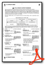
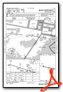
Instrument Approach Procedure (IAP) Charts
Nearby Airports with Instrument Procedures
| ID | Name | Heading / Distance | ||
|---|---|---|---|---|
 |
KMQI | Dare County Regional Airport | 030° | 24.9 |
|
KHSE | Billy Mitchell Airport | 139° | 25.8 |
|
W95 | Ocracoke Island Airport | 181° | 27.6 |
|
KFFA | First Flight Airport | 026° | 30.6 |
|
KEDE | Northeastern Regional Airport | 313° | 41.0 |
|
KPMZ | Plymouth Municipal Airport | 291° | 41.9 |
|
KECG | Elizabeth City Cg Air Station/Regional Airport | 345° | 43.2 |
|
KONX | Currituck County Regional Airport | 356° | 50.3 |
|
KOCW | Washington-Warren Airport | 270° | 53.5 |
|
KNKT | Cherry Point MCAS (Cunningham Field) Airport | 229° | 60.2 |
|
KMRH | Michael J Smith Field Airport | 215° | 60.5 |
|
KEWN | Coastal Carolina Regional Airport | 241° | 60.9 |
Airport Images
Do you have a recent image of this airport? Upload it here!


