Login
Register
SKX
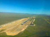
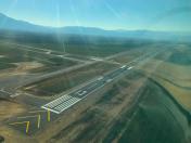
Taos Regional Airport
Official FAA Data Effective 2025-11-27 0901Z
VFR Chart of KSKX
Sectional Charts at SkyVector.com
IFR Chart of KSKX
Enroute Charts at SkyVector.com
Location Information for KSKX
Coordinates: N36°27.10' / W105°40.38'Located 08 miles NW of Taos, New Mexico on 832 acres of land. View all Airports in New Mexico.
Surveyed Elevation is 7094 feet MSL.
Operations Data
|
|
Airport Communications
| AWOS-3PT: | 132.975 Tel. 575-758-5663 |
|---|---|
| UNICOM: | 122.800 |
| CTAF: | 122.800 |
| AWOS-3 at AXX (18.6 E): | 118.025 575-377-0526 |
| AWOS-3PT at N24 (21.2 N): | 118.2 575-586-2019 |
| AWOS-3 at LAM (44.9 SW): | 124.175 505-662-8423 |
- COMMUNICATIONS PRVDD BY ALBUQUERQUE RADIO ON FREQS 122.1R/117.6T (TAOS RCO).
- APCH/DEP SVC PRVDD BY ALBUQUERQUE ARTCC (ZAB) 132.8/346.35 (CLINES CORNER RCAG).
Nearby Navigation Aids
|
| ||||||||||||||||||||||||||||||||||||
Runway 13/31
RWY 13: 150 FT BLAST PAD. RWY 31: 150 FT BLAST PAD. | ||
| Dimensions: | 8600 x 100 feet / 2621 x 30 meters | |
|---|---|---|
| Surface: | Concrete / Grooved in Good Condition | |
| Weight Limits: | 51 /F/D/X/T, S-60 | |
| Edge Lighting: | Medium Intensity | |
| Runway 13 | Runway 31 | |
| Coordinates: | N36°27.36' / W105°41.02' | N36°26.32' / W105°39.83' |
| Elevation: | 7047.3 | 7024.9 |
| Runway Heading: | 137° True | 317° True |
| Markings: | Precision Instrument in good condition. | Non-Precision Instrument in good condition. |
| Glide Slope Indicator | P4L (3.00° Glide Path Angle) | P4L (3.00° Glide Path Angle) |
| REIL: | Yes | Yes |
Runway 04/22
RWY 04: 150 FT BLAST PAD. RWY 22: 250 FT BLAST PAD. | ||
| Dimensions: | 5504 x 75 feet / 1678 x 23 meters | |
|---|---|---|
| Surface: | Asphalt / Porous Friction Course in Good Condition | |
| Weight Limits: | 4 /F/D/Y/T, S-24 | |
| Edge Lighting: | Medium Intensity | |
| Runway 04 | Runway 22 | |
| Coordinates: | N36°27.25' / W105°40.79' | N36°27.76' / W105°39.85' |
| Elevation: | 7052.4 | 7094.6 |
| Traffic Pattern: | Left | Left |
| Runway Heading: | 56° True | 236° True |
| Markings: | Non-Precision Instrument in good condition. | Basic in good condition. |
| Glide Slope Indicator | P4L (3.00° Glide Path Angle) | P4L (3.00° Glide Path Angle) |
| REIL: | Yes | |
Services Available
| Fuel: | 100LL (blue), Jet A-1+ |
|---|---|
| Transient Storage: | Hangars,Tiedowns |
| Airframe Repair: | MINOR |
| Engine Repair: | MINOR |
| Bottled Oxygen: | NOT AVAILABLE |
| Bulk Oxygen: | NOT AVAILABLE |
| Other Services: | AIR AMBULANCE SERVICES,PILOT INSTRUCTION |
Ownership Information
| Ownership: | Publicly owned | |
|---|---|---|
| Owner: | TOWN OF TAOS | |
| 400 CAMINO DE LA PLACITA | ||
| TAOS, NM 87571-6071 | ||
| 575-751-2000 | ||
| Manager: | COLTON RAPSTINE | |
| 24662 HIGHWAY 64 | PHYSICAL ADDRESS 24662 HWY 64, EL PRADO NM 87529 | |
| EL PRADO, NM 87529 | ||
| 575-770-1699 | EMER FONE: 575-770-1699 (CELL). | |
Other Remarks
- THIS AIRPORT HAS BEEN SURVEYED BY THE NATIONAL GEODETIC SURVEY.
- AVOID OVERFLIGHT OF TAOS PUEBLO WORLD HERITAGE SITE 5 NM EAST OF ARPT.
- RWY 04/22 PARALLEL TWY HAS RETRO-REFLECTORS.
- WILDLIFE INVOF ARPT.
- FOR CD IF UNA TO CTC ON FSS FREQ, CTC ALBUQUERQUE ARTCC AT 505-856-4561.
- 0LL FOR AFT HRS FUEL SVC CALL 575-758-5436. AFT HRS CALLOUT FEE CHARGED FOR JET A.
- ACTVT REIL RWY 04, 13, 31; PAPI RWY 04, 13, 22, 31; MIRL RWY 04/22, 13/31 - CTAF.
Weather Minimums
Instrument Approach Procedure (IAP) Charts
Nearby Airports with Instrument Procedures
| ID | Name | Heading / Distance | ||
|---|---|---|---|---|
 |
KAXX | Angel Fire Airport | 095° | 18.6 |
 |
KLAM | Los Alamos Airport | 220° | 44.9 |
 |
KSAF | Santa Fe Regional Airport | 202° | 54.0 |
 |
KLVS | Las Vegas Municipal Airport | 151° | 54.3 |
 |
KRTN | Raton Municipal/Crews Field Airport | 072° | 59.2 |
 |
KALS | San Luis Valley Regional/Bergman Field Airport | 351° | 59.7 |
 |
KMVI | Monte Vista Municipal Airport | 344° | 67.0 |
 |
KTAD | Perry Stokes Airport | 052° | 80.4 |
 |
KRCV | Astronaut Kent Rominger Airport | 336° | 82.4 |
 |
KPSO | Stevens Field Airport | 307° | 83.3 |
 |
4V1 | Spanish Peaks Airfield Airport | 029° | 85.9 |
 |
0E0 | Moriarty Municipal Airport | 190° | 89.7 |


