Login
Register


ALS
San Luis Valley Regional/Bergman Field Airport
Official FAA Data Effective 2026-01-22 0901Z
Chart Supplement

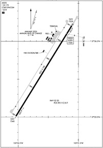
KALS Airport Diagram
VFR Chart of KALS
Sectional Charts at SkyVector.com
IFR Chart of KALS
Enroute Charts at SkyVector.com
Location Information for KALS
Coordinates: N37°26.11' / W105°52.07'Located 02 miles S of Alamosa, Colorado on 1700 acres of land. View all Airports in Colorado.
Surveyed Elevation is 7539 feet MSL.
Operations Data
|
|
Airport Communications
| ASOS: | 135.175 Tel. 719-589-5669 |
|---|---|
| UNICOM: | 122.800 |
| CTAF: | 122.800 |
| AWOS-3PT at RCV (28.4 NW): | 118.275 719-657-9017 |
| AWOS-3 at VTP (33.5 E): | 119.925 719-587-3120 |
| AWOS-3PT at N24 (40.3 S): | 118.2 575-586-2019 |
- APCH/DEP CTL SVC PRVDD BY DENVER ARTCC (ZDV) ON FREQS 128.375/379.95 (ALAMOSA RCAG).
Nearby Navigation Aids
|
| ||||||||||||||||||||||||||||||||||||

Runway 02/20
| Dimensions: | 8521 x 100 feet / 2597 x 30 meters | |
|---|---|---|
| Surface: | Asphalt / Grooved in Good Condition | |
| Edge Lighting: | High Intensity | |
| Runway 02 | Runway 20 | |
| Coordinates: | N37°25.51' / W105°52.54' | N37°26.70' / W105°51.61' |
| Elevation: | 7539.5 | 7539.3 |
| Traffic Pattern: | Left | Left |
| Runway Heading: | 32° True | 212° True |
| Declared Distances: | TORA:8519 TODA:8519 ASDA:8519 LDA:8519 | TORA:8519 TODA:8519 ASDA:8519 LDA:8519 |
| Markings: | Precision Instrument in fair condition. | Precision Instrument in fair condition. |
| Glide Slope Indicator | P4L (3.00° Glide Path Angle) | V4L (3.00° Glide Path Angle) |
| Approach Lights: | MALSR 1,400 Foot Medium-intensity Approach Lighting System with runway alignment indicator lights. | |
| REIL: | Yes | |
| Obstacles: | 40 ft Tree 1310 ft from runway, 15 ft right of center | |
Services Available
| Fuel: | 100LL (blue), Jet-A |
|---|---|
| Transient Storage: | Hangars,Tiedowns |
| Airframe Repair: | MAJOR |
| Engine Repair: | MAJOR |
| Bottled Oxygen: | HIGH/LOW |
| Bulk Oxygen: | HIGH/LOW |
| Other Services: | AIR FREIGHT SERVICES,CROP DUSTING SERVICES,AIR AMBULANCE SERVICES,AVIONICS,CARGO HANDLING SERVICES,CHARTER SERVICE,PILOT INSTRUCTION |
Ownership Information
| Ownership: | Publicly owned | |
|---|---|---|
| Owner: | CITY AND CO OF ALAMOSA | |
| 2490 STATE AVE | ||
| ALAMOSA, CO 81101 | ||
| 719-587-5211 | ||
| Manager: | SIRAH MASTERS | |
| 2490 STATE AVE | ||
| ALAMOSA, CO 81101 | ||
| 719-587-5211 | ||
Other Remarks
- APRON GA RAMP CLSD TO ACRS.
- CONDS UNMON AT NGT AFT LAST ACR ARR TIL 0600; SEE NOTAMS FOR CONDS.
- FOR CD CTC DENVER ARTCC ON FREQ. IF UNA, CTC FSS ON FREQ VIA RCO. IF UNA, CTC DENVER ARTCC AT 303-651-4257.
- PPR FOR UNSKED AIR CARRIER OPNS CALL ARPT OPS 719-588-4881 OR 719-588-4871.
- ARFF COVERAGE PROVDD DURG ACR OPS; OTR TIMES 24 HR PPR - ARPT OPS 719-588-4881/4871.
- HOP ON & INVOF ARPT.
- COLD TEMPERATURE AIRPORT. ALTITUDE CORRECTION REQUIRED AT OR BELOW -25C.
- ACTVT MALSR RWY 02; REIL RWY 20; VASI RWY 20; HIRL RWY 02/20 - CTAF 122.8
Weather Minimums

Instrument Approach Procedure (IAP) Charts

Nearby Airports with Instrument Procedures
| ID | Name | Heading / Distance | ||
|---|---|---|---|---|
 |
KMVI | Monte Vista Municipal Airport | 303° | 10.2 |
|
KRCV | Astronaut Kent Rominger Airport | 306° | 28.5 |
|
4V1 | Spanish Peaks Airfield Airport | 072° | 54.0 |
|
KPSO | Stevens Field Airport | 261° | 57.5 |
|
KSKX | Taos Regional Airport | 170° | 59.7 |
|
KANK | Salida/Harriett Alexander Field Airport | 352° | 66.7 |
|
KAXX | Angel Fire Airport | 155° | 66.8 |
|
1V6 | Fremont County Airport | 031° | 69.6 |
|
KTAD | Perry Stokes Airport | 097° | 73.8 |
|
KRTN | Raton Municipal/Crews Field Airport | 121° | 77.6 |
|
KPUB | Pueblo Memorial Airport | 051° | 82.8 |
|
KGUC | Gunnison-Crested Butte Regional Airport | 322° | 83.0 |
Airport Images
Do you have a recent image of this airport? Upload it here!


