Login
Register


ROW
Roswell Air Center Airport
Official FAA Data Effective 2026-01-22 0901Z
Chart Supplement

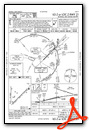
KROW Airport Diagram

VFR Chart of KROW
Sectional Charts at SkyVector.com
IFR Chart of KROW
Enroute Charts at SkyVector.com
Location Information for KROW
Coordinates: N33°17.99' / W104°31.76'Located 03 miles S of Roswell, New Mexico on 5029 acres of land. View all Airports in New Mexico.
Surveyed Elevation is 3671 feet MSL.
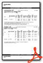
Operations Data
|
|
Airport Communications
| ATIS: | 128.45 306.2 |
|---|---|
| ASOS: | 128.45 Tel. 575-286-1096 |
| ROSWELL TOWER: | 118.5 233.7 |
| ROSWELL GROUND: | 121.9 348.6 |
| ROSWELL APPROACH: | 119.6 ;EAST OF V291 120.35 ;WEST OF V291 229.4 ;WEST OF V291 239.0 ;EAST OF V291 |
| ROSWELL DEPARTURE: | 119.6 ;EAST OF V291 120.35 ;WEST OF V291 229.4 ;WEST OF V291 239.0 ;EAST OF V291 |
| IC: | 119.6 ;EAST OF V291 239.0 ;EAST OF V291 |
| CLEARANCE DELIVERY: | 132.875 282.25 |
| EMERG: | 121.5 243.0 |
| CTAF: | 118.500 |
| UNICOM: | 122.950 |
| AWOS-3 at ATS (27.1 S): | 126.725 575-748-0270 |
| AWOS-3 at SRR (51.0 W): | 126.475 575-336-8455 |
| ASOS at CNM (59.3 S): | 118.375 575-887-6858 |
- APCH/DEP SVC PRVDD BY ALBUQUERQUE ARTCC (ZAB) ON FREQS 132.65/257.6 (ROSWELL RCAG) WHEN ROSWELL APCH CTL (ROW) CLSD.
Nearby Navigation Aids
|
| ||||||||||||||||||||||||||||||||||||||||||||||||


Runway 03/21
| Dimensions: | 13000 x 150 feet / 3962 x 46 meters | |
|---|---|---|
| Surface: | Concrete in Excellent Condition | |
| Weight Limits: | S-100, D-200, ST-400
PCR VALUE: 1140/R/C/W/T
| |
| Edge Lighting: | Medium Intensity NSTD 75 FT FM RWY EDGE. | |
| Runway 03 | Runway 21 | |
| Coordinates: | N33°17.17' / W104°32.21' | N33°18.68' / W104°30.41' |
| Elevation: | 3667.2 | 3623.7 |
| Traffic Pattern: | Right | Left |
| Runway Heading: | 45° True | 225° True |
| Declared Distances: | TORA:13000 TODA:13000 ASDA:13000 LDA:13000 | TORA:13000 TODA:13000 ASDA:13000 LDA:13000 |
| Markings: | Non-Precision Instrument in good condition. | Precision Instrument in good condition. |
| Glide Slope Indicator | V6L (3.00° Glide Path Angle) | |
| Approach Lights: | MALSR 1,400 Foot Medium-intensity Approach Lighting System with runway alignment indicator lights. | |
Runway 17/35
| Dimensions: | 10008 x 100 feet / 3050 x 30 meters | |
|---|---|---|
| Surface: | Asphalt / Grooved in Good Condition | |
| Weight Limits: | S-77, D-104, ST-165
PCR VALUE: 150/R/C/W/T
| |
| Edge Lighting: | Medium Intensity | |
| Runway 17 | Runway 35 | |
| Coordinates: | N33°18.91' / W104°32.35' | N33°17.26' / W104°32.36' |
| Elevation: | 3662.4 | 3671.0 |
| Traffic Pattern: | Right | Left |
| Runway Heading: | 180° True | 0 |
| Declared Distances: | TORA:10008 TODA:10008 ASDA:10008 LDA:10008 | TORA:10008 TODA:10008 ASDA:10008 LDA:10008 |
| Markings: | Precision Instrument in good condition. | Precision Instrument in good condition. |
| Glide Slope Indicator | P4L (3.00° Glide Path Angle) PAPI UNUSBL BYD 8 DEG RIGHT OF CNTRLN. | P4L (3.00° Glide Path Angle) |
Helipad H1
| Dimensions: | 55 x 55 feet / 17 x 17 meters | |
|---|---|---|
| Surface: | Asphalt | |
| Coordinates: | N33°18.45' / W104°31.82' | N0°0.00' / E0°0.00' |
| Elevation: | 3660.0 | |
Helipad H2
| Dimensions: | 55 x 55 feet / 17 x 17 meters | |
|---|---|---|
| Surface: | Asphalt | |
| Coordinates: | N33°18.31' / W104°31.58' | N0°0.00' / E0°0.00' |
| Elevation: | 3653.0 | |
Services Available
| Fuel: | 100LL (blue), Jet-A, Jet A-1+ |
|---|---|
| Transient Storage: | Hangars,Tiedowns |
| Airframe Repair: | MINOR |
| Engine Repair: | MINOR |
| Bottled Oxygen: | NOT AVAILABLE |
| Bulk Oxygen: | LOW |
| Other Services: | AIR FREIGHT SERVICES,AIR AMBULANCE SERVICES,PILOT INSTRUCTION |
Ownership Information
| Ownership: | Publicly owned | |
|---|---|---|
| Owner: | CITY OF ROSWELL | J GRIEGO. |
| 425 N RICHARDSON AVE | ||
| ROSWELL, NM 88201-4730 | ||
| 575-624-6700 | ||
| Manager: | BOBBI THOMPSON | |
| 1 JERRY SMITH CIR | ||
| ROSWELL, NM 88203-8427 | ||
| 239-980-5114 | ||
Other Remarks
- AFT HR EXIT RAMP/FBO AREA USE LGTD PEDESTRIAN GATE - 575-347-2054.
- BIRDS ON & INVOF ARPT.
- LRG ACFT LONG TERM STORAGE AVBL.
- FOR CD IF UNA TO CTC ON FSS FREQ, CTC ALBUQUERQUE ARTCC AT 505-856-4561.
- 0LL AFT HR - 575-347-2054.
- ACTVT MALSR RWY 21; MIRL RWY 17/35 - CTAF. VASI RWY 03; PAPI RWY 17 & 35 - ON CONSLY. WHEN ATCT CLSD MIRL RWY 03/21 ON MED INTST.
Weather Minimums

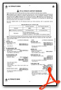
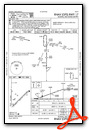
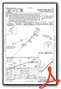
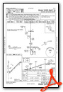
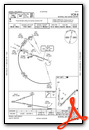
Instrument Approach Procedure (IAP) Charts


Nearby Airports with Instrument Procedures
| ID | Name | Heading / Distance | ||
|---|---|---|---|---|
 |
KATS | Artesia Municipal Airport | 173° | 27.0 |
|
KSRR | Sierra Blanca Regional Airport | 281° | 51.2 |
|
KCNM | Cavern City Air Trml Airport | 166° | 59.2 |
|
E06 | Lea County/Zip Franklin Memorial Airport | 109° | 60.1 |
|
KPRZ | Portales Municipal Airport | 047° | 75.5 |
|
KHOB | Lea County Regional Airport | 118° | 75.7 |
|
KALM | Alamogordo-White Sands Regional Airport | 249° | 78.7 |
|
KHMN | Holloman AFB Airport | 251° | 84.0 |
|
F98 | Yoakum County Airport | 092° | 85.6 |
|
KCVS | Cannon AFB Airport | 042° | 88.6 |
|
KCVN | Clovis Regional Airport | 046° | 99.1 |
|
KGNC | Gaines County Airport | 111° | 101.8 |
Airport Images

By: adh

By: Skywalker


