Login
Register


HOB
Lea County Regional Airport
Official FAA Data Effective 2025-12-25 0901Z
Chart Supplement

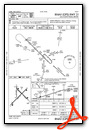
KHOB Airport Diagram

VFR Chart of KHOB
Sectional Charts at SkyVector.com
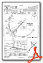
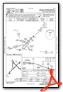
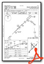
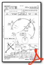
IFR Chart of KHOB
Enroute Charts at SkyVector.com
Location Information for KHOB
Coordinates: N32°41.24' / W103°13.05'Located 04 miles W of Hobbs, New Mexico on 898 acres of land. View all Airports in New Mexico.
Surveyed Elevation is 3660 feet MSL.
Operations Data
|
|
Airport Communications
| ATIS: | 119.75 |
|---|---|
| AWOS-3: | Tel. 575-393-8418 |
| HOBBS TOWER: | 120.65 317.4 |
| HOBBS GROUND: | 121.9 |
| EMERG: | 121.5 243.0 |
| UNICOM: | 122.950 |
| CTAF: | 120.650 |
| AWOS-3PT at E57 (25.4 NE): | 118.275 806-592-3681 |
| AWOS-3 at GNC (28.6 E): | 118.075 432-758-3102 |
| AWOS-3 at E11 (41.0 SE): | 118.2 432-524-2471 |
- APCH/DEP CTL SVC PRVDD BY FORT WORTH ARTCC (ZFW) ON FREQS 133.1/298.95 (HOBBS RCAG).
Nearby Navigation Aids
|
| ||||||||||||||||||||||||||||||||||||||||||||||||||||||||||||


Runway 04/22
| Dimensions: | 8000 x 150 feet / 2438 x 46 meters | |
|---|---|---|
| Surface: | Asphalt / Porous Friction Course in Good Condition | |
| Weight Limits: | S-112, D-168, ST-259
PCR VALUE: 410/F/C/X/T
| |
| Edge Lighting: | High Intensity | |
| Runway 04 | Runway 22 | |
| Coordinates: | N32°40.65' / W103°13.64' | N32°41.58' / W103°12.53' |
| Elevation: | 3653.9 | 3646.4 |
| Traffic Pattern: | Left | Left |
| Runway Heading: | 45° True | 225° True |
| Displaced Threshold: | 602 Feet | |
| Declared Distances: | TORA:8000 TODA:8000 ASDA:8000 LDA:7398 | TORA:8000 TODA:8000 ASDA:8000 LDA:8000 |
| Markings: | Precision Instrument in good condition. | Non-Precision Instrument in good condition. |
| Glide Slope Indicator | P4L (3.00° Glide Path Angle) | |
| Approach Lights: | MALSR 1,400 Foot Medium-intensity Approach Lighting System with runway alignment indicator lights. | |
| REIL: | Yes | |
Runway 13/31
| Dimensions: | 6002 x 150 feet / 1829 x 46 meters | |
|---|---|---|
| Surface: | Asphalt in Good Condition | |
| Weight Limits: | S-120, D-171, ST-279
PCR VALUE: 200/F/C/X/T
| |
| Edge Lighting: | Medium Intensity | |
| Runway 13 | Runway 31 | |
| Coordinates: | N32°41.63' / W103°13.28' | N32°40.93' / W103°12.45' |
| Elevation: | 3660.5 | 3637.6 |
| Traffic Pattern: | Left | Left |
| Runway Heading: | 135° True | 315° True |
| Declared Distances: | TORA:6002 TODA:6002 ASDA:6002 LDA:6002 | TORA:6002 TODA:6002 ASDA:6002 LDA:6002 |
| Markings: | Non-Precision Instrument in good condition. | Non-Precision Instrument in good condition. |
| Glide Slope Indicator | P4L (3.00° Glide Path Angle) | P4R (3.00° Glide Path Angle) |
Runway 17/35
| Dimensions: | 4370 x 100 feet / 1332 x 30 meters | |
|---|---|---|
| Surface: | Asphalt in Good Condition | |
| Weight Limits: | S-32, D-50
PCR VALUE: 80/F/D/X/T
| |
| Runway 17 | Runway 35 | |
| Coordinates: | N32°41.77' / W103°13.25' | N32°41.05' / W103°13.25' |
| Elevation: | 3659.7 | 3650.7 |
| Traffic Pattern: | Left | Left |
| Runway Heading: | 180° True | 0 |
| Displaced Threshold: | 492 Feet | |
| Declared Distances: | TORA:4370 TODA:4370 ASDA:4370 LDA:3878 | TORA:4370 TODA:3418 ASDA:3878 LDA:3878 |
| Markings: | Precision Instrument in good condition. | Non-Precision Instrument in good condition. |
Services Available
| Fuel: | 100LL (blue), Jet-A |
|---|---|
| Transient Storage: | Hangars,Tiedowns |
| Airframe Repair: | NOT AVAILABLE |
| Engine Repair: | MINOR |
| Bottled Oxygen: | NOT AVAILABLE |
| Bulk Oxygen: | NOT AVAILABLE |
| Other Services: | AIR FREIGHT SERVICES,AIR AMBULANCE SERVICES,CARGO HANDLING SERVICES |
Ownership Information
| Ownership: | Publicly owned | |
|---|---|---|
| Owner: | LEA COUNTY | |
| 100 N MAIN AVE, COURTHOUSE BOX 5C | ||
| LOVINGTON, NM 88260-4000 | ||
| 575-396-8521 | ||
| Manager: | COREY NEEDHAM | |
| 100 N MAIN AVE, COURTHOUSE BOX 5C | ||
| LOVINGTON, NM 88260-4000 | ||
| 575-391-2934 | ||
Other Remarks
- FOR CD IF UNA TO CTC ON FSS FREQ, CTC FORT WORTH ARTCC AT 817-858-7584.
- WHEN ATCT CLSD REIL RWY 22; HIRL RWY 04/22; MIRL RWY 13/31 PRESET LOW INTST; TO INCR INTST & ACTVT MALSR RWY 04; PAPI RWY 22, 13, & 31; TWY LGTS - CTAF.
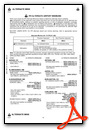
Weather Minimums

Instrument Approach Procedure (IAP) Charts
Nearby Airports with Instrument Procedures
| ID | Name | Heading / Distance | ||
|---|---|---|---|---|
 |
E06 | Lea County/Zip Franklin Memorial Airport | 328° | 18.7 |
|
KGNC | Gaines County Airport | 091° | 28.6 |
|
F98 | Yoakum County Airport | 031° | 37.3 |
|
E11 | Andrews County Airport | 121° | 40.9 |
|
KINK | Winkler County Airport | 179° | 54.3 |
|
KCNM | Cavern City Air Trml Airport | 248° | 57.0 |
|
KBFE | Terry County Airport | 060° | 59.4 |
|
KODO | Odessa-Schlemeyer Field Airport | 137° | 62.3 |
|
KATS | Artesia Municipal Airport | 279° | 64.0 |
|
KLUV | Lamesa Municipal Airport | 086° | 65.8 |
|
KLLN | Levelland Municipal Airport | 039° | 67.1 |
|
E01 | Roy Hurd Memorial Airport | 166° | 68.0 |
Fuel Providers

Airport Images
Do you have a recent image of this airport? Upload it here!


