Login
Register


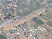
S40
Prosser Airport
Official FAA Data Effective 2026-02-19 0901Z
Chart Supplement

VFR Chart of S40
Sectional Charts at SkyVector.com
IFR Chart of S40
Enroute Charts at SkyVector.com
Location Information for S40
Coordinates: N46°12.80' / W119°47.73'Located 01 miles NW of Prosser, Washington on 120 acres of land. View all Airports in Washington.
Surveyed Elevation is 705 feet MSL.
Operations Data
|
|
Airport Communications
| AWOS-1: | 121.125 Tel. 509-786-8889 |
|---|---|
| UNICOM: | 122.800 |
| CTAF: | 122.800 |
| AWOS-3PT at 1S5 (10.1 NW): | 123.675 509-836-2384 |
| AWOS-3PT at RLD (21.1 E): | 132.675 509-375-4247 |
| ATIS at PSC (28.2 E): | 125.65 |
Nearby Navigation Aids
|
| ||||||||||||||||||||||||||||||||||||||||||||||||||||||


Runway 08/26
| Dimensions: | 3452 x 61 feet / 1052 x 19 meters | |
|---|---|---|
| Surface: | Asphalt in Excellent Condition | |
| Weight Limits: | S-16 | |
| Edge Lighting: | Medium Intensity | |
| Runway 08 | Runway 26 | |
| Coordinates: | N46°12.80' / W119°48.14' | N46°12.80' / W119°47.32' |
| Elevation: | 705.5 | 683.4 |
| Traffic Pattern: | Left | Right |
| Runway Heading: | 90° True | 270° True |
| Markings: | Basic in fair condition. | Basic in fair condition. |
| REIL: | Yes | Yes |
| Obstacles: | 71 ft Trees 2075 ft from runway | |
Services Available
| Fuel: | 100LL (blue) |
|---|---|
| Transient Storage: | Tiedowns PILOTS BRING OWN ROPES. |
| Airframe Repair: | NONE |
| Engine Repair: | NONE |
| Bottled Oxygen: | NONE |
| Bulk Oxygen: | NONE |
| Other Services: | PILOT INSTRUCTION |
Ownership Information
| Ownership: | Publicly owned | |
|---|---|---|
| Owner: | PORT OF BENTON | |
| PORT OF BENTON BLVD | ||
| RICHLAND, WA 99354 | ||
| 509-375-3060 | ||
| Manager: | QUENTIN WRIGHT | |
| 3250 PORT OF BENTON BLVD | ||
| RICHLAND, WA 99354 | ||
| 509-975-6352 | CELL NUMBER 509-578-6159 | |
Other Remarks
- TWYS MKD FOR NGT OPNS WITH RETRO-REFLECTIVE DEVICES.
- FOR CD CTC SPOKANE APCH AT 509-742-2525, WHEN APCH CLSD CTC SEATTLE ARTCC AT 253-351-3694.
- AIRFIELD CONDS UNMON.
- ACTVT REIL RWYS 08 & 26; MIRL RWY 08/26 - CTAF.
- UNICOM 122.8 0900-1700 ONLY.
Nearby Airports with Instrument Procedures
| ID | Name | Heading / Distance | ||
|---|---|---|---|---|
 |
KRLD | Richland Airport | 074° | 21.2 |
|
KPSC | Tri-Cities Airport | 083° | 28.3 |
|
KHRI | Hermiston Municipal Airport | 135° | 32.2 |
|
KYKM | Yakima Air Trml/Mcallister Field Airport | 304° | 37.7 |
|
9S9 | Lexington Airport | 174° | 45.8 |
|
KPDT | Eastern Oregon Regional At Pendleton Airport | 127° | 50.6 |
|
KELN | Bowers Field Airport | 328° | 57.9 |
|
KMWH | Grant County International Airport | 018° | 62.9 |
|
KALW | Walla Walla Regional Airport | 096° | 63.5 |
|
KEPH | Ephrata Municipal Airport | 009° | 66.7 |
|
KDLS | Columbia Gorge Regional/The Dalles Municipal Airport | 238° | 67.7 |
|
KEAT | Pangborn Memorial Airport | 346° | 73.1 |
Airport Images
By: jbellwoo

By: anonymous


